
Lining Up Mystara Revisited III
I outlined three problems at the end of the first article:
- Latitude
- Size
- Projection
Our challenge is to try to reconcile the various models into a single 2018 model that solves or at least minimises the effects of these problems while preserving the existing maps (and the text they’re based on) as much as possible.
As with the last Lining Up project, I’m going to do this by exploring the possibilities and soliciting feedback from the Mystara community.
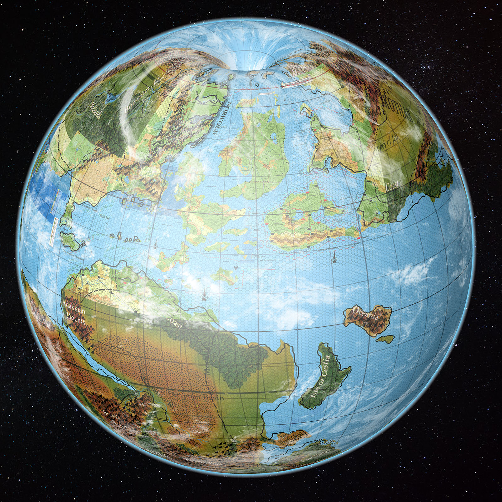
Solution 1: Use Jurassic Mystara as is.
The Jurassic-based world shows the true shapes of the continents.
Fit our assembled coastlines to Jurassic Mystara, shifting land masses as necessary within the confines of the hex grid. As detailed in the last article, some displacement is necessary to fit Brun in its more southerly position while still fitting in the Isle of Dawn, Ochalea and the Pearl Islands, but hopefully it’s doable.
Pros:
- Projection: Uses the map in its true projection, with continents in their originally intended positions, and no pinching at the poles.
- Projection: All existing hex maps can be georegistered with no alterations.
- Size: The world can still be scaled as necessary.
- Latitude: Only the extreme polar regions fall into the polar openings.
- Further Development: Jurassic Earth maps can be easily used for continental shelf and other details.
Cons:
- Latitude: these are very different from official figures, with Thyatis around 25-27º, and Farend likely around 51º.
- Size: Scaling of the world may result in an Outer World that’s far too big.
This is my favoured solution, for the simple reason that it preserves the hex maps as best we can. The nature of the Mollweide projection as an equal area projection means all hexes share the same area, regardless of where they appear on the globe. Distance and shape are not constant, so the nominal hex scales (e.g. “8 miles per hex”) will not be entirely accurate. But this is going to be the case whatever solution we choose.
Further, the latitude problem can be solved by re-evaluating Mystara’s climate as being overall slightly cooler than the real world. To be honest, we probably should have been doing this anyway.
This leaves the problem of size. I’m still working on this, but I believe I can get it to work. Key to this is that lower Outer World latitudes allow a little leeway for where the polar lip begins. If I can lower the starting latitude by even a degree or two, it makes a big difference to the viability of the model.
Solution 2: Create a hybrid.
Use the shapes from Jurassic Mystara to fix the 2016 model (cut and paste method).
Reproject Jurassic Mystara’s Mollweide into Equirectangular, then cut and paste to fix the shapes. Equatorial regions of the world are similar in both projections, making this a possible solution.
Pros:
- Overall: The model is already established as a working model of Mystara.
- Projection: This compromise would fix the polar regions.
- Latitude: These already match official figures. Known World latitudes would stay the same, while northern latitudes may be compressed slightly.
Cons:
- Projection: It’s messy. Extremely messy. We’re talking about taking a hacksaw to the world and massively rearranging it.
- Projection: The extremes of the world must be placed in the polar openings, so the projection would not be quite right.
- Projection: In other words, the shapes are not quite correct, but rather a hybrid, not quite matching any existing maps.
- Projection: Worst of all, perhaps, all existing hex maps are left in a strange limbo, not quite fitting the new configuration of the world.
This was the first solution I thought of, and my preferred solution until I realised the last point I listed under cons: that doing this would likely break the connection between the original model and the hex maps, leaving them in a strange limbo.
It’s certainly doable, however. Is it worth investigating further? I’ll leave that up to your feedback.
Solution 3: Move the continents
Use the shapes from Jurassic Mystara to fix the 2016 model (tectonic plate method).
A variant of the previous solution, using tectonic plate software such as GPlates to move the landmasses on the globe itself.
Pros:
- Projection: The proper shapes of the landmasses are preserved.
- Projection: Polar regions are better than on the 2016 model.
- Latitude: these largely match official figures, especially in the Known World.
Cons:
- Projection: It’s hard. Using GPlates to move Brun northwards is possible, but the 2016 model requires it to be moved into the polar opening, which is not possible with any GIS software, as it has to be moved past 90º.
- Projection: The poles are fixed to an extent, but the polar openings need to be eyeballed and done manually. Large sections fall in the polar openings, so this too is hard.
- Projection: The resulting shapes are a hybrid, not matching any existing maps.
- Projection: All existing hex maps would exist in a strange pre-moved limbo, not quite matching the new configuration.
This was the second solution I came up with, and it tries to deal with the messy cutting and pasting of Solution 2 by moving whole continents using tectonic plate modelling.
It’s certainly a fun idea, and I enjoyed looking into the software immensely. But while it would indeed result in almost the exact same shapes for continents as Jurassic Mystara, it has the same problem with making the status of the existing hex maps messy at best.
So you’ve decided already?
You may be wondering why I’m writing this article if I’ve already decided what to do. In fact, my previous article mainly got responses along the lines of “We’re happy with whatever you decide”, and even “In Thorf we trust”! Thank you all for the vote of confidence.
There are three reasons for this series of articles: to ask the community for feedback on my ideas; to document my process for future reference; and last but definitely not least to help me to find the way forward. It’s through writing these articles that my thoughts coalesce and solutions — as well as new problems — present themselves. I’m not so much writing down fully fledged ideas as creating a plan, and each article gets revised and rewritten multiple times before I even reach the end.
So thank you very much for indulging me!
Regardless of the above, please do let me know your preferences for these solutions, as well as any more pros and cons that I didn’t think of.
In the next part, I will report back on my progress with the new model.


21 February 2018 @ 12:23 am
I Would also choose the first option. The second destroys Mystara as we know it, and the third is outright impossible if you take into account that Mystara as being a Living planet has no tectonic, but cellular movement at best. see here my post on the canon compilation (and some add-on by myself as seen from a biological option) http://breathofmystara.blogspot.nl/2013/04/the-megalith-part-2-lesson-by-mergrath.html
the problem of the size is minor I think, as Mystara is only slightly smaller than Jurrasic earth (as per canon). this could well allow for size readjustment. Including those sections faling into the curvature.
21 February 2018 @ 12:53 am
Well, I’m not suggesting actual tectonics; just using the software to move the landmass on the globe, which would allow us to keep the “true” shape of Brun while moving it northwards.
But yes, this would make it look entirely different in whatever projection we then put it in. It’s a fun and creative solution, but ultimately it breaks the hex maps.
(Moving the landmass on a projected map would result in different shapes on the globe.)
By the way, I’m using a hex map-based measurement to extrapolate the size for the world, and this means that it’s actually slightly bigger than Earth.
21 February 2018 @ 12:42 am
I think the Jurassic map can be a great reference to fill in details you don’t already have but shouldn’t the TSR DM-style map and text for DAM have more authority than the Jurassic map? The Jurassic map is the inspiration for the game maps, it’s not the game map. I do love how it shows how to un-pinch the poles and I’m for that.
21 February 2018 @ 12:49 am
Yes, I’m in complete agreement with you there. I argued that very case a couple of weeks ago when I found Lance Duncan’s Mystara Web Map project. Especially, I don’t think it follows that we have to accept Mystara as being ancient Earth in regards to size, which is why I’m still working towards a hex map-based scale.
There is some leeway in fitting the world map to the Jurassic map — it’s not a clear cut perfect fit.
The key, though, is that these shapes look best on the globe when interpreted as the Jurassic map had them. They’re intrinsically linked with the projection that map used, so it makes sense for us to take advantage of this as a boon rather than a problem. I guess this is why I’m most excited about Solution 1: it means all of the hex maps can be georegistered as-is. The truth is that I never dreamed this might be possible.
Lining Up Mystara Revisited IV – Thorfinn Tait Cartography
1 March 2018 @ 9:22 pm
[…] It’s time to solve the problems I brought up in my second article, and then move forward with Solution 1 from last time. […]