
Lining Up Mystara Revisited II
In the next article, I’m going to propose some solutions for your consideration, broken down into pros and cons. But first, there’s the issue of georegistration.
Georegistering Jurassic Mystara
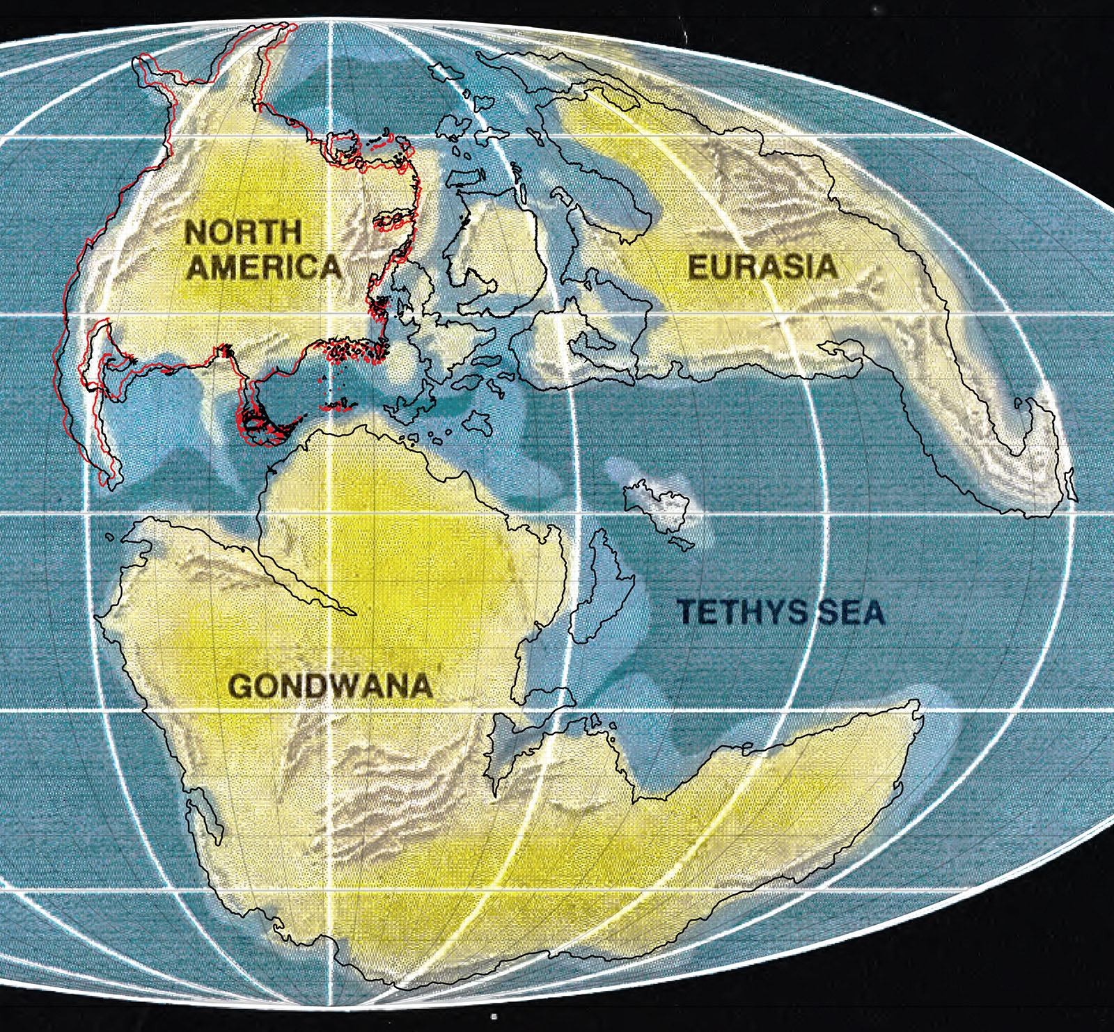
Regardless of which solution we decide upon, Jurassic Mystara will need to be georegistered. This means matching up the coastlines of the Master Set world map — or indeed my 2016 model — to the Jurassic Earth map as closely as possible. With the coastlines in place, we can lock in Jurassic Mystara’s georegistration, and then apply that to all of the other maps.
This is not a precise science: the maps don’t fit perfectly, so exact locations are slightly arbitrary. Nevertheless, the closer the placement is to the Jurassic Earth map, the truer the shapes will be on the globe.
There are a number of decisions to make even with this. Let’s take a look at these now.
The Brun Rotation Conundrum
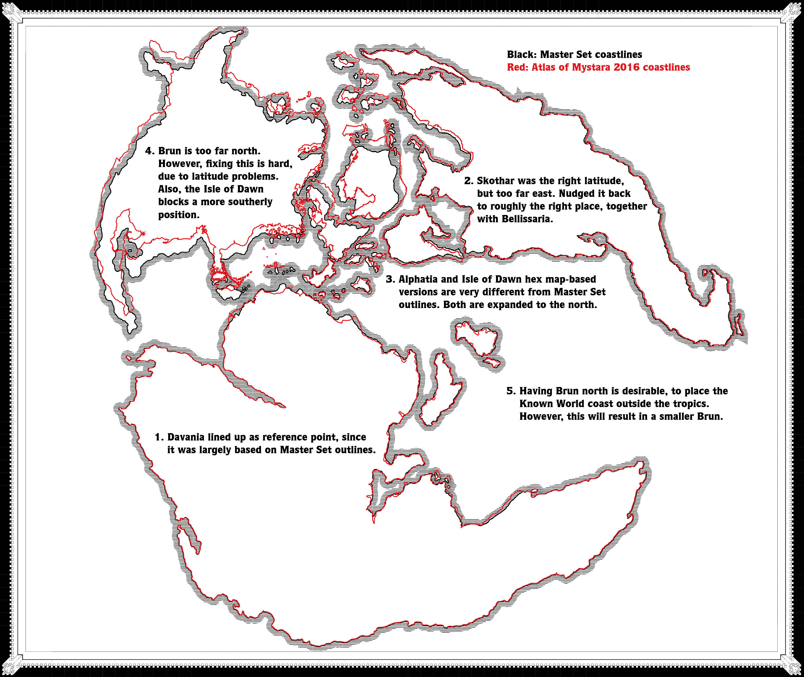
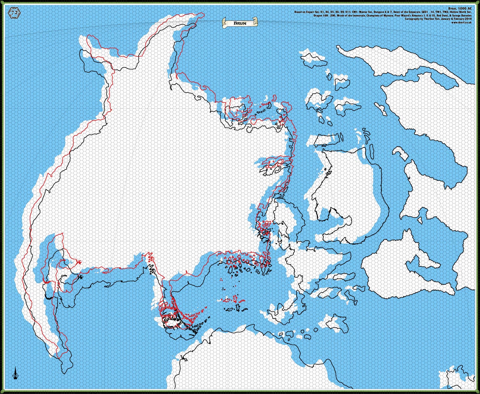
CM1’s continental map of Brun is slightly rotated when compared with the Master Set’s world map, by approximately 2.2º. (You can see this in the image above, where the red outlines are based on CM1 — look at the south coast of Brun and compare the red and black lines.)
The question is, which version is correct?
Notably, all hex maps were based on CM1’s model (to a reasonable degree of accuracy). At the least, they were closer to CM1 than the Master Set map. In my 2016 model I took this to mean that CM1’s version of Brun was more accurate, and adapted the two extremities not on CM1’s map (the tips of Hyperborea and the Arm of the Immortals) by rotating Master Set Brun to fit.
I also used the larger scale hex maps to revise the continental outlines of Brun.
With all of this in mind, I’m inclined to keep this updated version of Brun.
The real clincher for me is that the 2.2º rotation doesn’t seem to give either version of Brun an edge when compared with the Jurassic Earth map; in fact, Brun is a pretty loose fit regardless of which map is chosen.
There’s another benefit to choosing to go with the hex maps and CM1’s Brun over the Master Set outlines: it preserves the east-west axis. Going with the Master Set map means applying the 2.2º rotation to all of the hex maps, resulting in the east-west axis being a slightly diagonal line across the page. (You can see this in Lance Duncan’s Mystara Web Map.)
I don’t really see the benefit of doing this. It’s overly complicated for very little gain — especially when we’re revising the Master Set outlines anyway.
Conclusion: My preference is to go with CM1’s 2.2º rotated version of Brun, so that the hex maps all line up on a straight line from east to west. However, this in turn may affect other issues, for which keep reading.
Relative Continental Positions
The next issue is the relative positions of all the landmasses. In my 2016 model, I went almost exclusively with the large scale hex maps in working out these positions.
However, it’s surely equally valid to go with the original Master Set world map’s positions — especially when the evidence is very slim, as in for example Davania’s position, which I determined based on a tiny fragment of the massive continent in the corner of a 24 mile per hex map from Champions of Mystara.
Now that we know the projection of the world map, this approach seems less useful. Consider that we want to place the continents, especially the largest three landmasses, as close to their positions on the Jurassic Earth map as possible, and it becomes clear that the Master Set world map’s locations are probably the best option.
Conclusion: I propose we keep the placements of the landmasses in relation to the hex grid itself, while shuffling them around within the hex grid to be as close to their Master Set (and indeed Jurassic Earth) locations as possible.
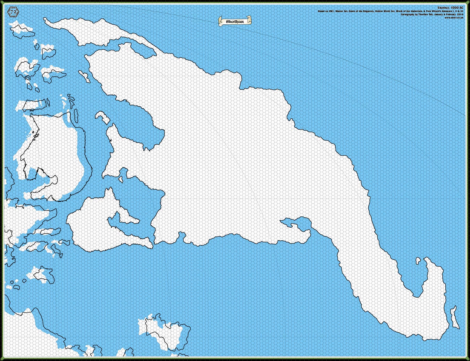
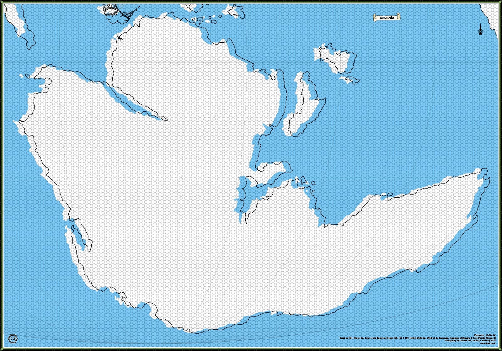
The following three images show my 2016 model’s 72 mile per hex maps (the blue coastal outlines), with black outlines showing the relative positions needed for a provisional best fit with Jurassic Earth. The Brun map further shows the CM1-based rotation’s outlines in red.
Brun’s Position
The last issue (for today at least!) relates to Brun’s position in the world. Due to the enlarged size of the Isle of Dawn compared to the world map, there’s not really room to move Brun south as far as it is shown on the Jurassic Earth map. Moreover, there’s not enough space to move it north either, without clipping northern Hyperborea: lining it up based on the tips of Hyperborea and the Arm of the Immortals, there is essentially no space to play with here in any direction.
And yet this position is highly problematic, as it actually overlaps with the Isle of Dawn.
What to do?
I’d like to keep the relative positions of Brun and the Isle of Dawn if possible, since this is the only one shown on an 8 mile hex map. But this will likely result in shifting around the other islands in the area: Ochalea and the Alatians.
But even moving all of these, there still doesn’t seem to be enough space.
Coming into play here is the 2.2º rotation. In fact, this rotation exacerbates the problem with lack of space; the Master Set world map’s Brun has marginally more space to play with due to the rotation. But it’s still not enough.
Undoubtedly the cause of this problem is the hex maps’ treatment of eastern Brun and the Isle of Dawn.
The only solution I can see, other than changing the proportions of the Isle of Dawn, is to move the whole continent north slightly in order to fit everything in as much as possible. This results in pushing northern Hyperborea past 90º, which means it will vanish when reprojecting from Mollweide to Equirectangular — as must be done in order to place the maps on a 3D model. This is undesirable, but if it can be minimised, it is possible to paint the missing land back in later. (It will fall in the polar opening.)
The other possibility is to distribute the displacement between the continents, by shunting Davania down slightly, too.
To put things in perspective, my calculations show that Brun could do with being about 4 hexes north, measuring with 72 mile hexes. This can be shared with Davania so that they are both two 72 mile hexes further from the equator than the Master Set shows them.
Not too bad. It’s not perfect, unfortunately.
Summing Up
These are some thorny issues. Precisely how to work past them may depend on which solution we adopt. But this is enough for today. Next time, I’ll present my solutions to the wider issues for your consideration.
In the meantime, please let me know what you think about these initial problems.


20 February 2018 @ 12:28 am
I’d prefer the “moving south Davania” a little than make Hyborea “disappear” ^_^
After all Brun is the most “solid” and canon of the 3 major continents.
20 February 2018 @ 7:04 am
Hello Thorf
Interesting post!
I definitely agree to go with CM1’s 2.2 degree rotated version of Brun to ensure the hex maps all line up in a straight line from east to west. Having to make a small rotational adjustment on all of the hex maps should be avoided to preserve the sanity of Mystaran cartographers!
I do agree that moving the ‘known world’ area slightly north is desirable, as my understanding is that the climate described in most of the Gazetteers is cooler than what those lands’ geographic location would suggest. However, an issue I see with shifting Brun north by four 72 mile hexes would be around the city of Alpha. Pushing Alpha north by that much would move it into the sub arctic region on Bruce’s climate map, which would seem to go against the intended placement of it in canon sources. To counter this, are you planning to move the arctic circle four 72 mile hexes to the north as well, so it still lies along the coast of Northern Norwold (where it meets the Norzee)? If not, then I think splitting the placement shift with Davania would be the way to go to avoid future climate issues in the Norwold region.
One quick final question, is Hyperborea a reference to part of Jurassic Mystara, or did you mean Hyborea in standard Mystara?
20 February 2018 @ 11:13 pm
Thanks for commenting, Carillion! It’s always great to hear your feedback on these things.
It’s not so much that we’d have to change the hex maps, but rather that the assumption of east-west being a straight line across the page would need to be reassessed. Actually the north arrows already are completely wrong, but best not to destroy both of these if we can preserve one, right?
If we go with the Jurassic Mystara model, the northern latitudes actually have the opposite problem of being too far south. Even with a shift north, they’re still going to be further south than we thought. I’m going to propose a solution for this in the next post.
As for Hyperborea… Wow, I’ve been saying this for years, I think. And a Google search suggests I’m not the only one to be making this mistake. I must have conflated this with Borea and Hyborea. For some reason I thought that each was further north, but now I see that Hyborea is the northern part. Thanks for clearing this up for me.
On a similar note, I only noticed that Norwold was not Norworld many years after getting into Mystara, so this is not even the first time to make a mistake like this.
Lining Up Mystara Revisited IV – Thorfinn Tait Cartography
23 February 2018 @ 9:00 pm
[…] time to solve the problems I brought up in my second article, and then move forward with Solution 1 from last […]