
Lining Up Mystara XIX
We are rapidly approaching the conclusion of this project. This may even turn out to be the last post, if community feedback is mostly positive. So let’s get into it.
The Atlas of Mystara World Model
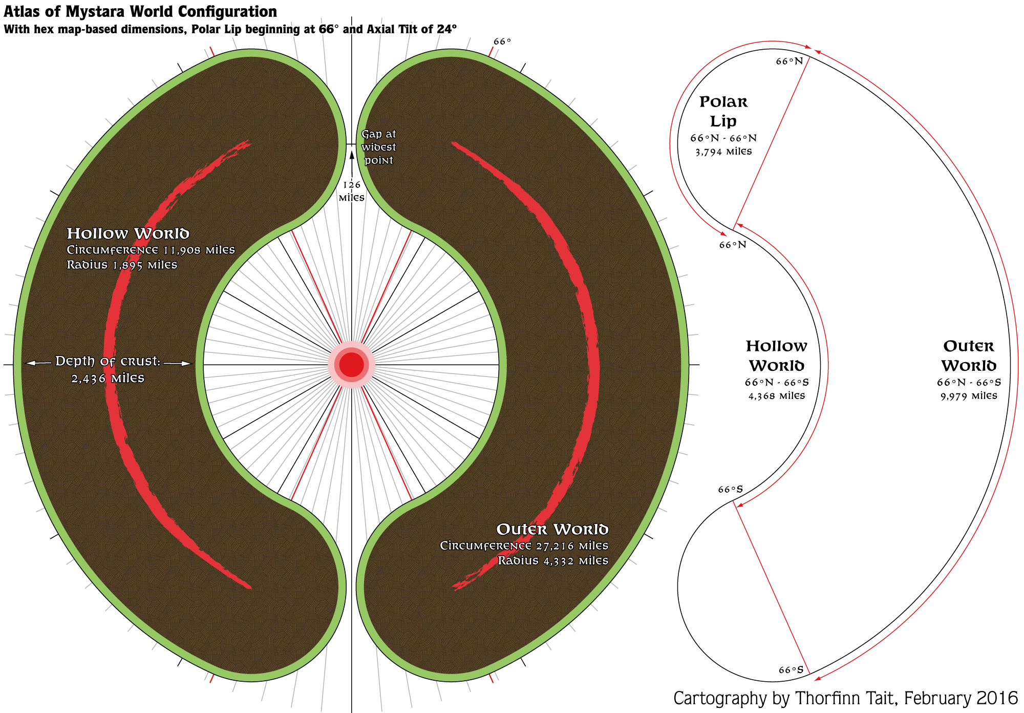
Diagram 1 shows the world model, as determined by the world dimensions we came to previously. All of the diagrams and images in this post are derived from Placement 5, which seemed to be the most popular of the placements I proposed. (There was also support for placement 4, with its tunnel-shaped polar openings, but if we can preserve the polar openings in their original shape, that would be preferable.)
I have split the world into four parts, as illustrated on the right of this diagram: the Hollow World, the Outer World and the two Polar Lips. The north-south measurements of each of these are also given; these are essential for fitting the world maps to the 3D model correctly.
The next three diagrams show the model itself, which is very simply a 3D extrusion of the shape in diagram 1.
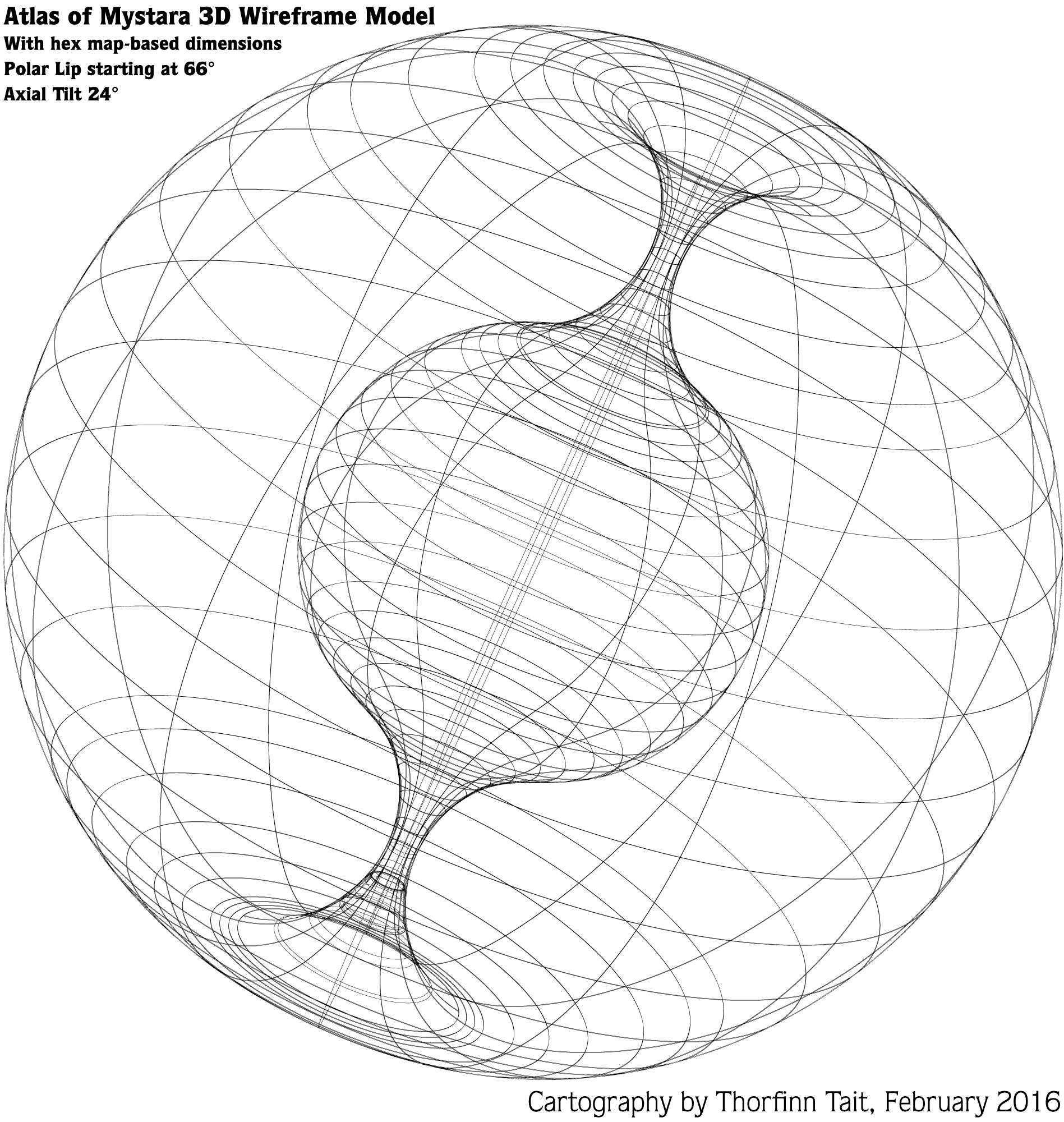
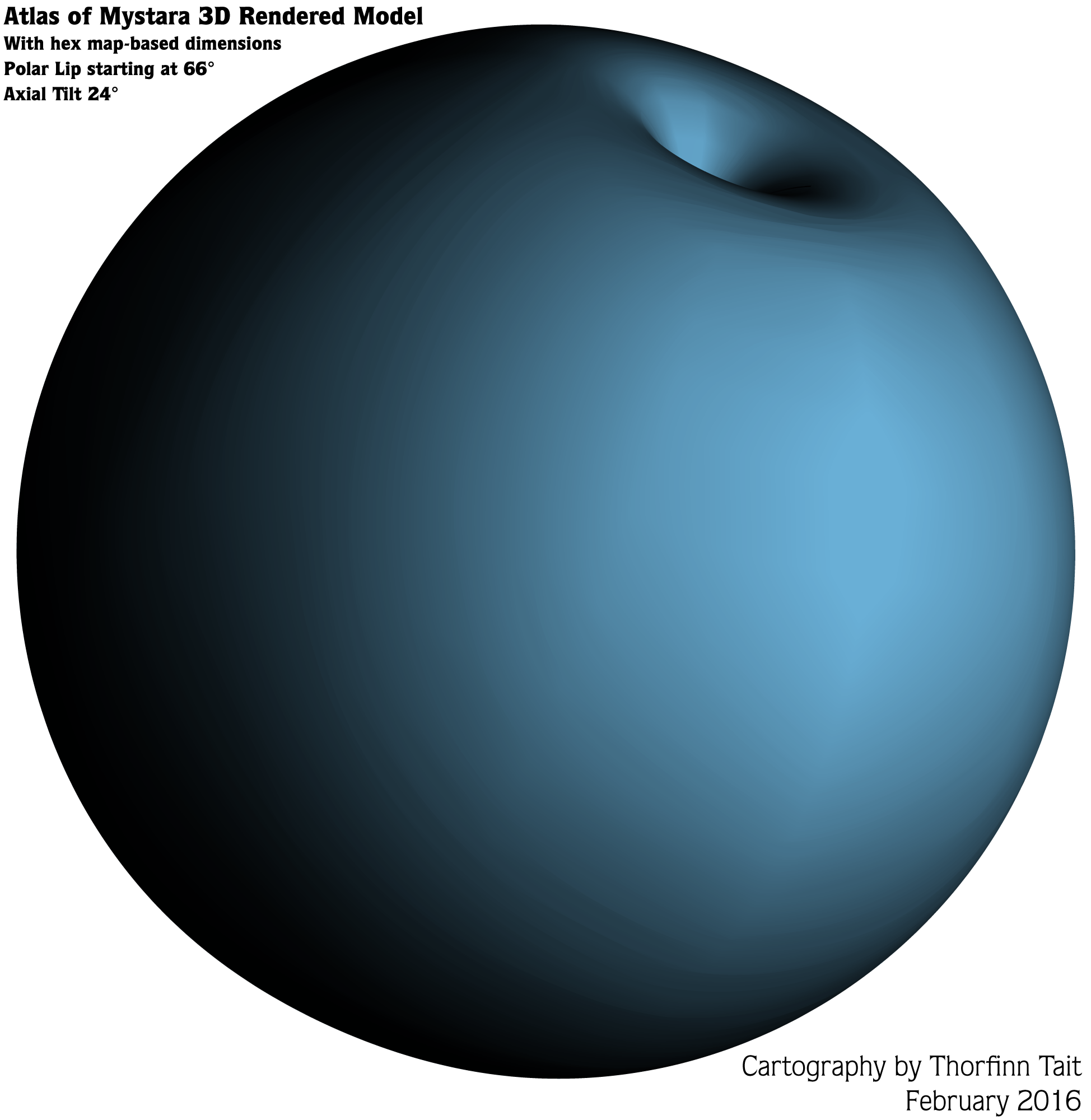
I made the rendered diagrams blue to differentiate from the 2012 versions of these same diagrams.
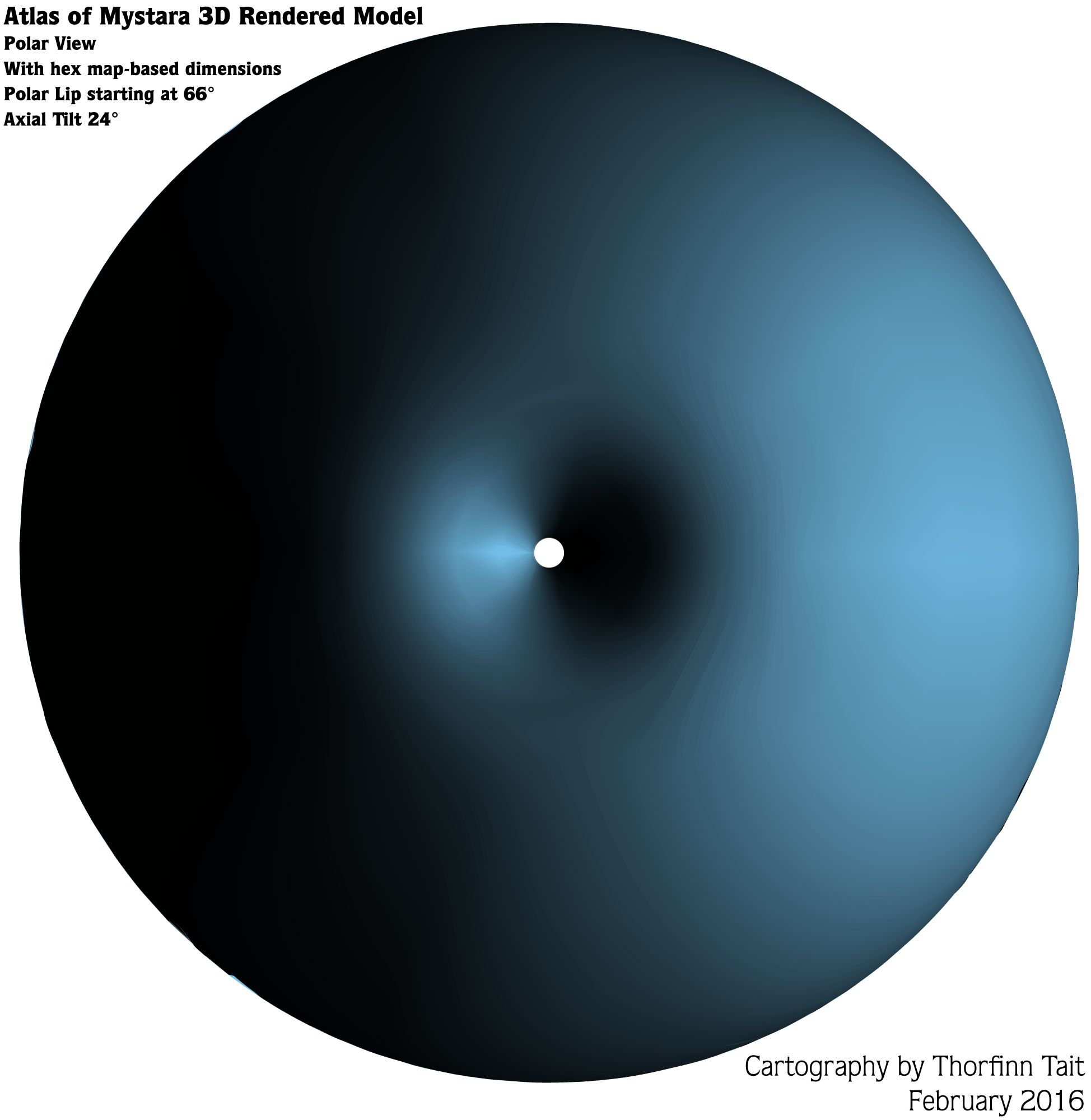
Finally, here’s the sunlight diagram:
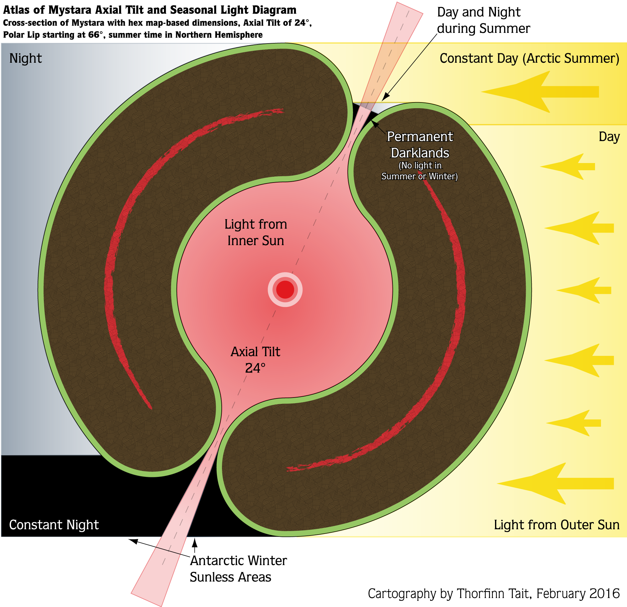
The areas of black marked in the northern polar opening show the extent of the Darklands — where neither sun shines. An area the same size exists in the southern polar opening. There’s also an area which experiences both day and night in summer, marked in grey, but most of the land at the poles gets constant day in midsummer and constant day in midwinter.
With that out of the way, it’s time to explore the model.
Atlas of Mystara 3D Model
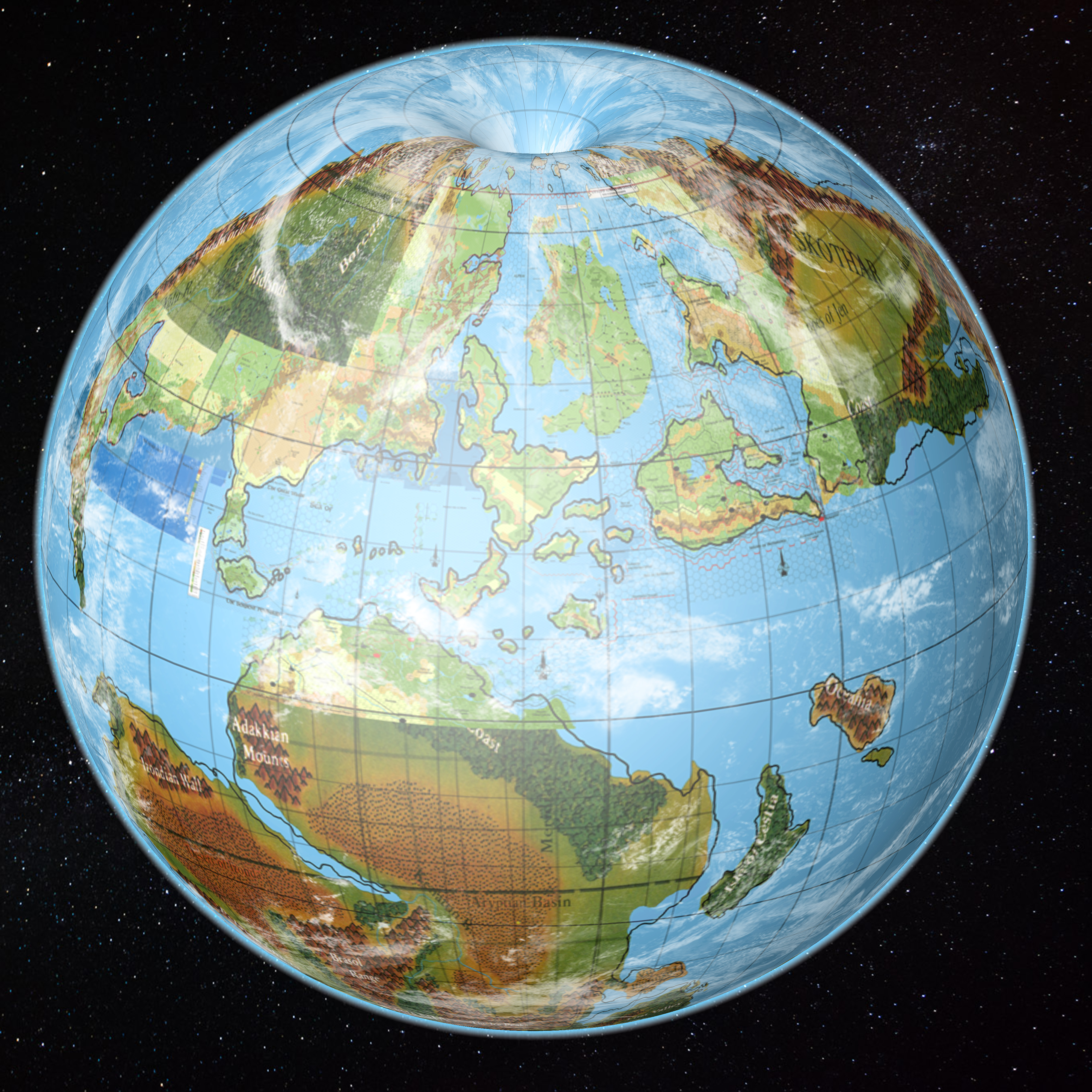
This is it: hopefully the final model and placement. I put some clouds on this one for fun, but the rest of the mock-ups are cloud free for better clarity.
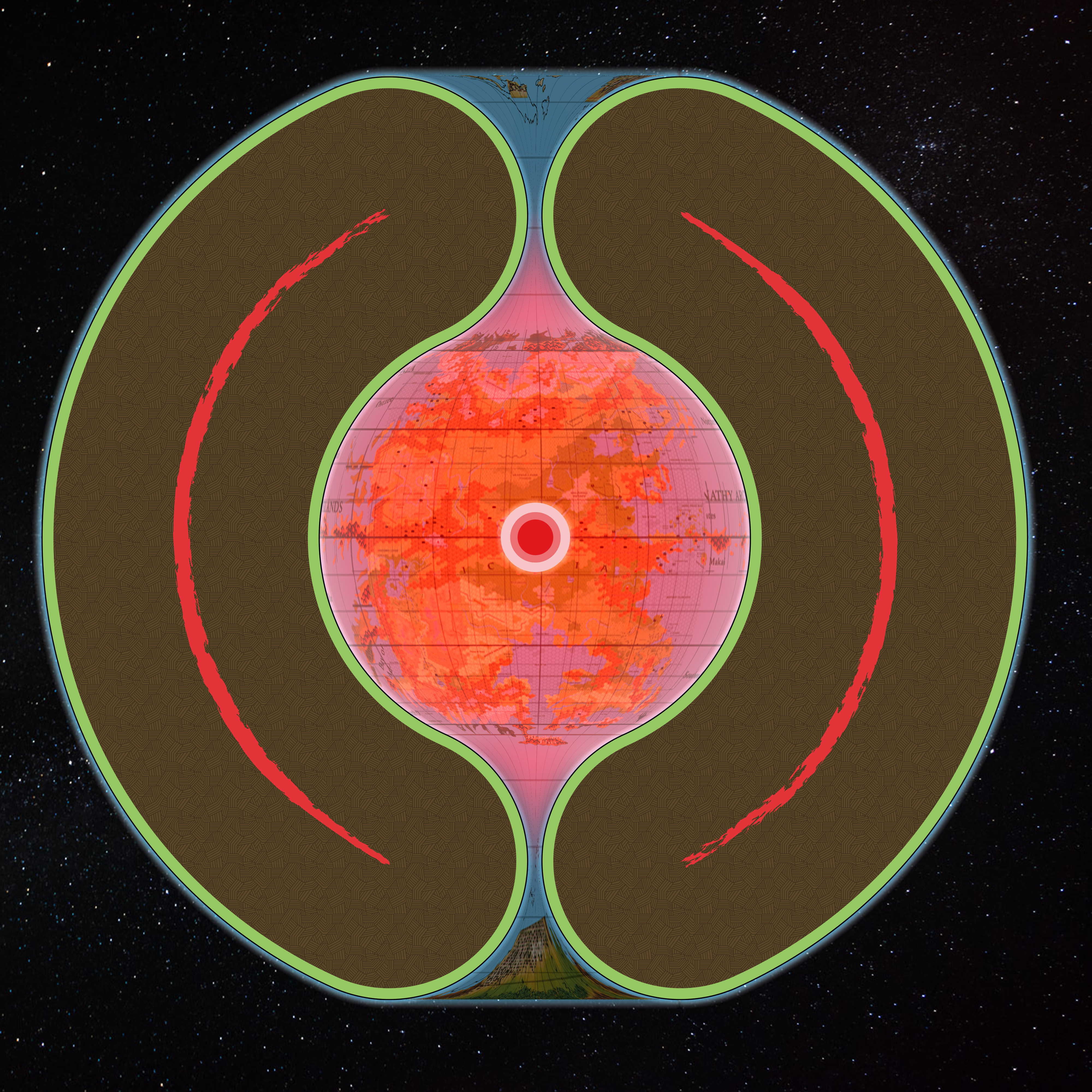
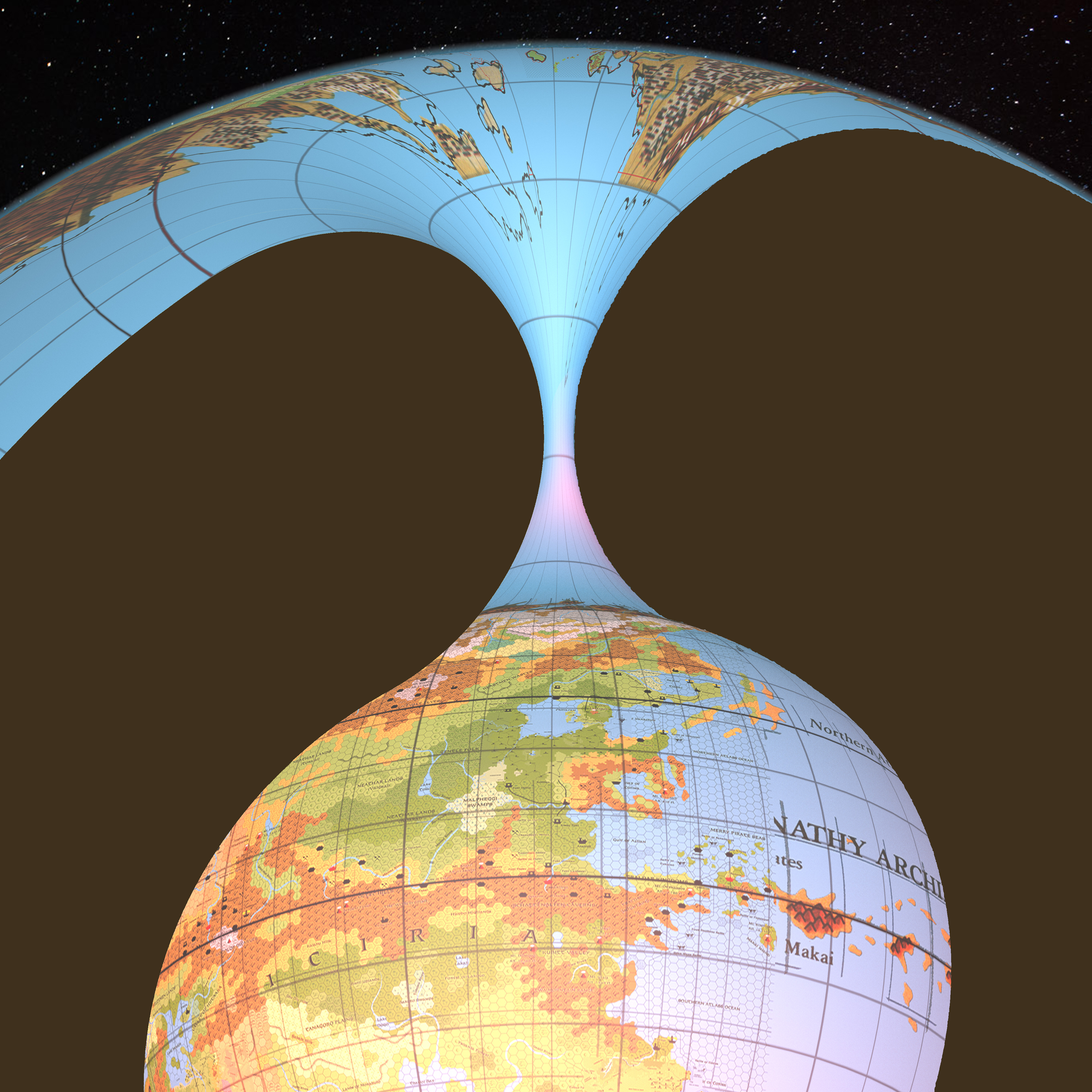
From straight on, Mystara looks like a ball with its top and bottom cut off:
The latitudes seem to be working rather well, don’t you think?
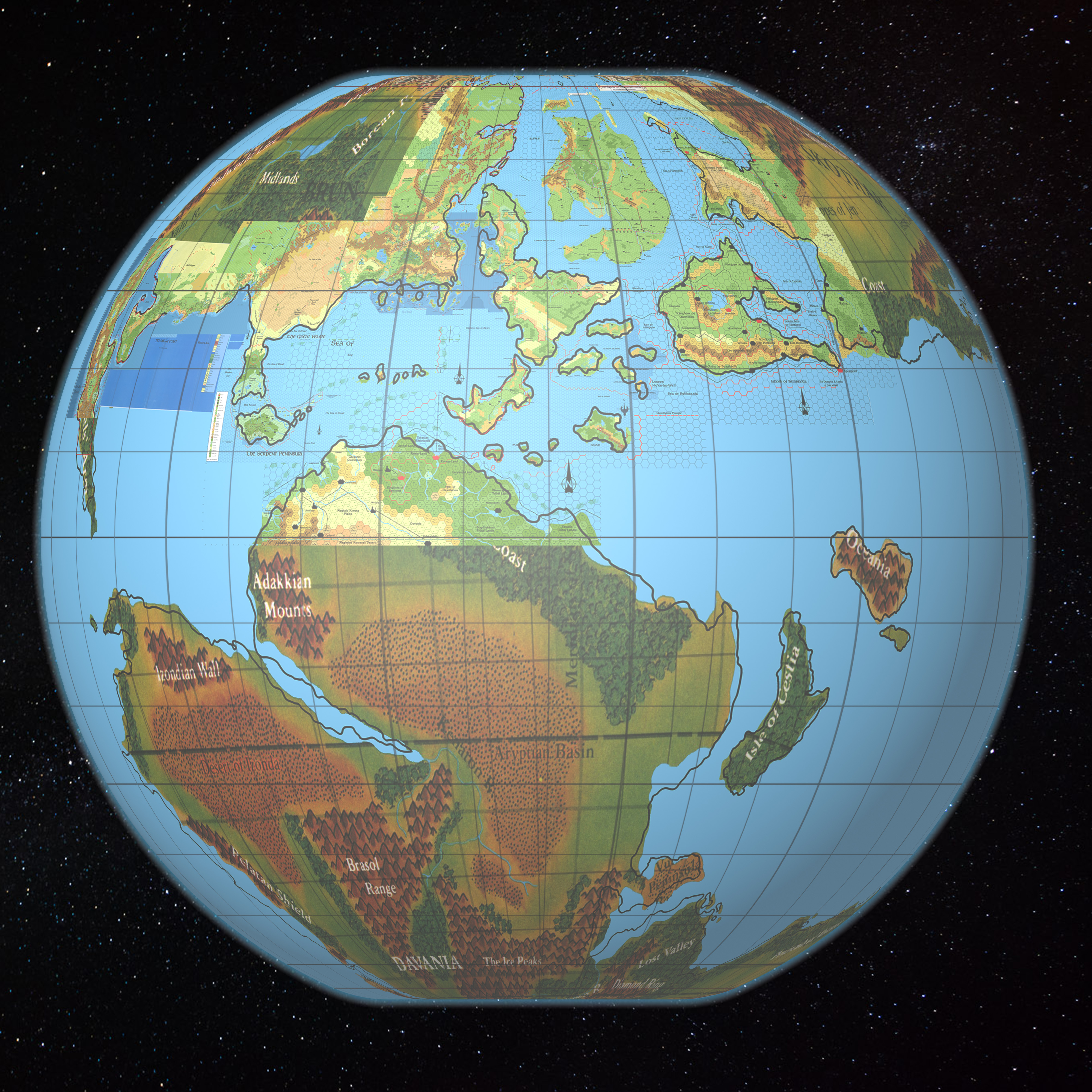
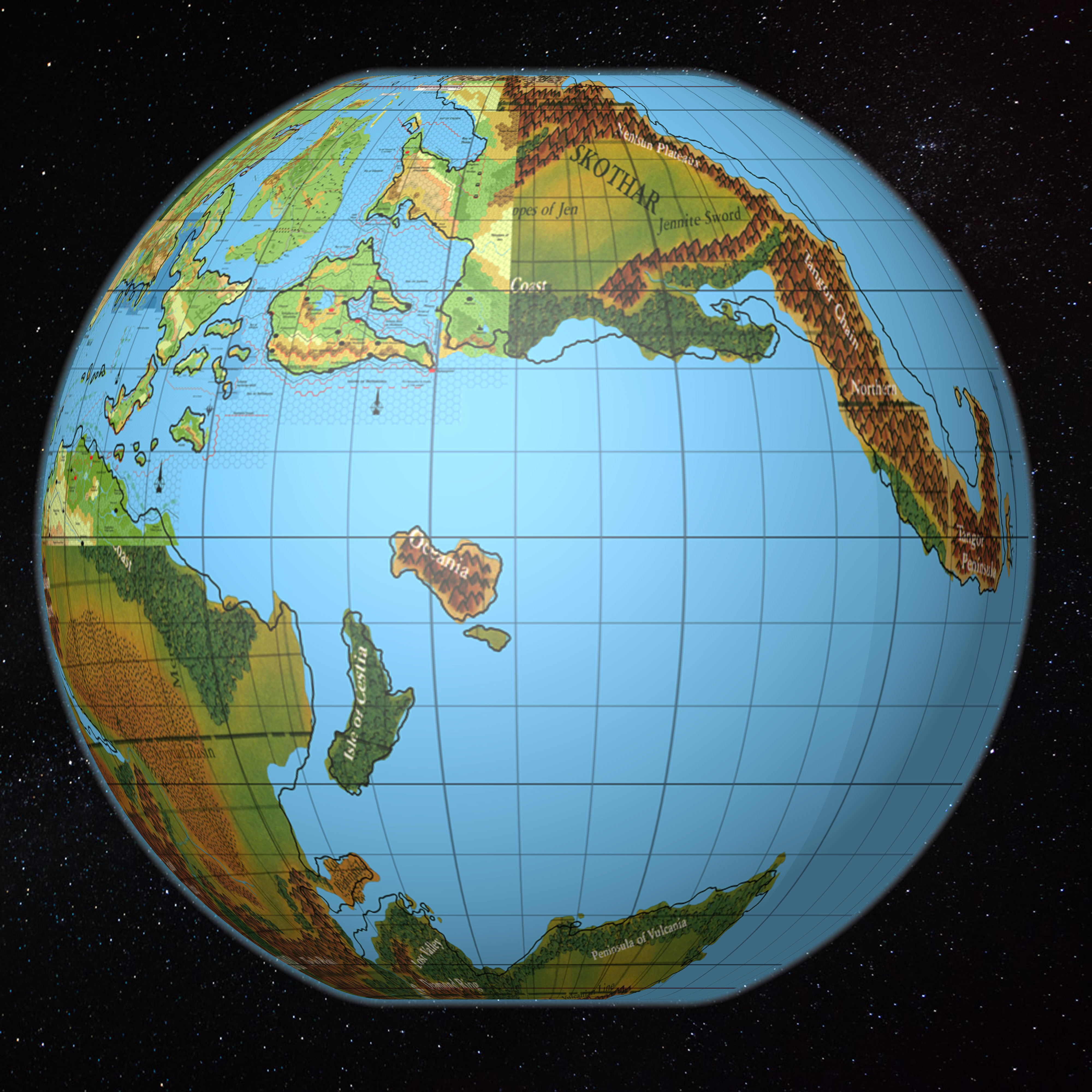
Here’s a better view of the Arm of the Immortals and the Savage Coast area:
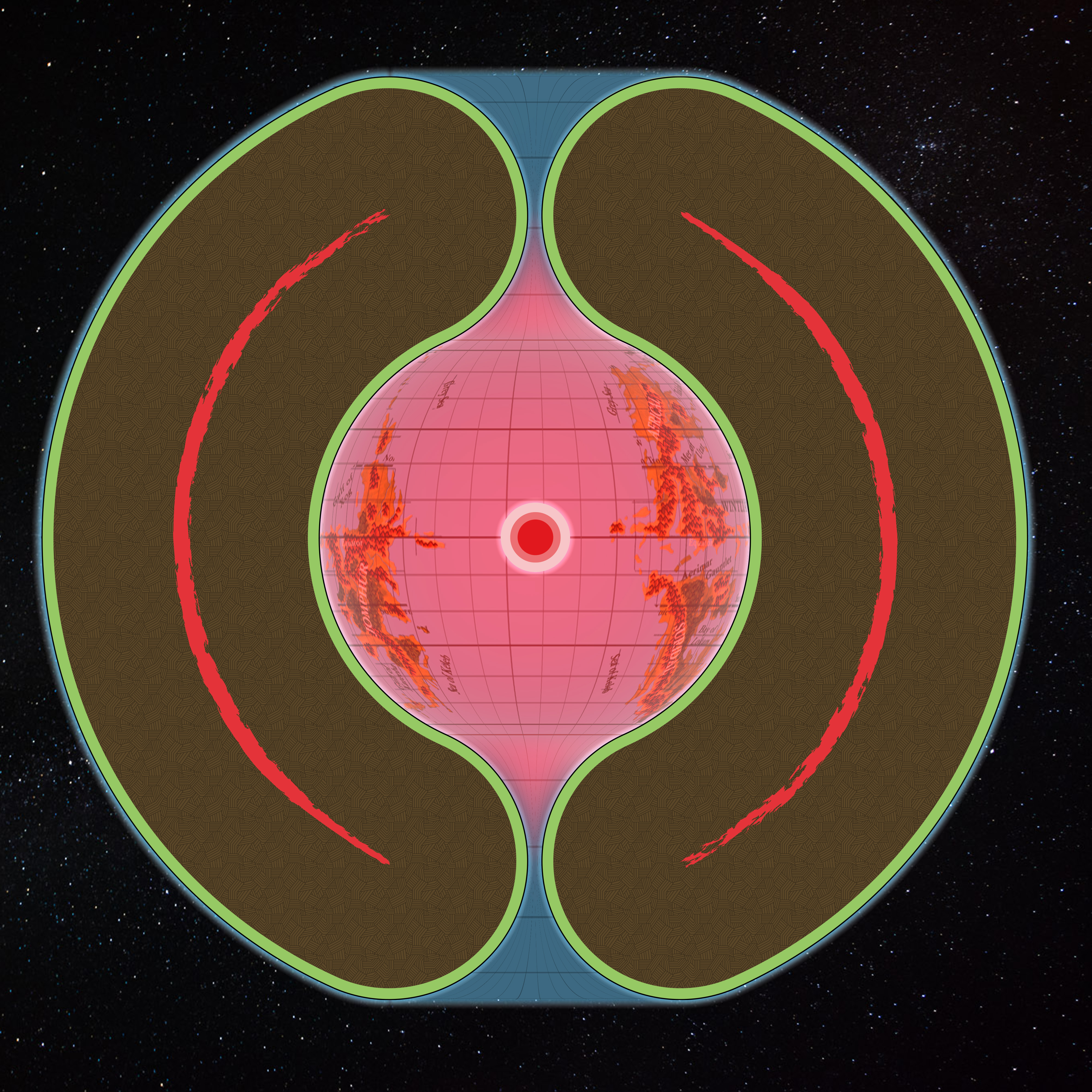
Skothar:
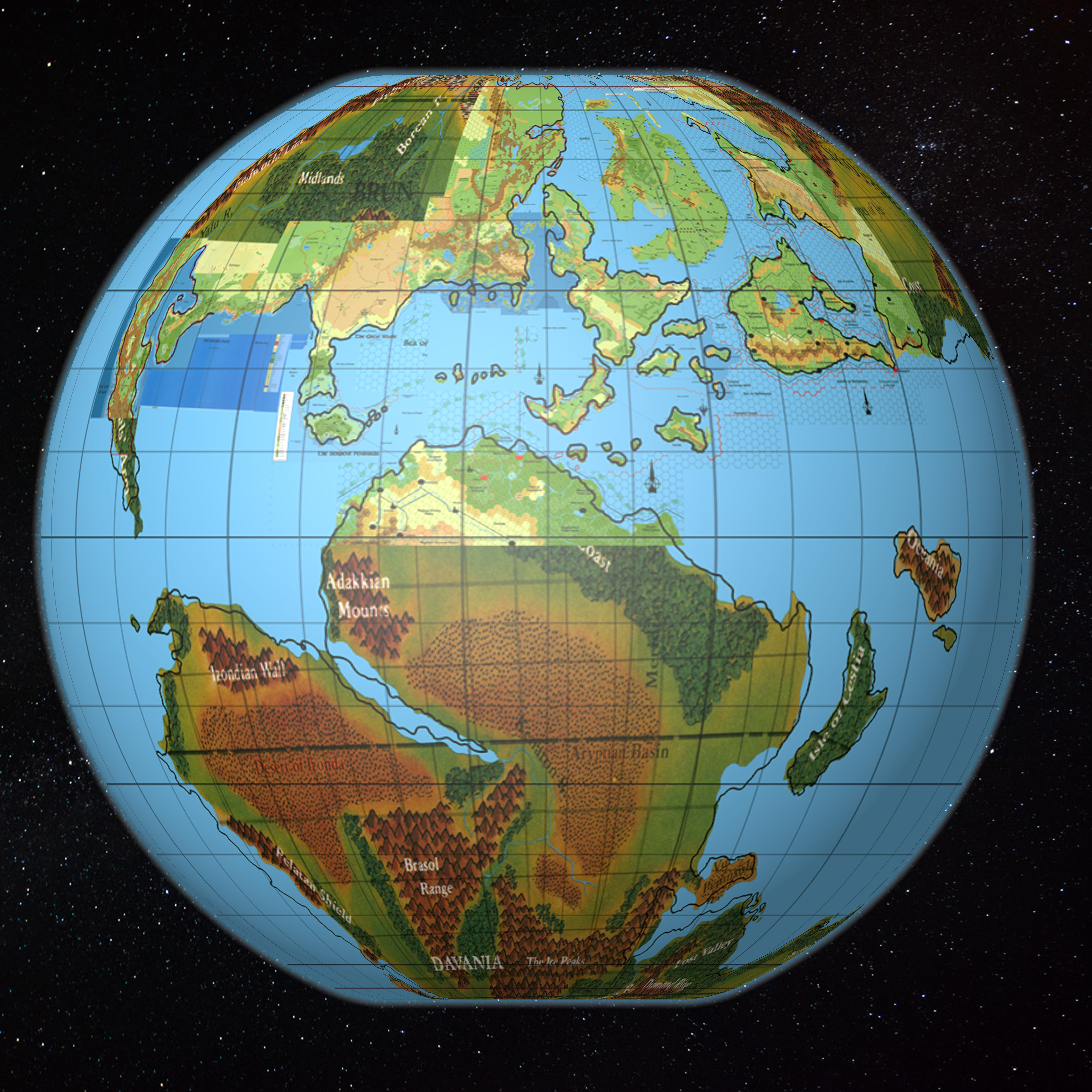
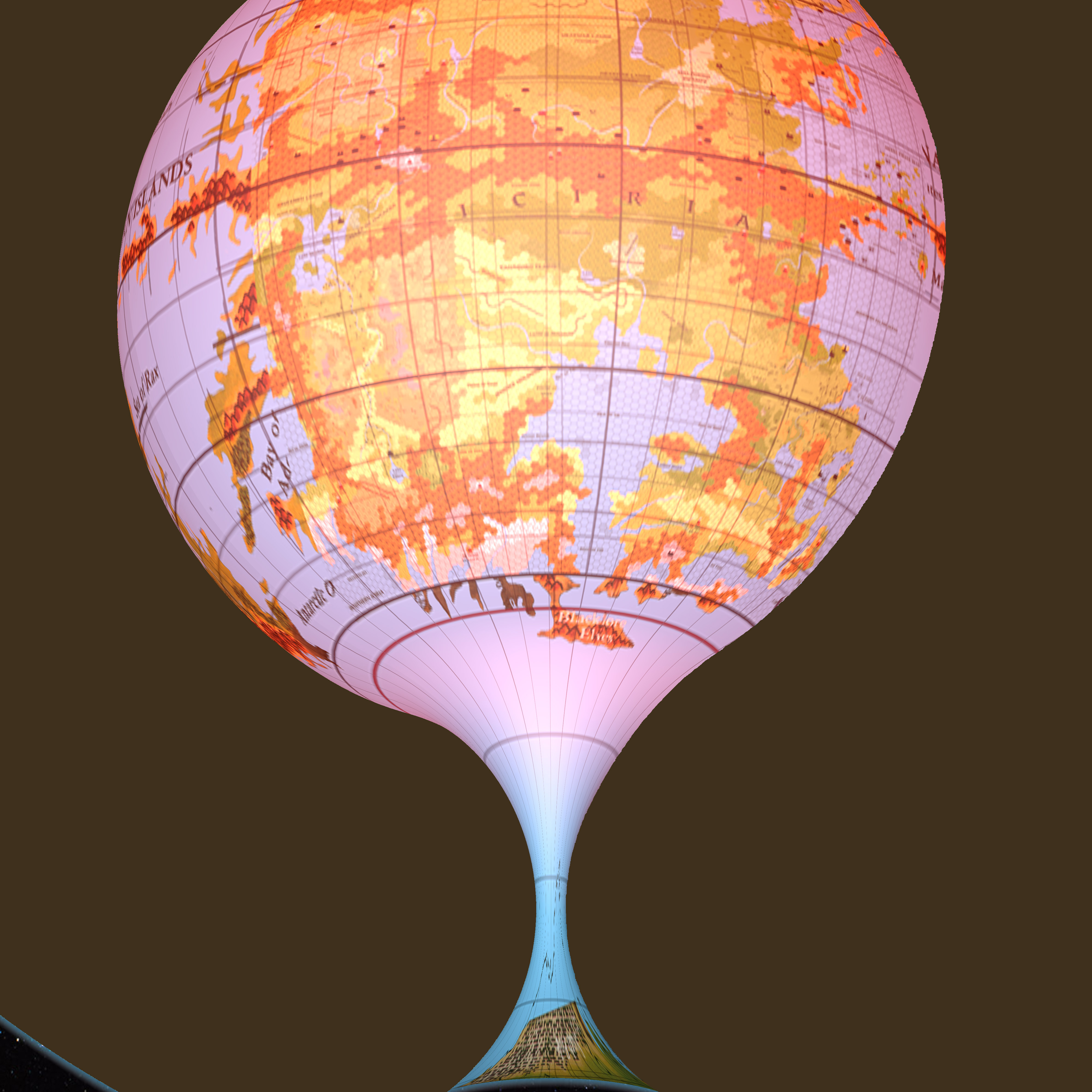
And Davania:
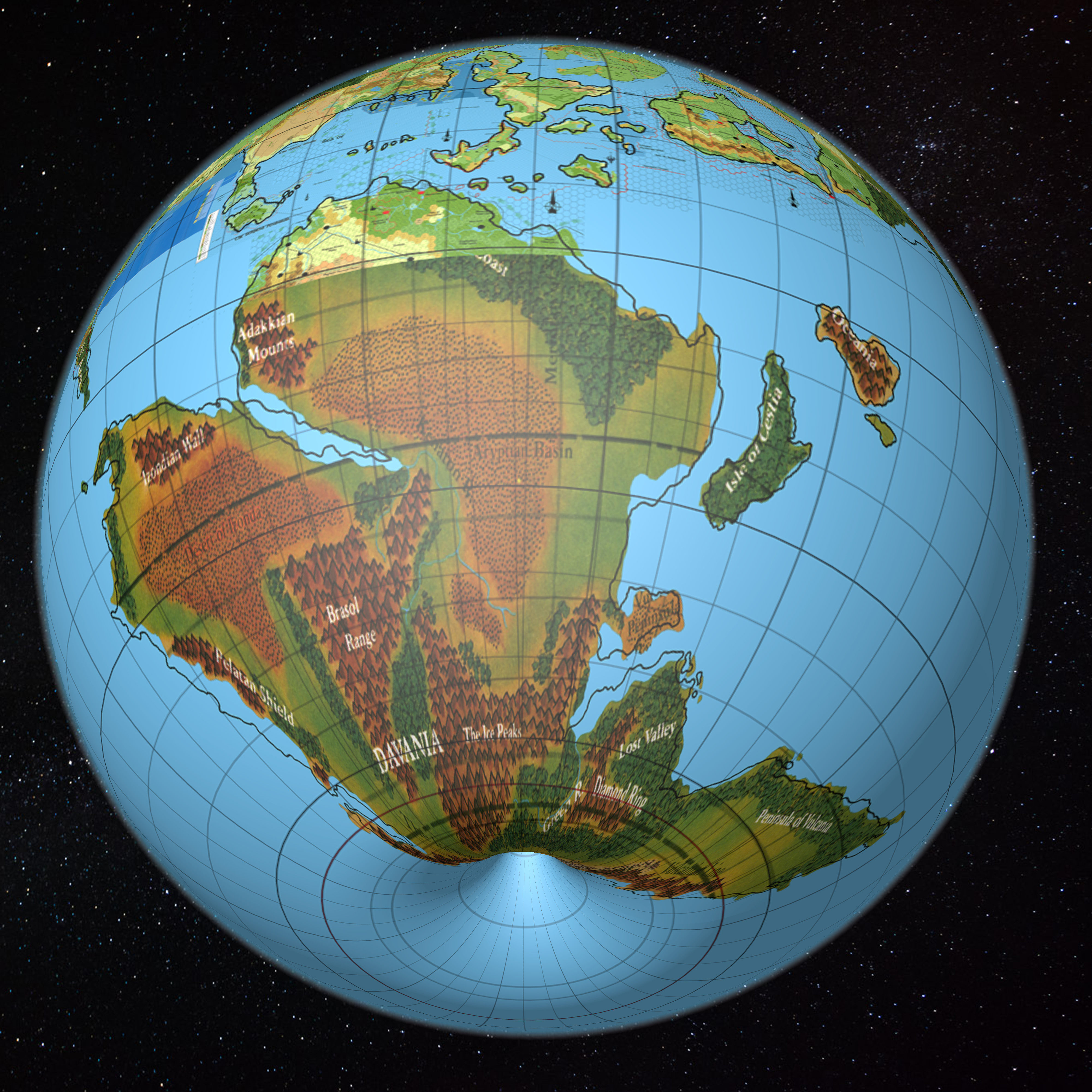
When it’s on the model, Davania is far more visibly South America and Africa with Antarctica and Australia added on. It’s very clear to see in this image.
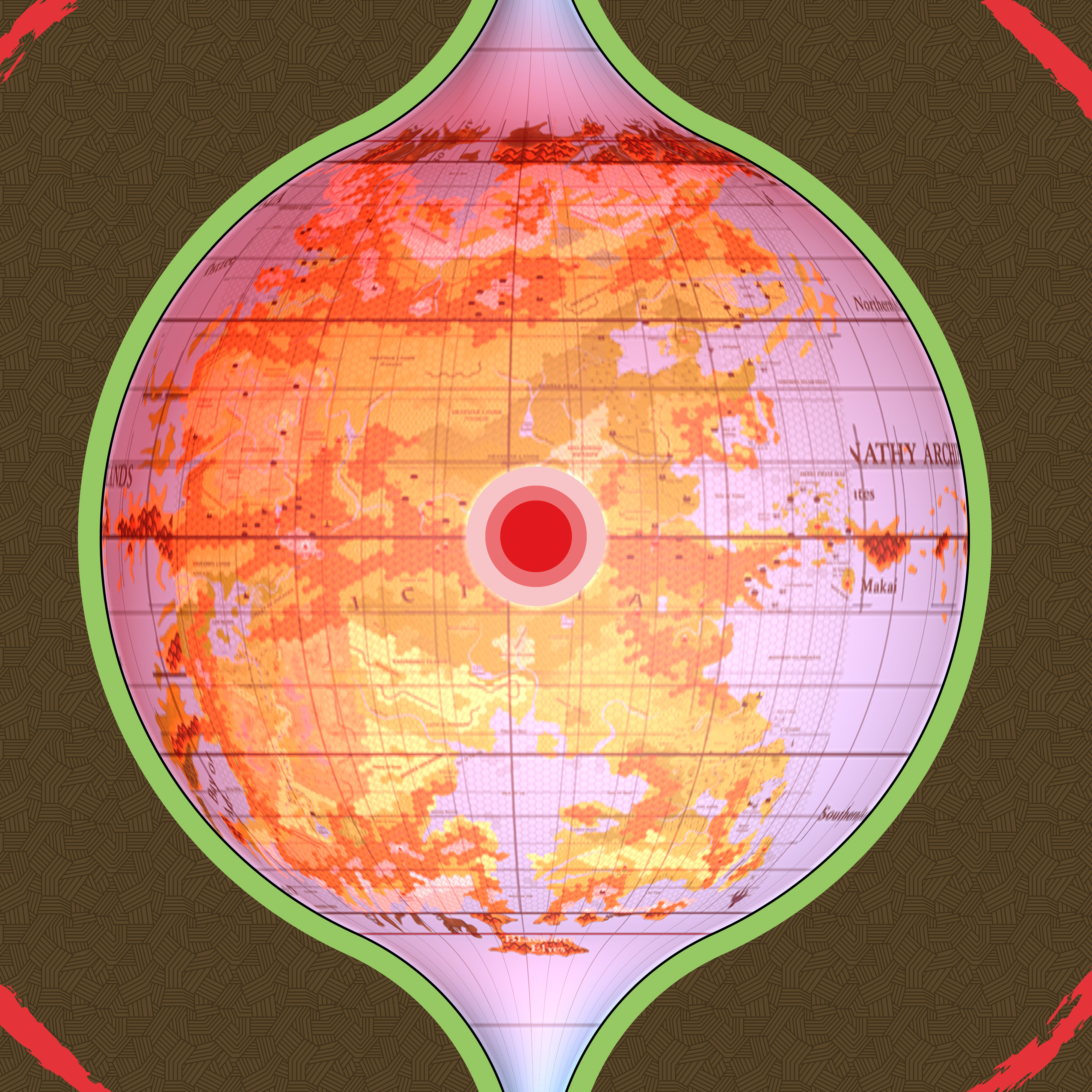
Next, let’s take a look at the polar openings. The north pole:
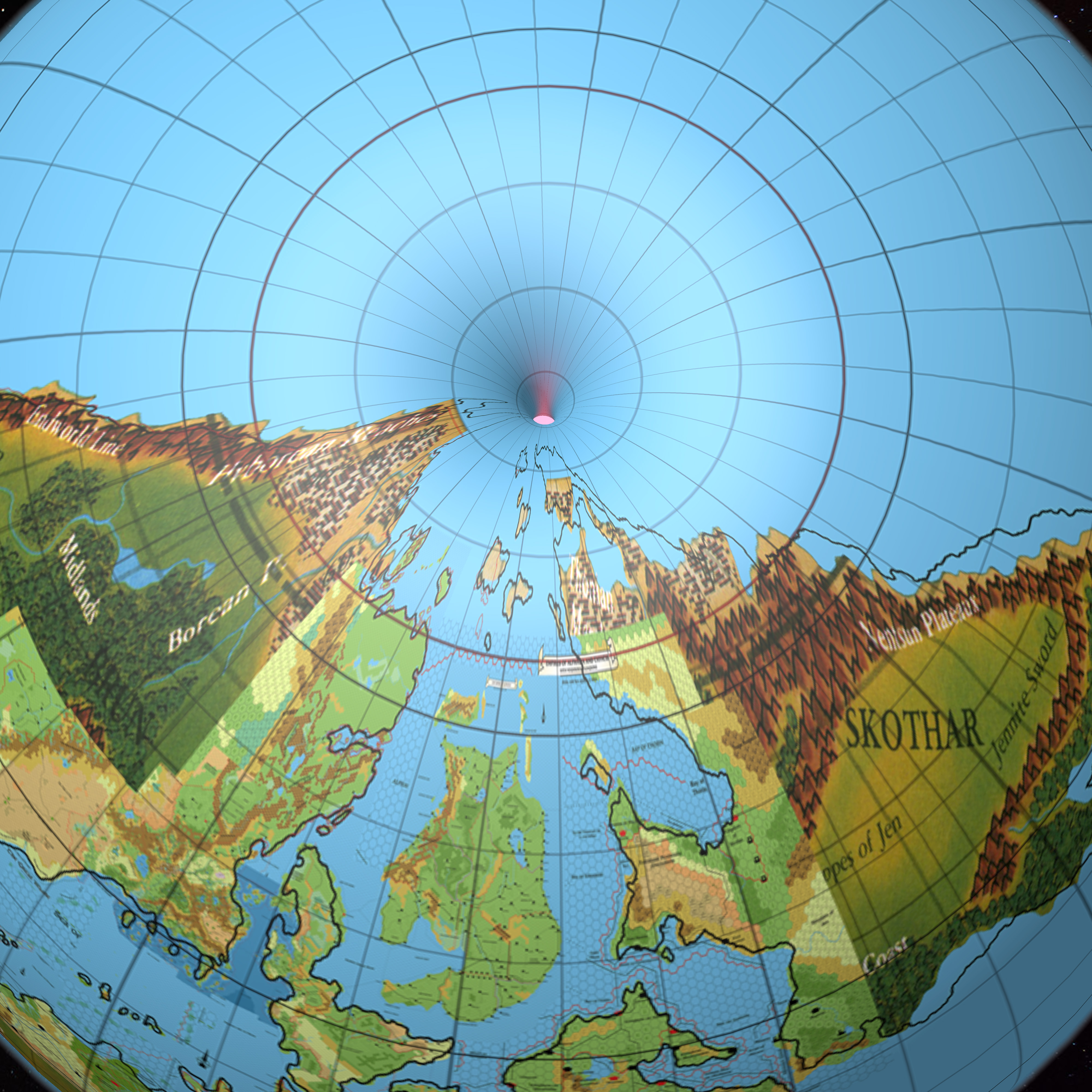
Frosthaven sits just south of absolute north. The composition of the polar opening seems close to the official maps. Note that Nentsun is actually quite small — it’s only marginally larger than Frosthaven in size.
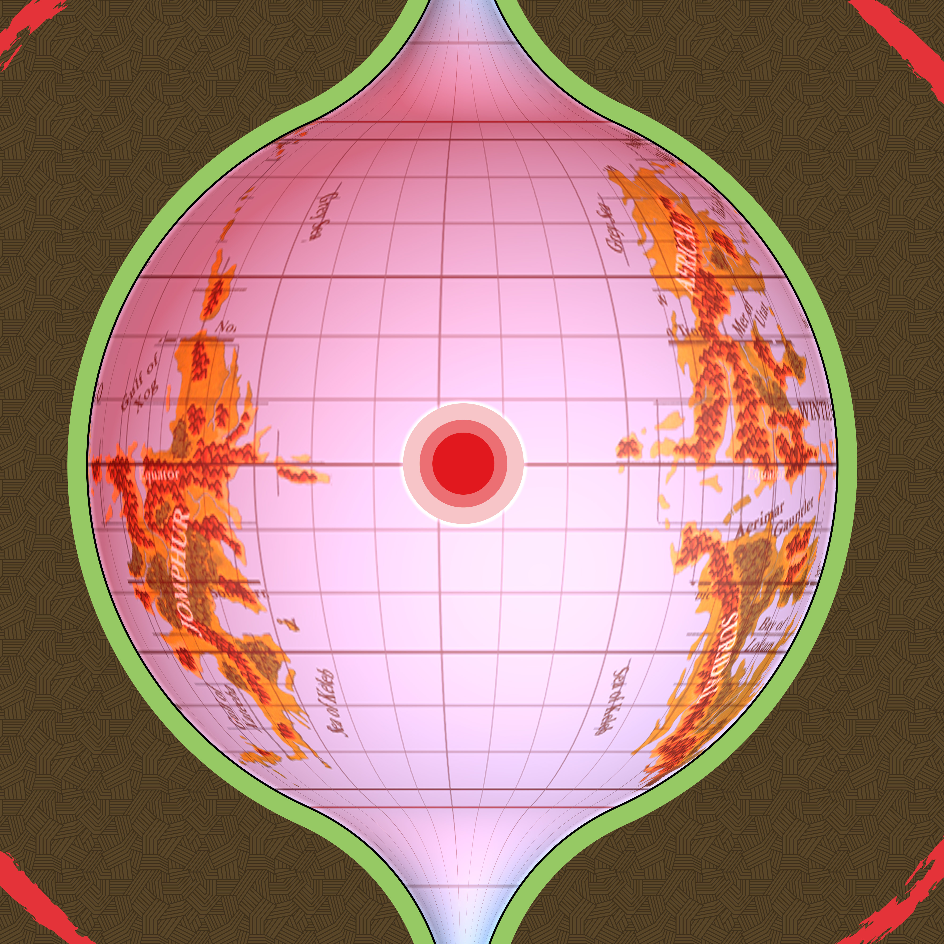
Next, the south pole:
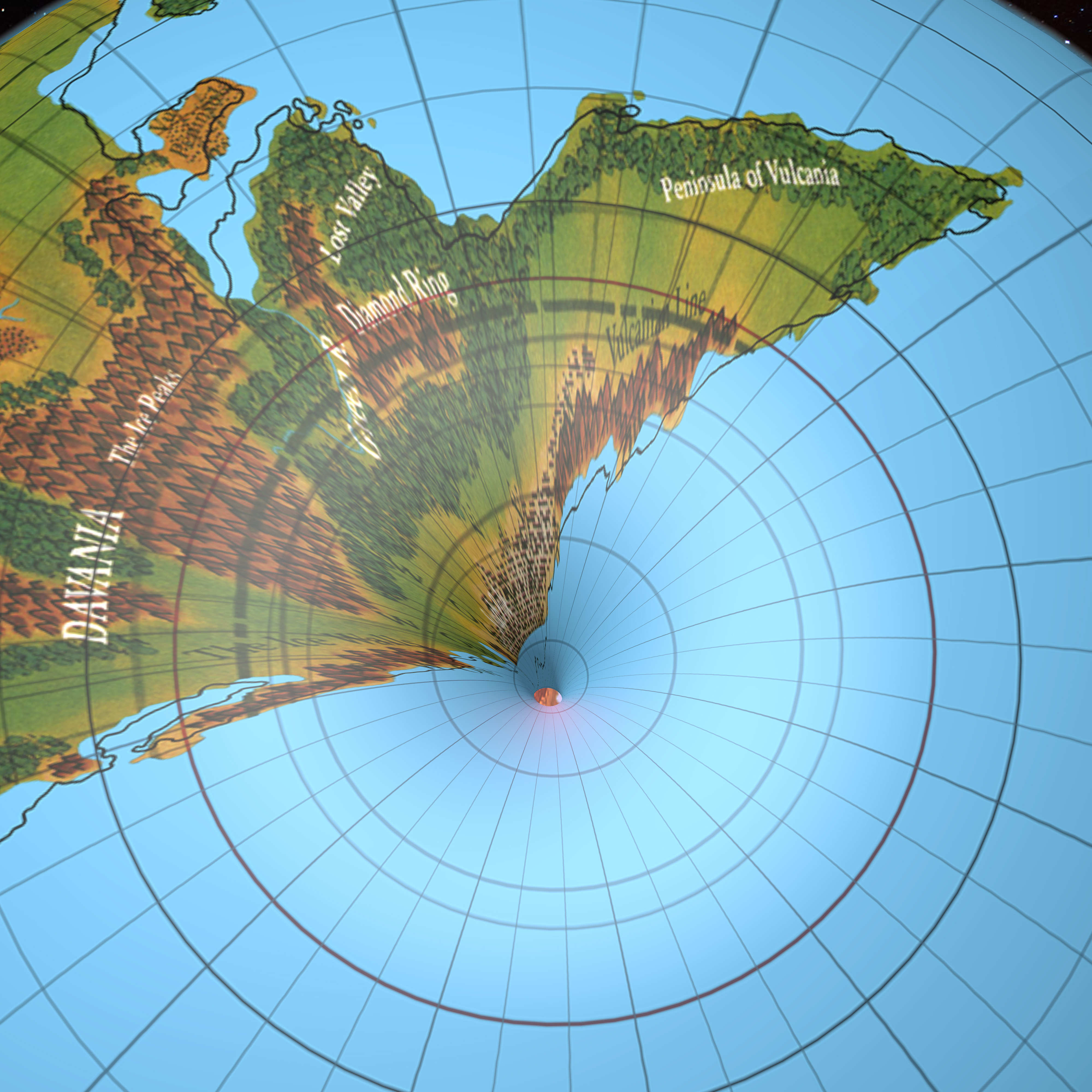
Just the very southern tip of the continent falls into the opening, but it goes about halfway in. As expected, southern Davania is far smaller than it looks on the world maps, due to the pinching effect of the poles, which is lessened on Mystara thanks to the polar openings, but it still significant.
Now let’s delve into the Hollow World. In these shots, you can see the polar openings as well as the Hollow World itself.
The extent of the expanded Grey Sea and Sea of Keleb is apparent in this last one.
Let’s take a closer look.
The fuzziness is because I haven’t rendered these shots, as it takes close to two hours to do so. That can wait for the finished Atlas versions of these maps, hopefully in a few years’ time.
It’s perhaps a little hard to make out how the curvature works here, so let’s try some perspective shots.
The placement of the Hollow World’s landmasses seems pretty good.
Conclusion
I’m quite happy with this model. What do you think?
If you have any feedback, please don’t hold back. Now is the time to iron out any issues.
If nothing major comes up, I will declare the project closed, and all my maps from that point on will use this as the model. Of course there’s a huge amount of work needed to turn these collages back into usable maps, but that is for the next project.


27 February 2016 @ 11:03 pm
AWESOME!!!!
27 February 2016 @ 11:16 pm
Thanks, Geoff! 😀
27 February 2016 @ 11:43 pm
Amazing!
27 February 2016 @ 11:46 pm
Awesome ! I have an algorithm that generate Heigthmaps via Hexmaps… And I can apply these generated heightmaps to a global shape like hollowWorlds, and then navigate through this world… I would like to talk with you about your work.
PS : I’m MyRPG Master Lead Developper.
28 February 2016 @ 1:08 am
That looks and sounds very interesting. It’s definitely a direction I’d like to explore.
28 February 2016 @ 12:06 am
+1 with Geoff on the awesomeness of this.
One question on the sunless areas. How does the daily rotation of the planet affect the sunless area? is most of it only sunless for part of the day (if that makes sense?).
Thanks
28 February 2016 @ 1:13 am
I’m glad you mentioned this, because I noticed that the diagram was missing this info while writing the post, and adjusted it accordingly, but then I forgot to upload the corrected version. It should be there now, so please take another look.
Basically, the immediate area around the entrance to the polar opening up to the narrowest point would be in varying degrees of permanent darkness. There’s also an area that would experience regular day and night cycles in Arctic midsummer, while most of the polar area would be in constant sunlight.
28 February 2016 @ 1:44 am
Very impressive, indeed!
Great work, Thorfinn!
28 February 2016 @ 3:16 am
Nice finished product. I still can’t get past disliking the gross distortion at the highest latitudes. What is your thinking on doing a bit of manual re-aligning to stretch out the land form (where it enters the polar opening) to get the land forms to start looking visually closer to the drawings in the source material?
I don’t think strict adherence to “longitude accuracy” is a priority goal when entering the polar opening. I’d prefer some “cartographic license” in the polar opening when it comes to creating the hex map and get the land up there less squeezed. 😉 Since we don’t have to worry about fitting with new official maps every being made, why not?!
28 February 2016 @ 10:26 am
But distortion at the higher latitudes was always going to be there. Just think about the shape Greenland often appears on maps compared to its actual shape; it’s exactly the same issue.
That said, the land going all spindly and looking thin and stretched is due to the world being designed without this pinching in mind. I will certainly redraw the stuff past 70º to make it look more like we’re used to seeing it. There’s tons of space to work with there, as you say. 🙂
I don’t intend on reworking anything south of 70º, though. I’m quite happy how most of this turned out. For example, Norwold being smaller than the hex maps implied, and northern Alphatia being significantly narrower than southern Alphatia. These are all things that have been staring us in the face for years, but were hidden by the use of the hex format on Equirectangular maps. There’s no way round this, but we’ll always have the old hex maps to use if you don’t like it. 😉
28 February 2016 @ 3:57 am
This is impressive and beautiful. If not for all the monsters, it looks like a place I’d like to visit.
28 February 2016 @ 5:03 am
Beautifully awesome! So much love for all the work and devotion you’ve always put into these maps that have brought Mystara alive for us all! Thank you from me, and now, my children who also play and use your maps!
28 February 2016 @ 2:12 pm
Great work Thorfinn. I am looking forward to the eventual release of the 3D printed Mystara globe. 😉
28 February 2016 @ 7:28 pm
Very, very beautiful. Thanks very much for your efforts in developing this model, Thorf. 🙂
I don’t think I’m exaggerating when I consider this a milestone in the history of Mystara’s fanworks: this is hopefully going to set a consistent reference model on whom future works will be based upon.
I’m looking forward to see you start to refine the regional maps and to sketch the undeveloped areas! 😉
29 February 2016 @ 5:12 pm
High praise indeed! 😀
I wouldn’t want to force my views on anyone else, but I do hope that the outcome is as you suggest. 🙂
Ideas for the last post in the series:
Any other ideas? I’ve no idea when I’d be able to get all these things done, but there’s no hurry, after all. It would be nice to end on a set of preliminary maps.
1 March 2016 @ 10:27 pm
Choosing among your suggestions, I’d go with a quick and dirty version of the Outer World in 72mph (the HW is of lesser concern, IMO). That would by a worthy 20th episode! 🙂
2 March 2016 @ 11:06 am
Overview hex maps would also serve as a base for future maps, which would open up the next project (expanding the world) to Mystara’s other cartographers. A 72 mile per hex map leaves a lot of room for creative interpretation, too, so there’s no need to stress over what to make each symbol, nor even to try to add any detail, as it’s simply not possible at that scale.
This would also allow an enterprising cartographer to make a world-spanning 24 mile per hex map, should anyone be so inclined. 😀
I think I’ll have a go at this. I will definitely do both the Outer World and the Hollow World, though. Aside from anything else, the Hollow World map will be much smaller — although it does need to be completely redone, to present Iciria in an Equirectangular projection to match the Outer World hex maps.
Incidentally, once these maps are done, I can also provide the individual assets for others to use or adapt. The main one really is the coastlines.
29 February 2016 @ 1:01 am
Awesome indeed
Very beautiful.
Personally i would go for a flatter passage between the HW and OW.
Mimicking Polyp structure.
As Mystara is/was a living organism. A Narrow/flatter opening would make more sense in this aspect alone.
as seen in my compilation article http://breathofmystara.blogspot.nl/2013/04/the-megalith-part-2-lesson-by-mergrath.html
that does not mean i disagree with your idea. it is the final result that counts.
and the way you did it…wow
a few steps forward, and we have a planet Mystara, where we cab zoom in to view hex maps, but can be viewed with day night effects, and floating continents and shade effects in the HW.
That would be the Final map…the best as it could be
Respect
29 February 2016 @ 4:59 pm
Thanks, Robin! And thank you for your continuing feedback — I really appreciate it. 🙂
I’m inclined to go with as close a model as possible to the original maps, and leave the rest up to everyone’s imaginations. If my model can serve as a touch-off point for other theories and indeed other models, that is also fine by me. But I feel it’s important to make it as “vanilla” as possible, so that it’s the most useful to the largest number of people.
You’re quite right about the ideal “final map”… There’s still an awful lot of work to do before we can get that far, but this project has finally produced the long-awaited leap past all of the major issues that have been holding us back for so long, which hopefully will make it far clearer what needs to be done.
29 February 2016 @ 2:49 pm
That is pretty awesome, and still leaves a lot of land within the 60 deg band. Too much ice is boring.
But is this really the last post? You mentioned in XII you wanted to sort out the latitudes a & equator before you placed Davania.
29 February 2016 @ 4:49 pm
Davania’s placement was basically dependent on the latitudes and the equator. Sorry if this wasn’t clear. The position I have it in is based on lining up the small corner that appears on Champions of Mystara‘s Serpent Peninsula map with PWA2’s map, then placing the Master Set‘s coastlines to match that. The equator also comes from PWA2, while the latitudes are based on placing Farend at 60ºN.
I will definitely make one last post, but I’m still considering what to do for it. Ending on post XX seems like a nice round figure!
2 March 2016 @ 10:55 am
WOW!!! I Have one busy week and there you go and solve the whole thing!!!
Haha! Fantastic work, Thorf. I started reading the posts right from where I left off and, although it required a lot of concentration to keep up and follow, I think you did an absolute masterful job. I could only agree with you as you went step by step through your process.
So, what’s the next project? World peace, perpetual motion, rationalization of irrational numbers?
It is so wonderful to see you get this completed.
2 March 2016 @ 11:08 am
Thanks, Sheldon! It’s great to see it finally all coming together, after so many years of talking about it! Thanks for all your input over the years. 😉
The next project is to step away from Mystara for a bit, to catch up on other projects I’ve neglected while working on this one — notably Calidar. But I’m also going to do one last article. Currently I’m thinking of presenting overview hex maps of both worlds, at the traditional 72 and 40 miles per hex scales.
7 March 2016 @ 3:39 am
Wow!!!!
28 March 2016 @ 7:35 am
Very cool models. I can’t wait to see what the community creates for more in depth maps based off of this work.
29 March 2016 @ 9:50 am
Wow!
I can’t believe al the time, work, and energy you put into this!
You always do great work!
21 April 2016 @ 3:50 am
Very nicely done. I’m a bit late to the party, having just discovered this fabulous work you’ve been doing. That said, I think there might be one more official map that I didn’t see mentioned anywhere – the Sylvan Realm from CM7. How well does that fit in with the northwest part of Brun?
21 April 2016 @ 5:19 pm
Thanks, Greg!
You have a good point. I overlooked CM7 because I’ve never felt in a position to be able to make a decision yet — but with the whole map pretty much tied down, that is no longer the case.
There may well be another few such stragglers. I will deal with them after I’ve published the final entry to this series, which will present preliminary/rough hex map overviews of the entire planet, likely in 72 miles per hex (40 for the Hollow World).
5 July 2016 @ 3:02 am
Thorfinn,
This is a great work, man! Awesome, indeed! We could finally have a “google street view” for a RPG campaign scenario!
Contratulations, I really think that you stablished a landmark on things here!
E.
5 March 2017 @ 1:06 am
Just fantastically perfectly awesome!
20 March 2017 @ 1:43 am
That’s some amazing work.
Lining Up Mystara Revisited – Thorfinn Tait Cartography
17 February 2018 @ 9:01 pm
[…] around this time two years ago, I finished my Lining Up Mystara project, winding up 11 years of attempts to reconcile all of Mystara’s officially published maps into a […]
Lining Up Mystara Revisited II – Thorfinn Tait Cartography
1 March 2018 @ 9:25 pm
[…] be georegistered. This means matching up the coastlines of the Master Set world map — or indeed my 2016 model — to the Jurassic Earth map as closely as possible. With the coastlines in place, we can lock in […]
Lining Up Mystara Revisited IV – Thorfinn Tait Cartography
13 June 2019 @ 8:48 pm
[…] some discussion in the Mystara Cartographic Society on Facebook, I decided to keep my 2016 model’s hex map-based coastlines. The match with the Jurassic Earth map is really not tight enough to […]