Skothar Continental Hex Map
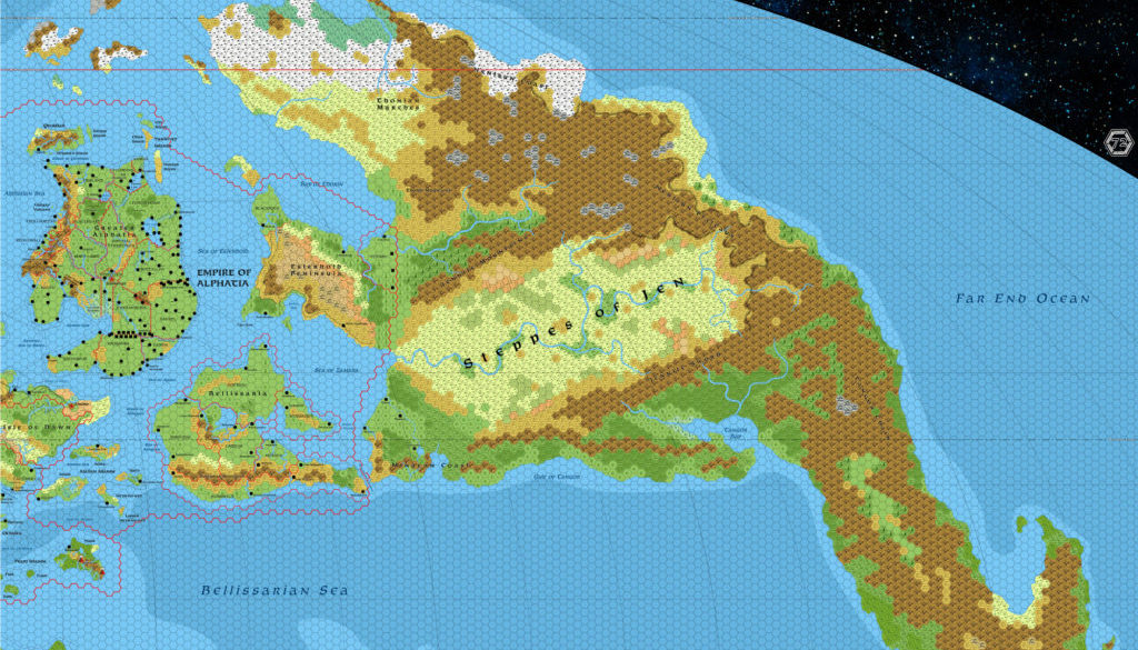
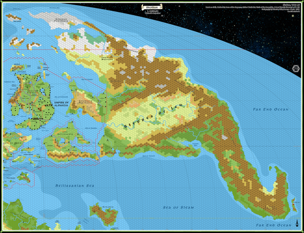
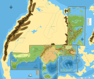
The first of the continental hex maps is finished. Presenting:
Skothar, 72 miles per hex
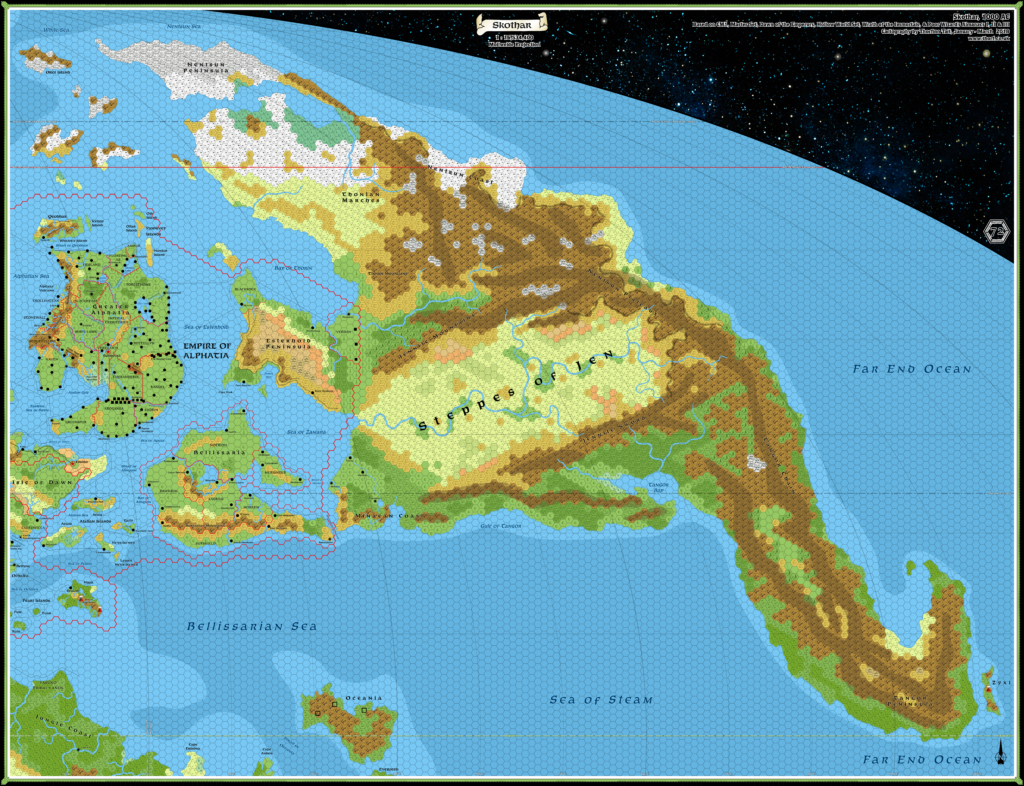
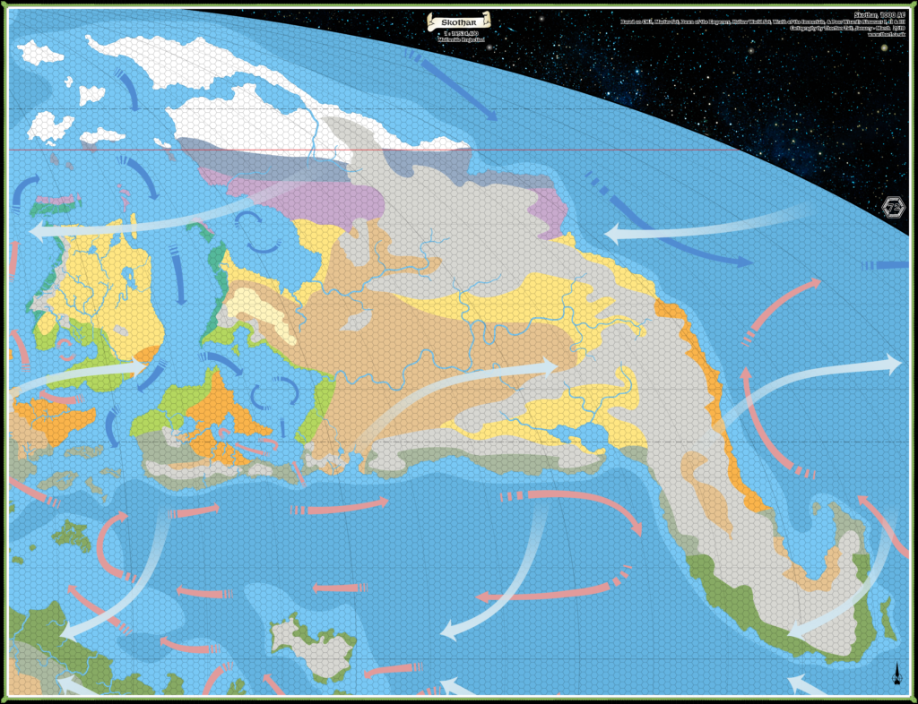
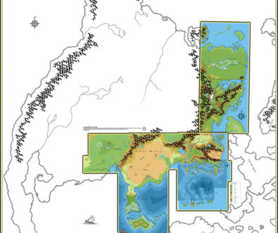
Note: These maps are huge. If you have problems, please try using these direct links: Skothar map, Skothar map with ridges, Skothar climate map. Try right clicking and choosing “Save Linked Image” (or the equivalent) rather than just clicking.
This is a first draft, and at 72 miles per hex it’s also rather small scale. Which is to say, almost everything is still open for change.
I’ve redone areas that appeared on 24 mile per hex maps to more closely match those maps. For example, Nuar in the Pearl Islands is completely different from how it appeared on previous 72 mile per hex maps; it’s far more accurate.
I derived the terrain in previously unmapped regions from five main sources:
- The Master Rules Set world map
- The Jurassic Earth map
- The Hollow World Campaign Set world map
- My climate map for Mystara, which is an expanded version of Bruce Heard’s climate map of Brun
- Previous fan-made maps, such as Thibault Sarlat’s and Francesco Defferrari’s
The mountains come primarily from the base Master Set world map. I then referenced the Jurassic Earth map to get information on the ridges. Here’s a variant of the map with the ridges overlaid:
You can see the ridges in dark brown.
The continental shelves come from the same map, as no official maps ever gave ocean depths for any of these regions.
The Hollow World Set map shows all the terrain in very broad strokes. I adapted this to get the forests, hills, tundra/snow fields, and plains. I referred to my climate map for guidance while doing this.
Finally, I tried to reference the fan-made maps as much as I could, but this was made rather difficult by the rather drastic difference in Skothar’s shape. As a result, I haven’t incorporated nearly as much detail as I would have liked, and instead went for similar overall patterns and inspiration rather than copying specific detail.
Upgrades
As I said, this is just the first draft. I’d love to hear your thoughts on the map: what did I get right, what did I get wrong, etc. I’m happy to change terrain details to accommodate existing or new fan projects; nothing east of 30ºE is set in stone, as most of it is just arbitrary decisions.
So please don’t hesitate to get in touch if you have any comments, suggestions, or corrections!
Back to work… This is just the first of three (four?!), after all…
7 March 2018 @ 11:59 pm
The maps look awesome. The climate map is near identical like the one I work on (as agreed).
I have to check in detail…however I get a 504 gateway timeout each time I try to click on the maps themselves.
So this I have to do later.
I searched and located some old maps of mine in my compilation/creation archive and two maps in my beholder research are detailed on Skothar.
https://6inchnails.deviantart.com/art/Skothar-Kargash-beholder-city-734325625
and
https://6inchnails.deviantart.com/art/beholderbreeds-on-Mystara-and-their-cities-734325158
keep in mind that Beholder borders do not follow any other borders.
I used the maps of Wombat (http://www.thekeep.org/~wombat/Mystara/FrenchSiteMaps/) to make the Kargash location maps. the names of the areas are created by me.
Maybe these are of some use to you
22 March 2018 @ 9:24 am
Hi Robin!
Did you manage to download the files? I sometimes have problems getting larger files, too. It often helps to right click and choose “Save link as…” or the equivalent in your browser.
Thanks for the Kargash links, by the way. I’m a big fan of beholders, so it’s always fun to see more development there. Do you feel that my present map leaves room for you to place Kargash? Although I’m not adding fan-made areas at this point, I’m happy to add in the right terrain to accommodate them — after all, a lot of this terrain is quite arbitrary, especially when it comes to the individual hex choices.
8 April 2019 @ 2:19 am
Hi Thorf
Completely overseen your comment. so sorry
Here my (late) reaction ;S
After several tries and PC’s which went awry, restarting and indeed the method of “Save link as…” was fruitful 😉
As far as I see you could place Kargash without too much troubles. I created the location based fully on the canon map of Skothar, and first then added textures based on fanon as explained in the text. So the contours and general locations are as canon, detailing is fan based but self created based on the former sources as can best be seen in the first link I gave.
And I like Beholders too…I am working already 4 years off-and-on making a life-sized Con costume of a Beholder which I intend to wear at Castlefest/Elf Fantasy Fair in the Netherlands. And yes when ready I will make pictures and share them on Piazza 😉
Greets
Robin
8 March 2018 @ 3:32 am
Wonderful work, Thorf. I like very much the way Skothar turned out. There are a couple of very long rivers that could represent interesting features for future developments – in particular those flowing to Faraway and through the Steppes of Jen, which are natural and seemingly very profitable trade routes to Skothar’s interior.
Some minor comments on the map:
– I suppose you prefer calling them “northern” and “southern” tropics for ease of reference, but on Mystara they should become (according to Mystaran zodiac signs as shows in the PWAs) respectively the Gorgon Tropic and the Giant Tropic – at least in KW standards.
– Glaciers: I see you put a great number of them in Skotharian ranges, which is ok for me, but aren’t some of them a little too large? I mean, the largest glaciers on Earth don’t exceed 50 miles of lenght… Now it’s true that if Mystara’s climate is colder, glaciers in Skothar’s northern massif (which supposedly has a high altitude) could be larger as well, but some of those featured in the map are truly huge indeed.
– Esterhold: Rock Harbor, being a “harbor”, shouldn’t be found on the coast?
[The following comments aren’t really about Skothar, but regard the part of the Alphatian Sea region shown on the map.]
– Alphatia: I suspect some area here will need to be redone to adapt old 72mph maps to known 24mph terrain, just like what you did with Nuar; in particular, Shiye-Lawr is almost totally heavy forest in DotE’s 24mph map of Alphatia, while here it appears lightly wooded. Maybe – if this fits your project – a (future) effort could be made to incorporate in these 72mph maps the “new” maps (at 8mph) done by Bruce for the detailed Alphatian realms on his blog.
– Bellissaria: Alchemos and Blueside should be cities, not towns.
– Isle of Dawn: Ekto, regardless of what is shown on the 24mph maps, should be located on the coast of the 72m hex to the south-west of the one where the city is now; this is clear in the accurate description of the city’s position from PWAII (pages 219-220, event “Thyatis Fortifies Ekto” on Svifmont 1: “Ekto commands a narrow bay that opens onto the Eastern Sea of Dawn, and guards the only safe routes overland to East Portage or the Fortress of Kendach. Mountains protect the city’s western flank, and level farmlands to the south and east offer advancing armies little cover”).
Both Trikelios and Ekto, on the map, should be cities, not towns. Edairo should be featured as a simple city, not a capital – unless all other capitals of the Alphatian subject realms are likewise shown with the capital red symbol.
Lastly, the political borders on the Isle of Dawn, drawn from the PWAs maps, are inaccurate if confronted with 24mph maps of the same region, since they follow the border of 72m hexes and go largely out of place. Maybe later an adaptation of these borders to the 24mph ones (like you did with Alphatia) could be worth an effort.
Regarding fan works, the only mapped ones are those you already mentioned AFAIK, with the addition of Calengaer – which could be found in any one forested hex north of the Jennite Mountains, or added as one forested hex in place of one of the hill hexes in the north-eastern part of that river valley.
Excellent work so far! 🙂
8 March 2018 @ 5:48 am
@ Simone
…..but on Mystara they should become (according to Mystaran zodiac signs as shows in the PWAs) respectively the Gorgon Tropic and the Giant Tropic – at least in KW standards…..
excellent idea….did you pick these from the same zodiac order and location as the real world designations? or did you use a similar approach as the real world (https://www.thoughtco.com/tropic-of-cancer-tropic-of-capricorn-3976951)did use to get these designations…which on Mystara might resolve in a different than just copy/locate/translate to Mystara system)
9 March 2018 @ 12:06 am
@ Robin: Of course, I simply translated Cancer with Gorgon, and Capricorn with Giant – since they happen to be in the same order in the two zodiacal systems. So, I didn’t embark in any further astronomical calculation, sorry! 😉
9 March 2018 @ 10:24 pm
Thanks for the great feedback, Simone!
The rivers seemed inevitable, given the terrain. The exact courses are up for debate, of course — they’re pretty random as it is — but their existence seems indisputable.
The Faraway river is slightly problematic in that it wasn’t shown on official maps, but again it seems like the best spot for drainage of that region, and really there must be at least a small river there, or they wouldn’t have chosen that spot for the town.
The Tropics — actually, I was sure that we already had names for these, but I couldn’t find them anywhere. No matter how many maps I looked at, all that was coming up was Northern Tropic and Southern Tropic. Didn’t an official map name these at one stage? Am I perhaps thinking of Calidar, in which Bruce definitely named the Tropics?! I was sure Mystara had names already too…
So yes, I’m all for naming them. However… Although Tropic of Gorgon sounds great, Tropic of Giant sounds a bit silly.
For the glaciers, it’s perhaps worth remembering that although these look like huge blocks at this scale, they may actually be far smaller. It’s a limitation of the scale. But really they’re just there to try to break up the huge blocks of mountains a little. My hope is that people will work on 24 and 8 mile per hex maps and refine my very rough choices. Once that happens, this map can be revised as necessary. This process of revision is sort of a Mystara tradition, don’t you think?
That said, do you have any other ideas to break the mountain blocks up? I must admit, I’m considering making a slightly darker mountain hex to mark the ridges, as that seems to have been very popular, and it does help to see the shape of the mountains better.
Rock Harbour — good catch, I’ll move it to the coast. This is why I’m using the smaller symbols — and why I think they are probably best used at 24 miles per hex, too, since it allows the exact location of the settlements to be shown as per their 8 mile per hex position.
Alphatia — for some reason I thought I had redone it, but I guess not. You’re right, it definitely needs work! I have also yet to clean up the smaller settlement labels, of which there are far too many.
For populations, I’ve been slowly inputting the numbers, along with page references for their sources. Of course this is not visible on the map, but I can export this to a spreadsheet and then manipulate things there. That can in turn be imported back into the map file, at which point I can now create a link between Excel and the map in Illustrator, and automatically reflect edits to the sheet back to the map. This is very exciting stuff! For the same reason, I’ve put a call out for Mystara spreadsheets people may have lurking on their hard disks, as I can now place this info in the map using this technique.
And the info in the map can eventually be leveraged into a web map.
What do you think about the 24 mile per hex-based borders? I’m not sure what to do here. I guess I could simplify them to remove the hex shapes, so that they all look like those of Shiye Lawr. Dawn of the Emperors actually did this for the Known World. It’s probably the best solution.
By the way, I’m saving the Isle of Dawn for the Brun map, since only a fragment of it appears here.
Thanks for all the other suggestions! Much appreciated.
10 March 2018 @ 6:47 pm
Good point regarding glaciers; I had not considered the possibility that those “blocks” of glacier hexes could actually be split into some smaller, glaciers.
About the Tropics, they were never named in official products as far as I recall; following LoZompatore, I use the names of the RW-corresponding star signs – the Gorgon and the Giant. As Robin pointed out, maybe some astronomical calculation involving Mystara’s axial tilt could produce a better choice among the 12 Mystaran star signs as shown on the PWAs. Otherwise, one could use elven names of the corresponding star signs – which would be the Warrior and the Narwhal (from CM7 and http://pandius.com/zodmoons.html).
I have no particular idea to break the mountain blocks up… Using glacier and hill hexes is the natural and most obvious choice, as you already did; introducing too many of them in a 72mph map could however lead to some terrain distortion in the larger-scale maps, if you understand what I mean – a 72m valley is a quite large region, so I’d avoid overdoing with them, at least until fan works would have better detailed these areas (for example, Giulio Caroletti’s Nentsun mapless gazetteer could be used in the future to produce a more detailed map of the Nentsun Plateaux which could in turn have consequences on the 72mph map; the same happened with Bruce’s new 8mph maps of the Alphatian realms in regard to DotE’s 24mps map.
Marking the mountain ridges is a good idea, and something which is very useful at any map scale. In my home maps I tend to use the “volcanic formation” symbol from PC4 to mark the ridges, but at the 72mph scale this symbol might seem exceeding. So using a mountain hex in a darker shade of brown to mark the ridges is really a good idea.
What you say about the link between the population spreadsheet and the map is really intriguing! The prospect to have a future Mystara web map is fantastic! I had seen your call for spreadsheet on the FB page: since I’m by nature a maniacal data compilator, I’m happy to lend you a hand here if you need; if you tell me which data you need and which canon sources you have (or you still haven’t) surveyed, I can start a data-gathering consistent with yours. After all, having a sheet with official population figures available all in one place is a useful tool anyway.
About the 24 mile per hex-based borders, having them without the hex shapes is certainly better from an esthetic point of view, even if the hex shapes would still remain in place for the 72mph based borders, whose redrawing would be quite random, so I’d not bother too much about that since you will still end up with a map which has both hex-shaped and non-hex-shaped borders. On the other hand, one thing I don’t find neither useful nor nice to behold is the fact that some Alphatian realms (Verdan, Bellissarian kingdoms) have borders marking their own maritime areas (if such concept might exist at all in a Late Middle Age fantasy world), while many others have not; personally, I’d only keep the Alphatian Empire’s sea borders and skip the subject realms’ ones (which I suppose are coming from the PWAs, whose maps refer to a time – AC 1010 onwards – when such realms were independent).
8 March 2018 @ 5:21 am
Excellent work Thorf! I was anticipating a 72 mile hex map which would replicate the terrain shown on the HW map, but it appears you’ve added much more detail than that which is really useful.
My only suggestion would be to add some forested regions on or near the Thonian Marches. Boreal forest is the largest biome in the real world with the exception of the oceans, and Wikipedia has an interesting map showing the large area that it covers – please see here:
https://en.wikipedia.org/wiki/Taiga
I therefore think it likely that forested areas would be present near the tundra terrain around the Thonian Marches, or alternatively, in the area immediately to the west. These forests do grow quite far north, and often actually border the tundra regions, where the land then becomes dominated by arctic grasslands.
That’s the only suggestion that I have!
Regards,
Matt
9 March 2018 @ 10:32 am
Thanks, Matt!
Just using the terrain from the Hollow World Set map left things looking far too bare, so I decided to expand on it a bit — with the caveat that everything at this scale is just “guidelines” anyway.
You raise a very good point here about taiga. This is something we are really missing symbols for.
Actually, I’d love to have a wide-ranging discussion about hex symbols, and define exactly what we mean by them while revising and expanding them to cover all the major and most of the minor (and indeed fantasy) biomes. For now, I’ve been working mostly within TSR’s set, and my interpretation of the northern areas of the world is largely based on how similar latitudes of the Hollow World appeared in official maps.
Another thing that would help immensely here is a simple biome map, halfway between full terrain hexes and the climate map. I already made mock-ups like this for Skothar and Davania to help make these maps.
I’m going to have another look at the biome spread and compare it with real world biome distribution.