
Let’s Map Mystara 1981 II
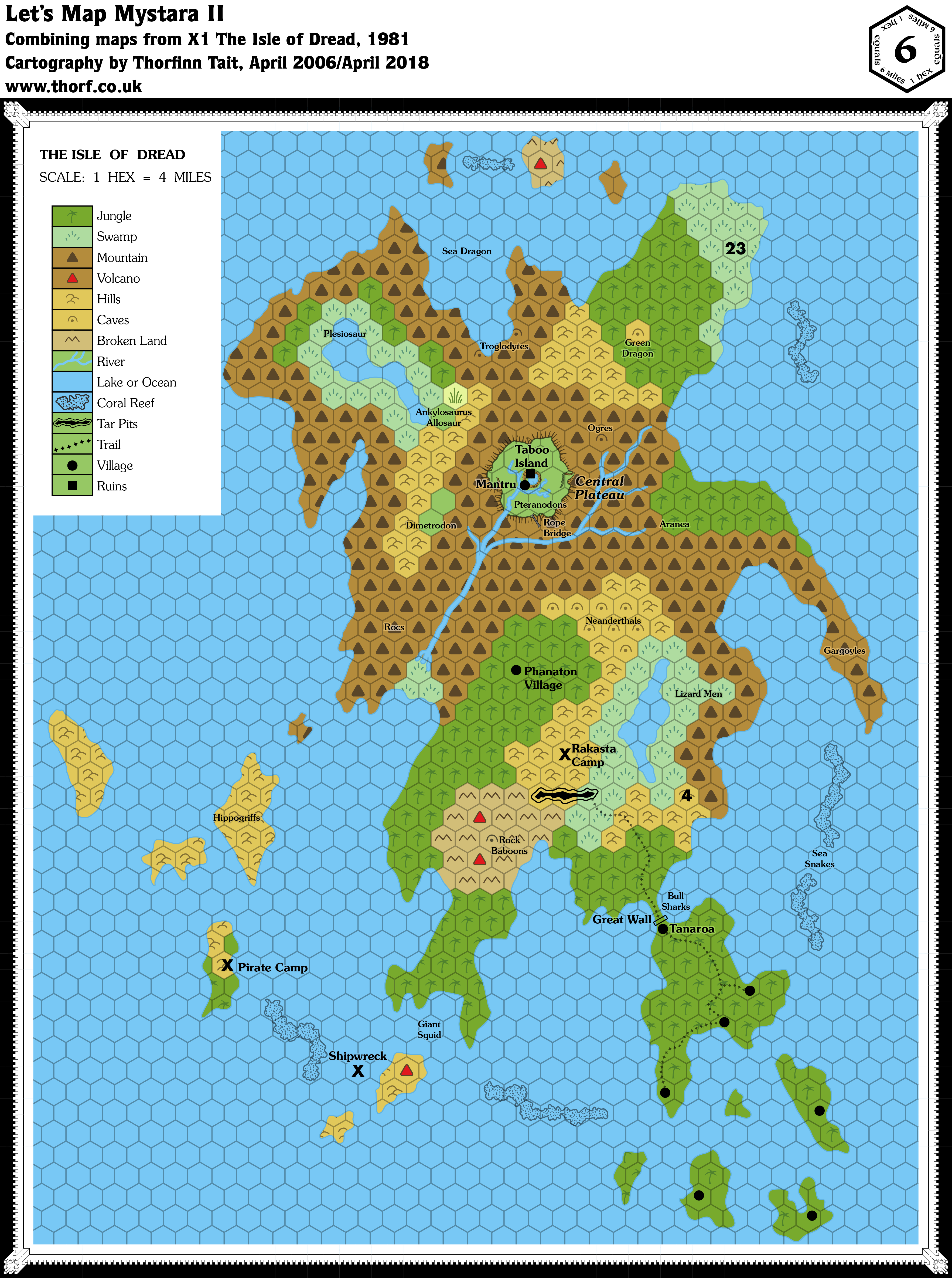
Map 2: “Isle of Dread” from X1 (1981)
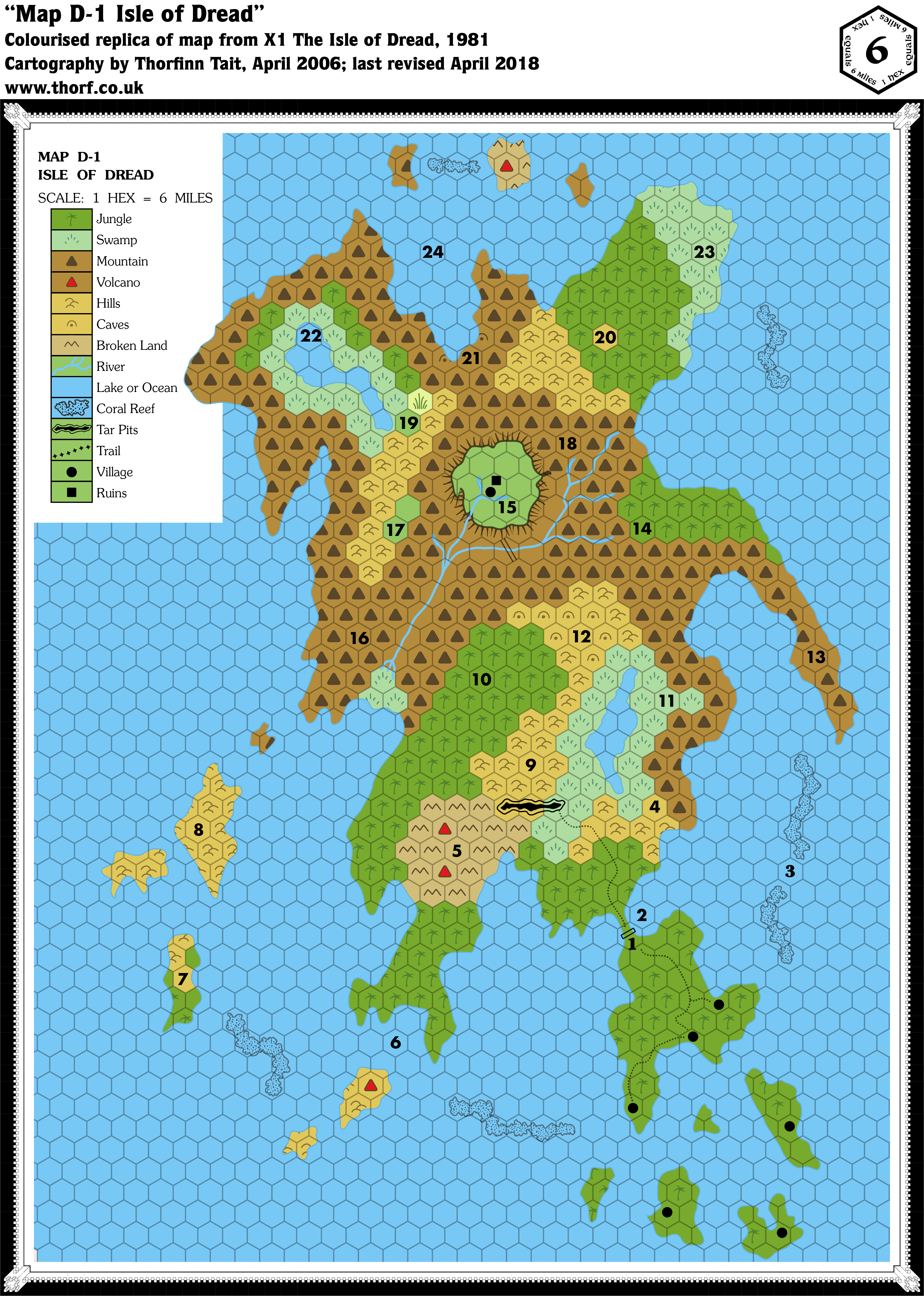
Including Map 2a, the player’s map of the Isle of Dread, which is a variant of this map.
From the Atlas of Mystara:
X1 contains not one but two iconic Mystara maps. This is the original Isle of Dread map.
The map itself used horizontal rather than vertical columns of hexes, but since nothing around it was ever mapped, this doesn’t really pose a great problem. Much more problematic is the scale, and it has become common knowledge in the Mystara community that the map needs to be interpreted as 4 miles per hex in order to get it to match with the size of the Isle as shown on the 24 mile per hex map. The alternative — rescaling the 24 mile per hex map’s Isle to match the 6 mile per hex scale — would put the Isle of Dread out of scale with the other islands in the Thanegioth Archipelago, although it’s an equally valid solution.
Additions
- Bridge — a rope bridge crosses the central river.
- Islands — fourteen small islands dotted around the Isle of Dread.
- Lakes — two lakes on the Isle of Dread.
- Plateaus — the Central Plateau.
- Reefs — six long reefs between the islands.
- Rivers — a single river network originating on the plateau and in the mountains to its east, flowing down to the swamp.
- Settlements — six villages are marked in the southeast of the map, with another on the Central Plateau next to some ruins. One more is marked only on the players’ map, although it does appear as a “1” label on the main map.
- Terrain — the overall terrain is somewhat different from the 24 mile hex map, as is to be expected when converting to larger scale. Lots of detail has been added, including tar pits, and reefs round the coast.
- Trails — a single trail network links three villages on the southeastern peninsula with the wall before continuing on to the tar pit.
Revisions
- Coastline — the Isle of Dread is significantly bigger on the larger scale map. It retains the same overall shape, but is much wider east to west, with lots of added detail all round the coast.
- Islands — the small island to the immediate west of the Isle of Dread should appear on this map, but was omitted. Given the differing shape of the Isle of Dread between maps, this was likely an oversight.
- Scale — at the printed scale (6 miles per hex), the Isle of Dread would be much bigger than the 24 mile per hex map shows. As the quote from the Atlas noted, there are two possible solutions to this: either change the scale of the Isle of Dread map, or increase the size of the Isle on the 24 mile per hex map. I have chosen to change the scale.
Hex Art
- Fonts — Souvenir for titling and legend; Futura for keyed numbers.
- New Symbols — Caves (dot inside upside-down U shape), Coral Reef (black shapes in the sea), Tar Pits (black shape surrounded by offset black outline), Village (filled circle), Ruins (filled square).
Textual Additions (X1 1981)
- Altitude — the Central Plateau is 3,000′ high. (p. 12)
- Bridge — the rope bridge is said to be 300′ long. (p. 10) It’s also said to be one of the three ways to gain access to the central plateau. (p. 12)
- Fauna — bull sharks at 2, sea snakes at 3, rock baboons at 5, giant squid at 6 (all p. 8); hippogriffs at 8 (p. 9); lizard men at 11, neanderthals at 12, gargoyles at 13, aranea at 14, pteranodons at 15, rocs at 16 (p. 10); dimetrodon at 17, ogres at 18, ankylosaurus and allosaur at 19, green dragon at 20, troglodytes at 21, plesiosaur at 22, sea dragon at 24 (all p. 11).
- Government — the seven villages of the Isle of Dread are matriarchies. (p. 7)
- Key — the text provides details for the numbers marked on the map. (p. 7-11) These have been detailed in the appropriate categories in this list.
- Settlements — the 1 on the map indicates the village of Tanaroa; the players’ map actually shows it as an icon, too. (p. 7, 32) “The other villages are Kirikura, Dawa, Mora, Panitube, Burowao, and Usi.” (p. 7) Unfortunately the text doesn’t state which village is which. “The population of all seven villages is about 2100 total.” (p. 7) Since all the villages use the same map, it makes sense to consider that they each have roughly the same population, meaning that each village has about 300 inhabitants. 7 is a pirate camp, population 41. (p. 8) 9 is a rakasta camp, population 19. (p. 9) Since we don’t have an icon for camps yet, they have been marked with X for now. 10 is a phanaton village, population 100. (p. 9)
- Shipwreck — described under “Sunken Treasure” as “on the southwestern side, between the smoking mountains and the reef”. (p. 27) For lack of a symbol, this has been temporarily marked with an X.
- Terrain — caves at 5 (p. 8), 12 (p. 10), 18 and 20 (p. 11). The terrain type for these caves is usually noted in the text. Many hexes were left blank for clarity on the black and white map; these have been extrapolated from surrounding terrain and added. The green dragon’s lair at 20 has been marked as a hills hex (p. 11).
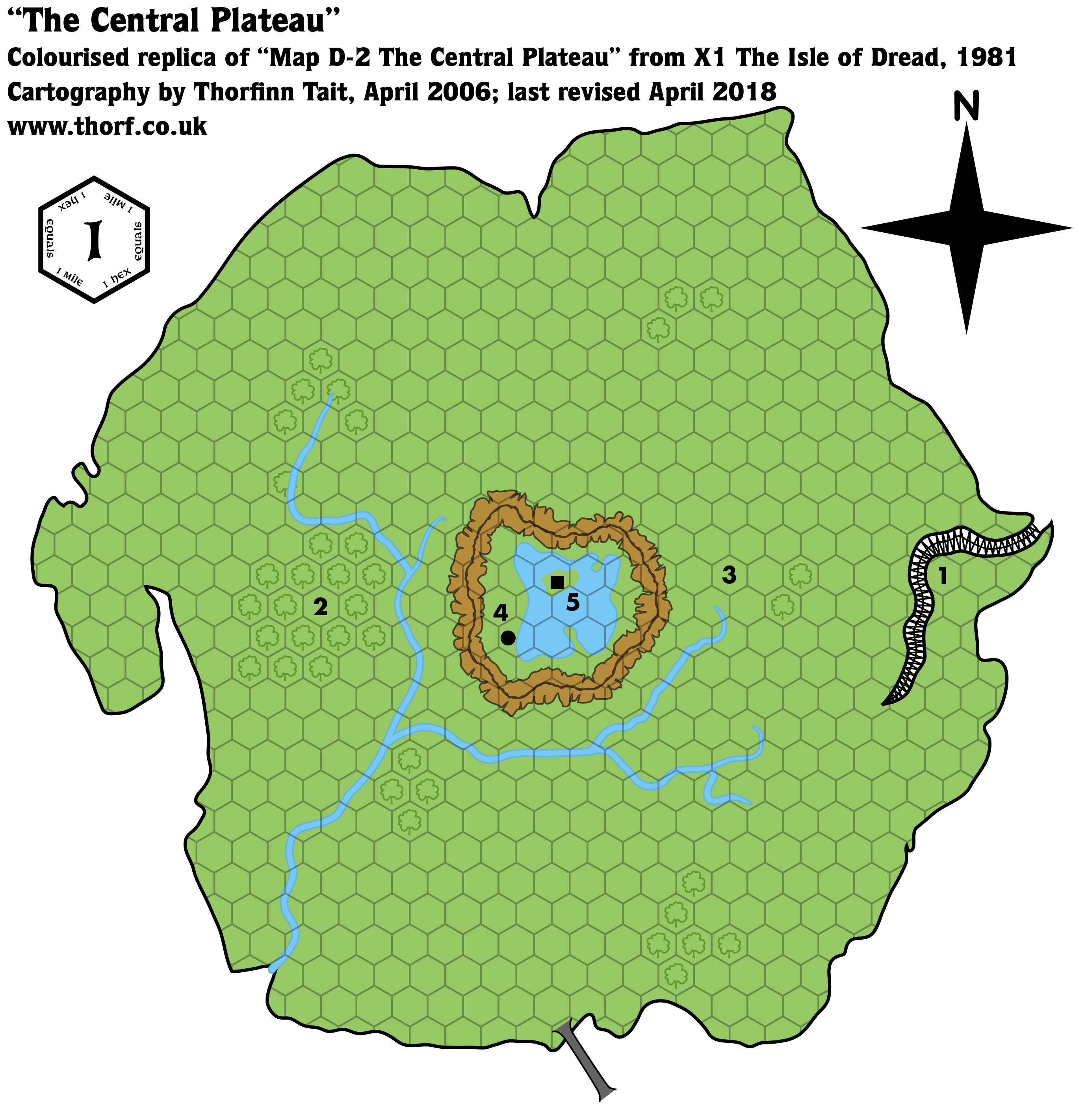
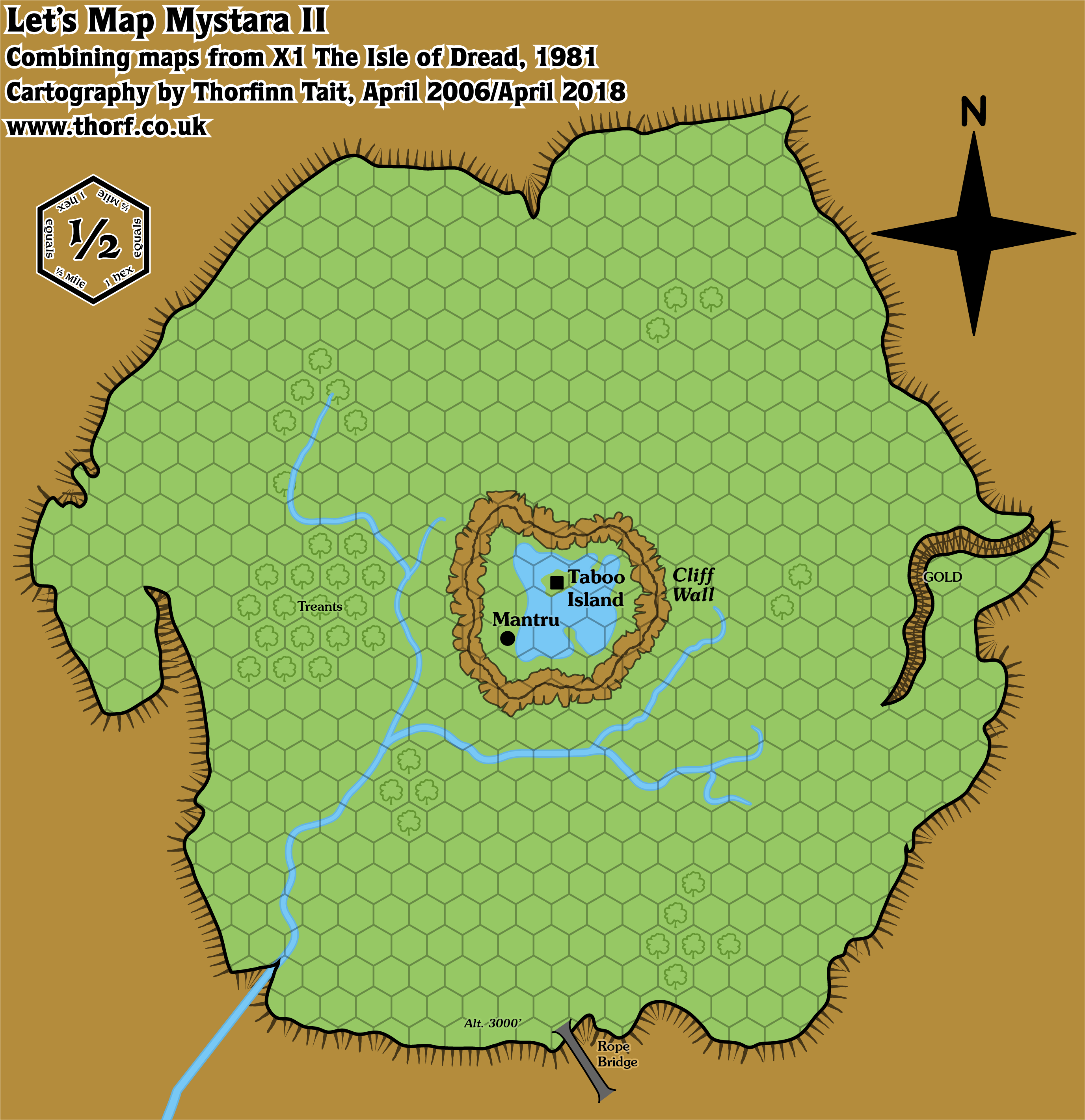
Map 3: “The Central Plateau” from X1 (1981)
Additions
- Terrain — all of the terrain on the plateau is new: forests, ridge, ravine, lake and island.
Revisions
- Bridge — the rope bridge is now shown leading up onto the Central Plateau.
- Plateaus — the shape of the Central Plateau is a refined version of the shape on the Isle of Dread map. Note that at the scale of 1 mile per hex it doesn’t exactly match the size of the smaller scale map’s plateau; in fact it turns out to be a little larger. (See Scale below.)
- Rivers — the rivers on the plateau are more detailed, with multiple tributaries; the general shape remains the same as the Isle of Dread map.
- Settlements — the precise locations of two icons has been tweaked, with the village on the shore of the lake, and the ruins on the island.
- Scale — as with the Isle of Dread map, the Central Plateau map’s scale doesn’t match the other maps. Even assuming the 6 mile per hex scale to be correct, 1 mile per hex for this map makes the plateau turn out to be larger. On the other hand, going with the revised 4 mile per hex scale, the plateau fits rather well with a scale of 0.5 mile per hex.
Hex Art & Fonts
- Fonts — Souvenir for titling and legend; Futura for keyed numbers.
- New Symbols — Rope Bridge, Ridge, Ravine.
Textual Additions (X1 1981)
- Settlements — the village is named Mantru, population 50. The chief is named Fano. (p. 22) The ruins are on Taboo Island, and have a total population of 63 villagers. (p. 23)
- Terrain — the ridge is referred to as the cliff wall. (p. 22)
Conclusions
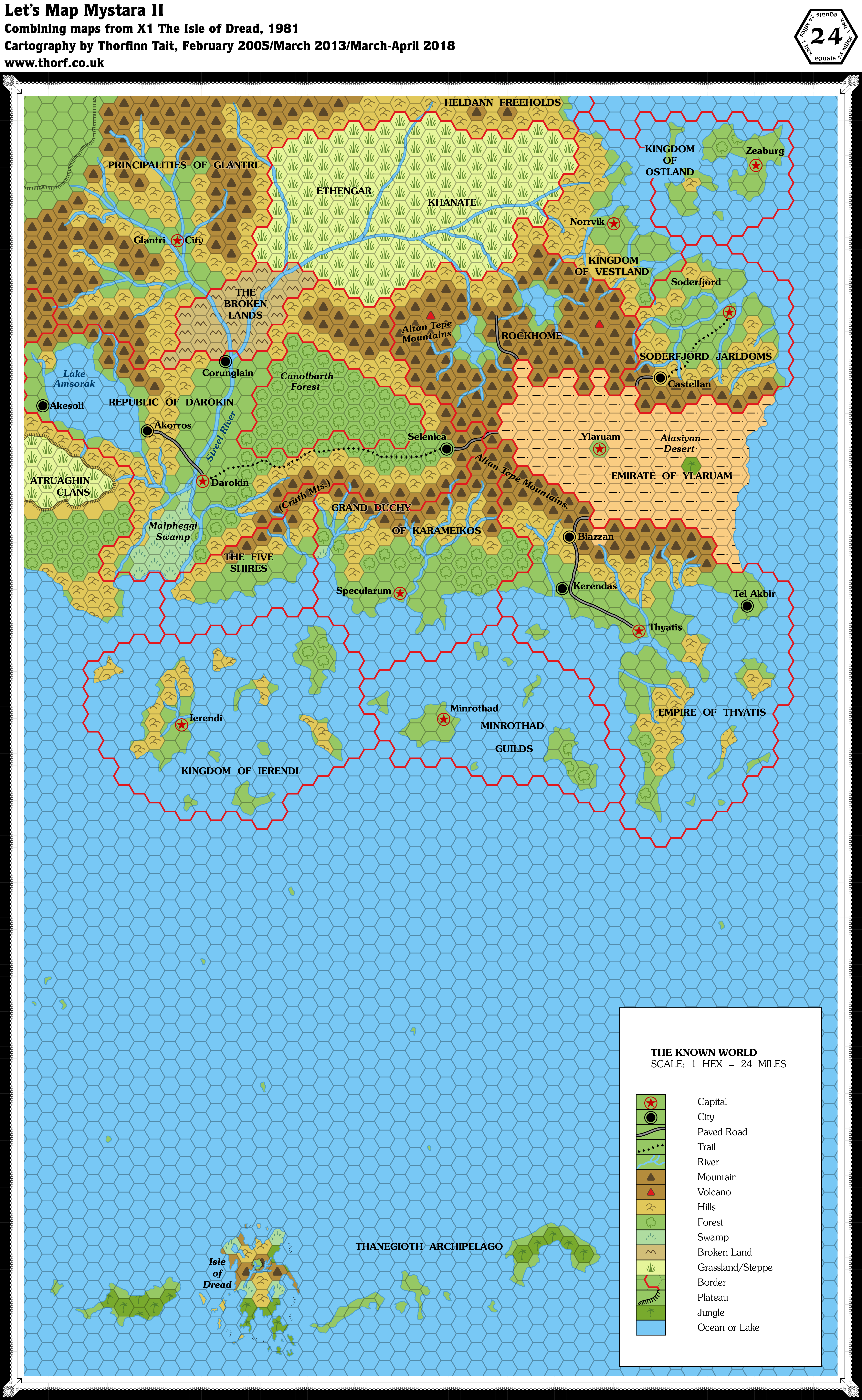
The scale issues are a surprise for maps within the same product. Going forward, I am adopting 4 miles per hex for the Isle of Dread map, and 0.5 miles per hex for the Central Plateau map, as noted.
With these decisions made, it becomes possible to update the smaller scale maps using the larger scale maps, as well as adding features that were missed out in the conversion to larger scale.
Revisions (24 miles per hex)
- Coastlines — the Isle of Dread and surrounding islands have been added.
- Plateaus — an approximation of the Central Plateau has been added.
- Terrain — revised to match larger scale maps.
Revisions (4 miles per hex)
- Bridge — the rope bridge leading up onto the Central Plateau has been changed to the larger scale map’s version.
- Islands — the missing island from the smaller scale map (in the west) has been added in, with hilly terrain to match adjacent islands.
- Plateaus — the Central Plateau has been revised to match the larger scale map.
- Rivers — the rivers of the Central Plateau have been replaced with the larger scale map’s rivers.
Click here to see the updated web map. (It was originally embedded in this post, but that seems to have broken for some reason.)
These experiments with the web map take quite a long time, and I’ve had zero feedback so far. Chances are high at this point that I will make them an occasional thing, once there’s a bit more to show off.
To finish off, here are the three base maps I used to make the web map, showing a compiled set of maps from X1.
Next time: we finish up 1981 with the original Expert Rulebook and a trip to Old Averoigne.


16 April 2018 @ 2:29 am
the web map is neat, but i know how much work it can be from personal experience. I think the web map should really be a separate project with its own goals/parameters; this series is a good way of going through all the data that might be included on the webmap and should be its own thing.
16 April 2018 @ 5:44 am
Hi. lovely to see these old maps. the updates Isle of Dread reminds me of how much i have enjoyed running this adventure over the years. might make it back to the table!
watching this project unfold with interest.
19 April 2019 @ 3:35 am
Forgot to mention; this is why I looked up Thorfinn’s site after many years of Mystara absence. I recently bought the 5E update hardcover of the Isle of Dread and wanted to print a table-sized player map (the rest of my gaming group started with Pathfinder and have no experience with IoDread). And who else would have an svg or at least a crazy high resolution png version?
X1 (1981) Isle of Dread, 6 miles per hex | Atlas of Mystara
2 November 2018 @ 10:37 pm
[…] The following lists are drawn from the Let’s Map Mystara project. For the full context of this map in Mystara’s publication history, including any textual additions that may be made with reference to the associated book, see Let’s Map Mystara 1981, Part II. […]
X1 (1981) Central Plateau, 1 mile per hex | Atlas of Mystara
2 November 2018 @ 11:09 pm
[…] This is Map 3. It was published in 1981. The updated version of this map has not yet been released. See also Appendix C for annual chronological snapshots of the area. For the full context of this map in Mystara’s publication history, see Let’s Map Mystara 1981, Part II. […]
17 April 2019 @ 6:29 am
The web map is interesting, mostly for the zoom since my browser doesn’t zoom generic images and it’s a hassle to open a separate image viewer. The political information is potentially useful, but the boundaries seem fiddly, not unlike 90’s era image maps for cgi buttons. All said, I’m impressed you’re still at it, and doing amazing work!
17 April 2019 @ 9:52 am
Thank you very much for the feedback! These web maps were a bit of an experiment. For now I’ve decided to hold off on them and perhaps do a finished web map at the end of the project to present the final findings. The borders being a bit finicky is probably because they are not very thick, so they can be a bit tricky to find.
It has taken rather a long time, but 1985’s article is almost done, and should be appearing soon. Although I do take breaks from these projects from time to time, I always come back.
Central Plateau, 0.5 mph (1981) | Atlas of Mystara
18 May 2021 @ 9:03 pm
[…] Let’s Map Mystara 1981 II — the original project thread for this map […]
Isle of Dread, 4 miles per hex (1981) | Atlas of Mystara
19 May 2021 @ 8:46 pm
[…] Let’s Map Mystara 1981 II — the original project thread for this map […]