
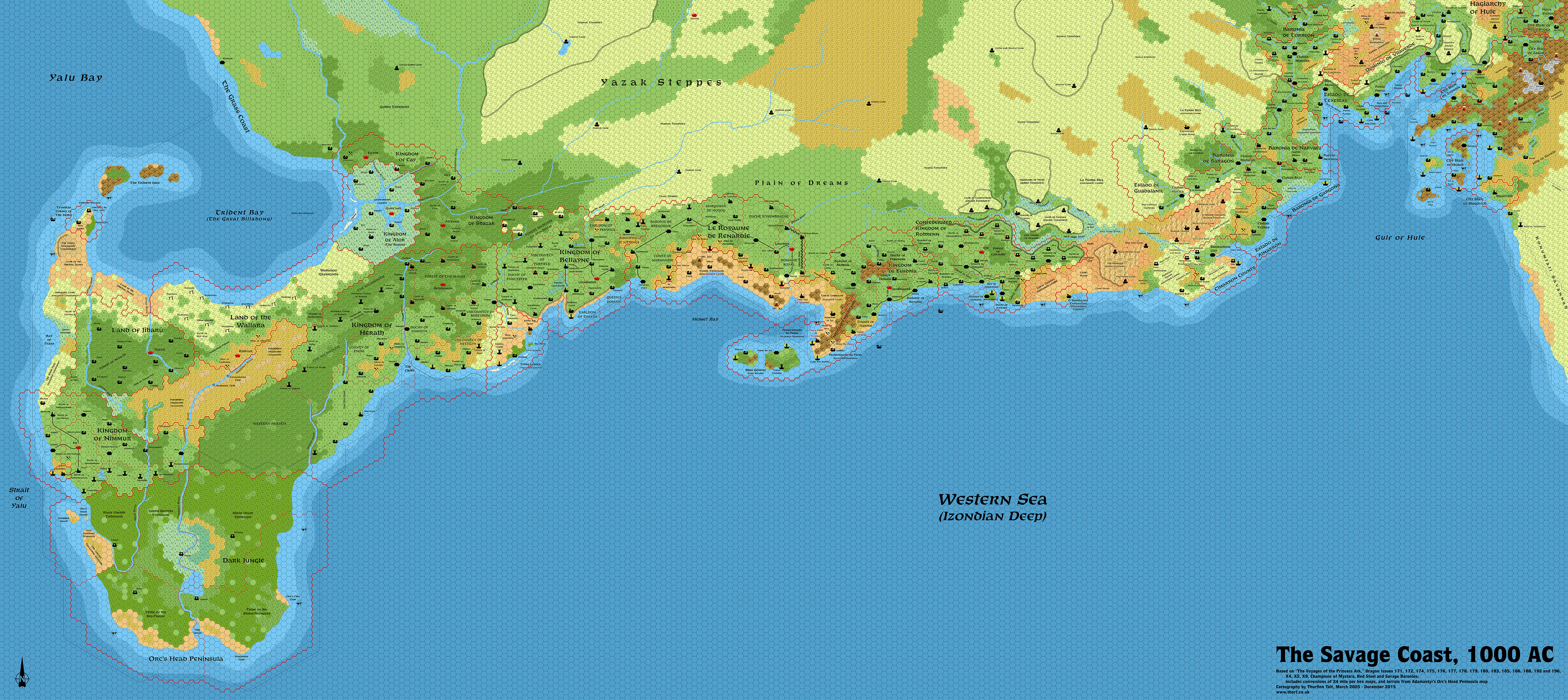
Savage Coast Trail Map
Announcing a new Trail Map for the World of Mystara!
Here it is at last: from the Gulf of Hule in the east to Trident Bay and the Orc’s Head Peninsula in the west, the whole Savage Coast in a single massive 8 mile per hex trail map. It covers the whole area presented in Dragon magazine’s Voyage of the Princess Ark maps, as well as their second edition in Red Steel, with the exception of the Arm of the Immortals. (That will follow soon enough, but I first need to pin down its exact location in relation to the Savage Coast.)
The file you’re seeing here is just a preview — the full resolution file is 19,000 x 8,500 pixels, and you can download it from this direct link.


Lining Up Mystara I – Thorfinn Tait Cartography
13 February 2016 @ 11:28 pm
[…] Orc’s Head Peninsula (Mystara Mapping Issues, Orc’s Head Peninsula and Trident Bay, Savage Coast Trail Map) […]
14 August 2018 @ 4:17 pm
Excellent work on this, Thorf! Just east of Robrenn, there’s a label that says “Badi” or “Badl.” Is that right? Or maybe a “Badlands” label that got cut off somehow?
Adamantyr’s Jibarú and Nimmur, 8 mi/hex | Atlas of Mystara
12 February 2021 @ 9:01 pm
[…] map. It was published in 2000. The updated Atlas version of this map is currently available at Thorfinn Tait Cartography. See also Appendix C for annual chronological snapshots of the area. For the full context of […]
Adamantyr’s Reptile Kingdoms, 8 miles/hex | Atlas of Mystara
15 February 2021 @ 11:34 am
[…] map. It was published in 2001. The updated Atlas version of this map is currently available at Thorfinn Tait Cartography. See also Appendix C for annual chronological snapshots of the area. For the full context of […]
Adamantyr’s Savage Coast, 8 miles per hex | Atlas of Mystara
8 May 2021 @ 5:48 pm
[…] map. It was published in 2020. The updated Atlas version of this map is currently available at Thorfinn Tait Cartography See also Appendix C for annual chronological snapshots of the area. For the full […]
Adamantyr’s Trident Bay & Orc’s Head | Atlas of Mystara
1 July 2021 @ 9:33 pm
[…] map. It was published in 2015. The updated Atlas version of this map is currently available at Thorfinn Tait Cartography. See also Appendix C for annual chronological snapshots of the area. For the full […]
Thibault’s Savage Coast, 8 miles / hex | Atlas of Mystara
19 July 2024 @ 9:58 am
[…] map. It was published in 2021. The updated Atlas version of this map is currently available at Thorfinn Tait Cartography. See also Appendix C for annual chronological snapshots of the area. For the full context of […]