
Mystara Climate Maps
Creating 72 mile per hex maps for Mystara’s continents has led me to investigate Mystara’s climate. I’m going to sum up the issues here before reporting on my progress.
Bruce Heard posted two articles about Mystara’s climate on his blog back in 2012: Climate in Alphatia and The Winds of Brun. In these articles, he outlined a climate system for Mystara based on the Köppen climate classification system (see also climate at Wikipedia). Most usefully, he marked the climates, ocean currents and predominant winds on Michele Carpita’s existing Mystara Climate map (which showed Brun and the Alphatian Sea area, as well as the northern tip of Davania and western Skothar).
I started a thread over at The Piazza, to explore finishing off Bruce’s work, and some great ideas were posted by Robin and others, which should be very helpful in filling in the missing parts of Davania and Skothar.
In the meantime, I decided to move ahead with assembling the coastlines resulting from my Lining Up Mystara project. This is obviously an essential step in making the hex maps, but also in constructing a new world map — something that has been a mere dream up until now.
I tackled each continent separately, starting with Skothar (the easiest) and finishing up in Brun (by far the most complex). Luckily I already had all of the source maps in vector form, so the main task was copying, pasting, rescaling, and then merging them all together. To sum up:
- Skothar: I took my traced Master Set coastline and the best of the 72 mile per hex coastlines — which turned out to be Dawn of the Emperors in most cases. The hex mapped areas overrule the Master Set world map, so I deleted that part and then merged these all together. The only exception is Minaea’s little inlet bay, which was not on the hex maps but I decided to preserve anyway — a very rare example of disregarding the hex maps in favour of another map. With Skothar itself done, I brought in the outlines from my 24 mile per hex maps of Alphatia, the Alatians, Ochalea, and the Pearl Islands. Finally, I added CM1’s Brun map to get Orol Island and its southerly neighbours.
- Davania: The main base is again the Master Set coastline, but I decided to add Princess Ark maps from Dragon 155, 157 and 158 to get more detailed coastlines for those parts, which is to say the eastern Jungle Coast down to Fire Bay, including Cestia, Oceania, Everfeed, as well as the Vulture Peninsula. Next I added Poor Wizard Almanac II‘s 72 mile per hex map, and incorporated Champions of Mystara‘s 24 mile per hex fragment from the Serpent Peninsula map. Finally I brought in the results of my Skothar map, including CM1’s Brun map, and added the two extra Pearl Islands.
- Brun: This one took a long time. Starting with the 8 mile per hex maps, I brought in the Known World and Sind coastlines, then the Savage Coast and Trident Bay area’s. Next came the 24 mile per hex coastlines, with the Great Waste, the Isle of Dawn, my Arms of the Immortals map, and CM1/M2’s Norwold. I’m glad I already had this stuff partially collected together, or it would have taken even longer. After slotting all of this in, I then brought in CM1’s Brun map, and cut it up to allow two placements: one for the Arm of the Immortals/Orc’s Head Peninsula area, and another for the rest of the map. In the end, this map fits rather well with the results of my project, with the stretch from the Arm to the Gulf of Hule being the sole exception. I ended up basing Yalu Bay largely on CM1 and Savage Baronies, with an eye to maintaining compatibility with the main new parts of Dungeon 6’s Great Northway Lands map.
As you can imagine, this took about a week to do. But now that it’s done, I can finally produce new world maps for Mystara.
So let’s take a look at my progress with this. First up, with the finished coastlines I decided it would be fitting to produce a new Robinson projection map. This one is far from finished, but I want to share my work-in-progress version with you so you can see what it’s going to be like.
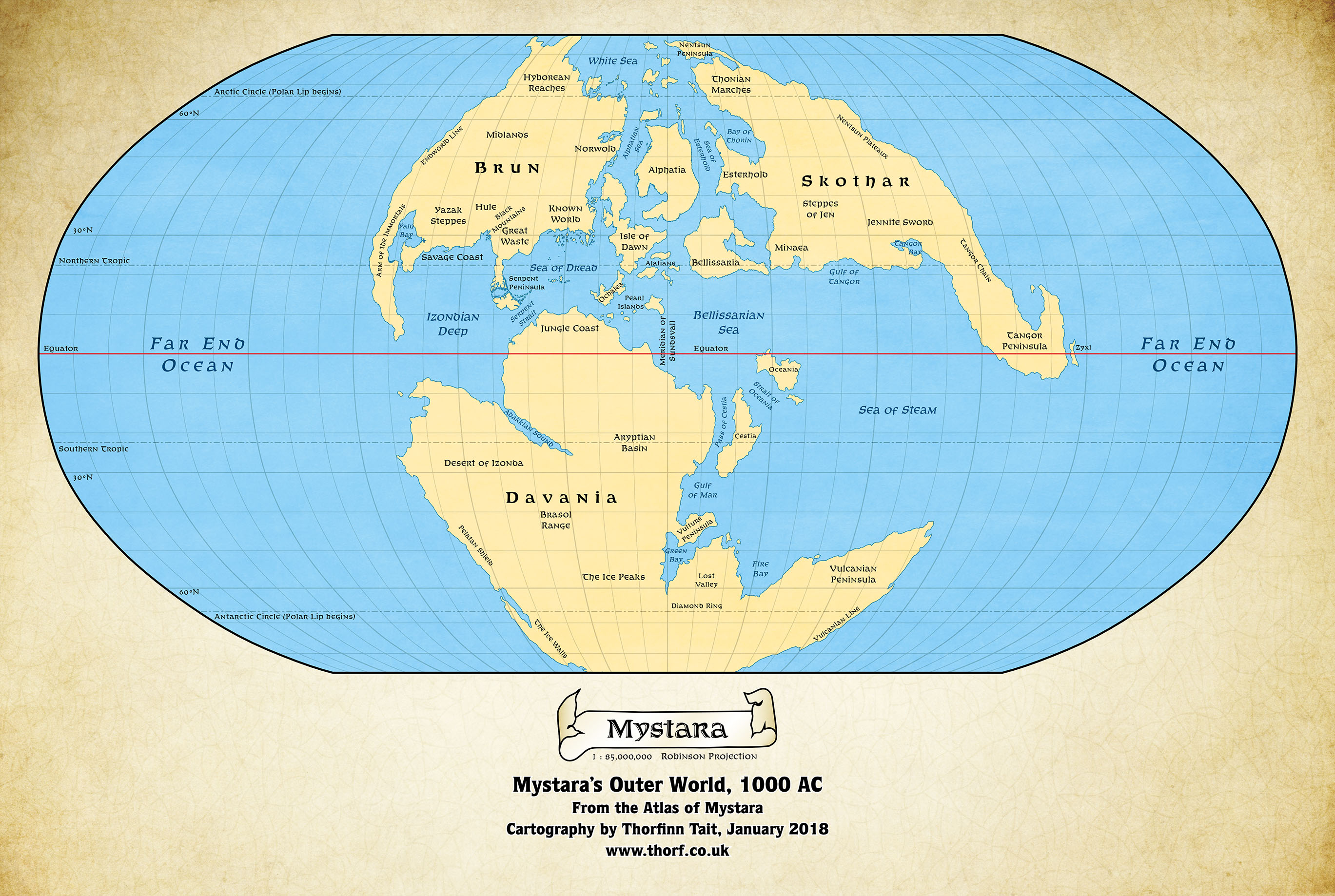
What I’ve done here is take the Equirectangular projection coastlines that resulted from my Lining Up project and reprojected them into a Robinson projection. Note the lack of stretching compared the Hollow World Set‘s map.
It’s worth remembering that the extreme north and south of the map are extremely non-standard (to say the least), and in the finished map I intend to show absolute north as well as the beginning of the polar lip. The Polar Openings themselves will require their own maps, but that’s a topic for another day.
Next up is the current goal of all this work: the in-progress climate map.
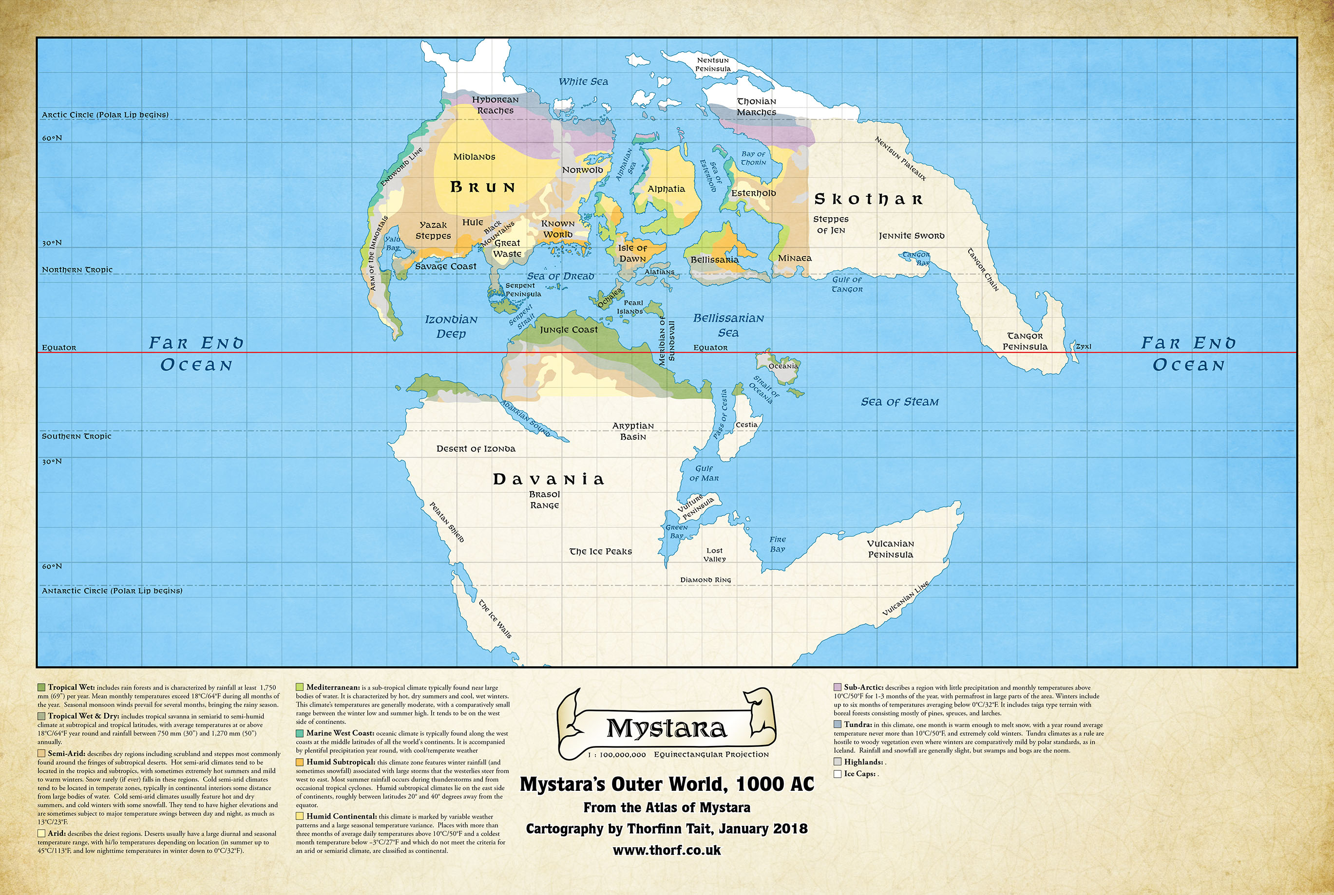
What I’ve done here is adapt Bruce’s climate map to my Equirectangular projection’s coastlines. It took a bit of tweaking, and it’s not exactly ideal in that it would work much better with some of the terrain (mountains, rivers, lakes, plateaus) in place. That’s coming next, along with filling in the blank areas of Skothar and Davania.
Once the climate map is complete, I’ll get back to hexing the continents.