Let’s Map Mystara 1983
In which we move through the world’s first mega expansion: 1983. Stay with me, it’s going to be a long post!
Mystara Geographic Maps 1981-1983
I’m afraid I still haven’t tackled B3 yet, but it’ll have to wait for another post.

In which we move through the world’s first mega expansion: 1983. Stay with me, it’s going to be a long post!
I’m afraid I still haven’t tackled B3 yet, but it’ll have to wait for another post.

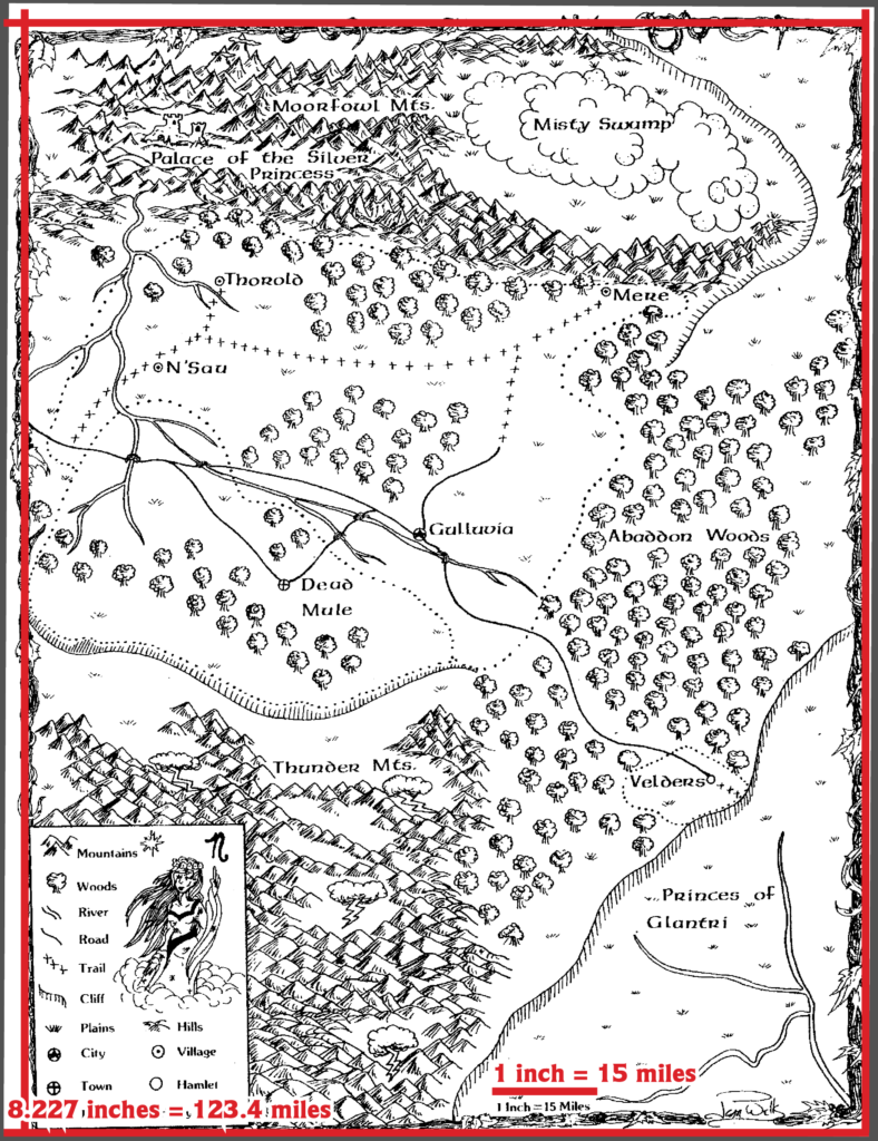
The original version of B3 Palace of the Silver Princess (1981) included a map of Gulluvia, in the region that would later be the Adri Varma Plateau. The module itself was recalled and destroyed — you can read the full story at the Vaults of Pandius here, as well as download a PDF of the original module, which Wizards of the Coast made available more than twenty years after its abortive release.
The Gulluvia map was almost certainly unknown to Mystara’s designers due to its history, and as a result of this no other products reference Gulluvia, and the Adri Varma Plateau was developed in another direction, taking on a wastelands theme with extensive badlands and cacti.
Because of all this, as well as the nature of the map itself, integrating Gulluvia into Mystara is quite a challenge at this point.
Michele Carpita and the Italian Mystara community chose to adapt it to the new conception of the Adri Varma, placing various elements from B3’s map into the terrain from maps in Wrath of the Immortals. I have posted an archive of the original post for reference. Francesco Defferrari has created a larger scale version of Michele’s map, available at the Vaults. Omnibus has written a gazetteer for this version, bringing it and other fan ideas for the Adri Varma into a cohesive whole. Gary Davies produced the English version of this, together with an English version of the map.
But my Let’s Map Mystara project demands that I place it using only contemporary maps if at all possible. So I’d like to explore the map with reference only to the original X1 map.
Before we continue, it’s also worth noting that Entire Party Killed has already created an 8 mile hex replica of B3’s Haven map, but it requires an account to access. This is relevant because if possible I’d like to make my map fit with the placement of their hex grid.
The first challenge is working out the scale. The map itself has a label claiming 1 inch to equal 15 miles. It was likely printed on a standard US Letter-sized page (8.5 inches across), and indeed the scan measures 8.227 inches across, which seems consistent. Taking this at face value, we can work out the exact scale as follows. First, I created a 15 mile ruler, scaled to my georegistered version of the X1 map. Next, I scaled this to 8.227 times its original width, which comes out at 123.4 miles.
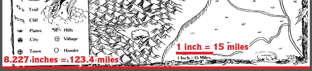
With this measurement done, the exact scale of the map should match X1. Next, I noticed that the map was a little squint on the page, so I rotated it ever so slightly to make the borders look a bit straighter. It doesn’t seem possible to make them completely straight, however, as they were clearly drawn a little squint.

It’s been a while since I’ve written a post for this project, but that’s not from lack of progress or activity — quite the opposite. In fact I’ve been repeatedly amending and revising a post for over a month now. Now it’s finally ready to share.
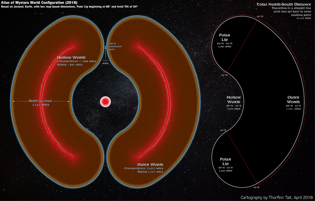
After the last article, I discovered that my calculations were a bit off. I’m not exactly sure why this is. I posted about this in the Facebook Mystara Cartographic Society (embedded below, if it’s working), and after discussions there (check the “Is my maths off in some way?” comment thread for details) decided to go with a round 36,000 miles for the circumference — primarily because chasing an exact 72 miles per hex was not working, and because this figure gives an easy 100 miles per degree.
Unfortunately, this didn’t work out either — it ended up giving far bigger hexes than I had expected, with 24 mile hexes coming out at 26 miles.
So I left it for a month or so. And then it hit me: I can reverse-engineer the circumference from measurements in Illustrator.
Basically, what I did was measure a hex, then divide the circumference by that number. Then I multiplied that by the desired hex size, which gave the actual circumference I needed to define the ellipsoid.
It turns out that Atlas Mystara has a circumference of 33,032 miles, which is quite a bit smaller than previous estimates. But this indeed made the measurements for hexes come out nearly perfectly in Illustrator, so I’m locking this in as our final circumference for the new 2018 model.
Phew! Now I just have to go back and re-georegister all those maps. Thankfully I already know how to do this without losing all the GIS data I’ve been inputting, and it’s not very hard.
As a consequence of all this, I have had to rebuild the model yet again — hopefully for the last time!
Oops… Looks like I spoke too soon…