
Lining Up Mystara XII
Reconciling the World Map II
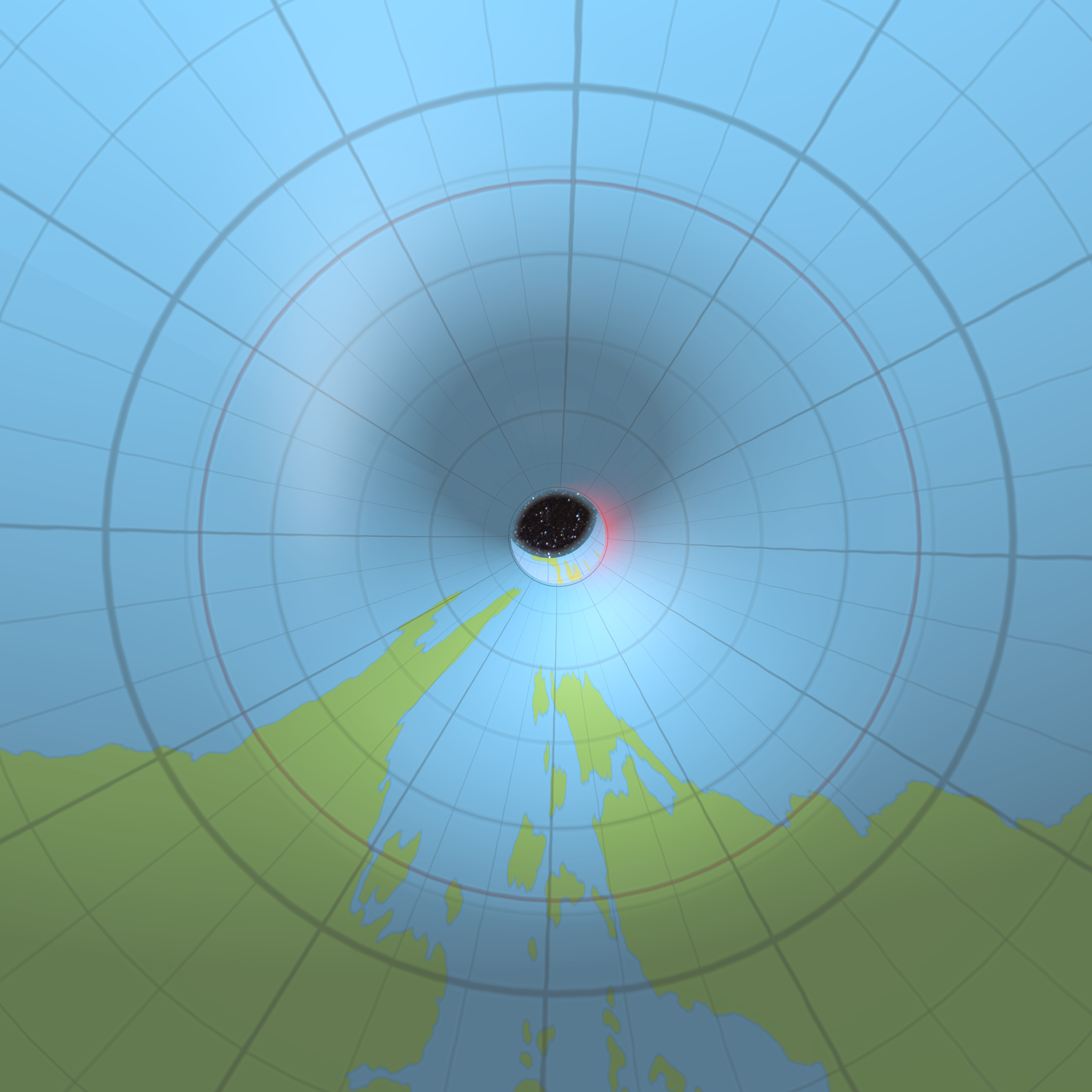
Skothar
Let’s start with Mystara’s eastern continent. We actually have most of the western coast of this in hex maps, but the actual continent is huge, so it’s just the tip of the iceberg.
I already established last time that I’d rather not apply a rotation to Skothar’s Master Set outline if at all possible, in order to maintain its latitudes. I’d also rather keep it the same scale as Brun if at all possible. Let’s see how that works out:
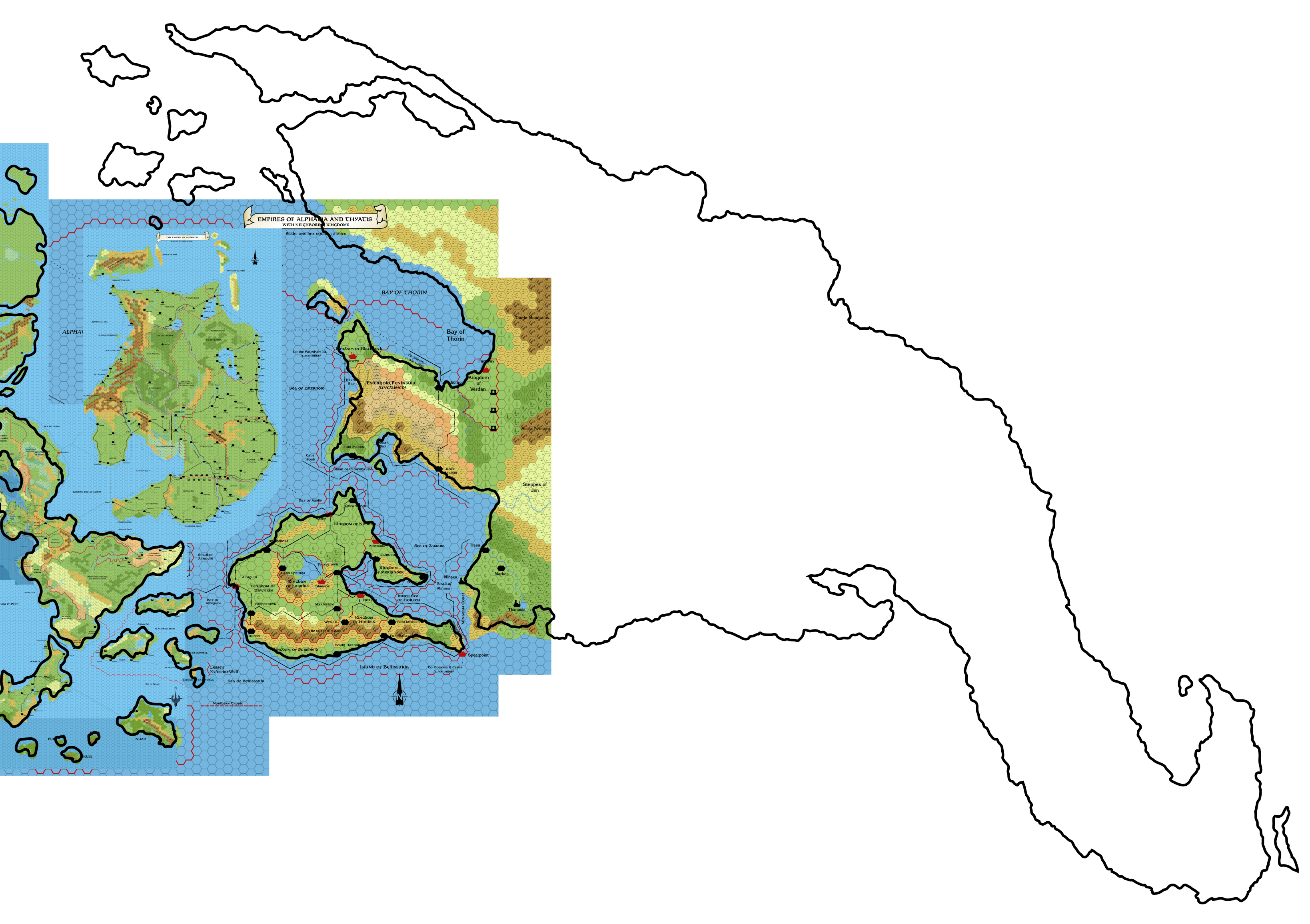
This is not too bad. I based the fit on the Bay of Thorin, lining up the southern coast with the edge of Minaea on the hex maps.
Of course there are numerous problems. First and foremost, the northwestern coast is quite far out from its hex map version. I’m tempted to revise the hex map to go with the world map here, because we haven’t generally been placing a lot of faith in the Dawn of the Emperors 72 mile per hex map. However, the standard up until now has been to go with the hex maps, and this seems to be where community consensus lies every time. So let’s go with the hex coastline and join it to the world map coastline as best we can.
Esterhold is actually the least of our problems, because we have all of it on hex maps. I’m happy with this fit, even it’s a bit loose, because it’s only acting as a placement guide.
Minaea is more problematic, because the coastline is very different. At first I thought perhaps the map needed rescaling, because doing so would surely make the northwestern coastline line up, too. But this would require Skothar to be scaled significantly larger than Brun, which seems rather undesirable. It seems better to preserve the relative sizes of the continents, after all.
Look more closely at the small bay on the world map outline that’s entirely missing from Minaea’s hex map. The coastline after that bay seems to line up pretty well with where the hex maps were going. This leads us to another decision between hex map and world map: do we incorporate this small bay into Minaea’s hex maps, or just ignore it?
Actually, I think we could do both, simply by shifting the bay two hexes to the east. That would allow us to keep the detail while preserving the authenticity of the printed hex map.
Finally, I’m quite happy with the placement of the isles north of Alphatia. This is perhaps the most arbitrary thing about this placement, but I’d rather have them placed relative to Skothar, with no rotation applied, than lump them in with Brun. The distance between the islands and Brun, and indeed Alphatia, seems fine. It should be noted that the hex maps require a placement of Skothar that’s further south than the world map has it, so these islands have also moved south. It seems to make sense to keep them in line with Skothar and especially with the Nentsun Peninsula.
So to conclude, I think this is the best fit we can get for Skothar. We keep it the same scaling as Brun, but without any rotation, and join the world map outlines to the hex maps as best we can.
That just leaves…
Davania
Up until now we’ve been working with areas with the hex maps locked in already, so it has been relatively easy to work out placements.
Unfortunately, Davania’s hex maps are not compatible in this way. In fact, all three of Davania’s appearances on hex maps conflict with each other. Let’s take a look:
(If you can’t see this, the maps are available here and here.)
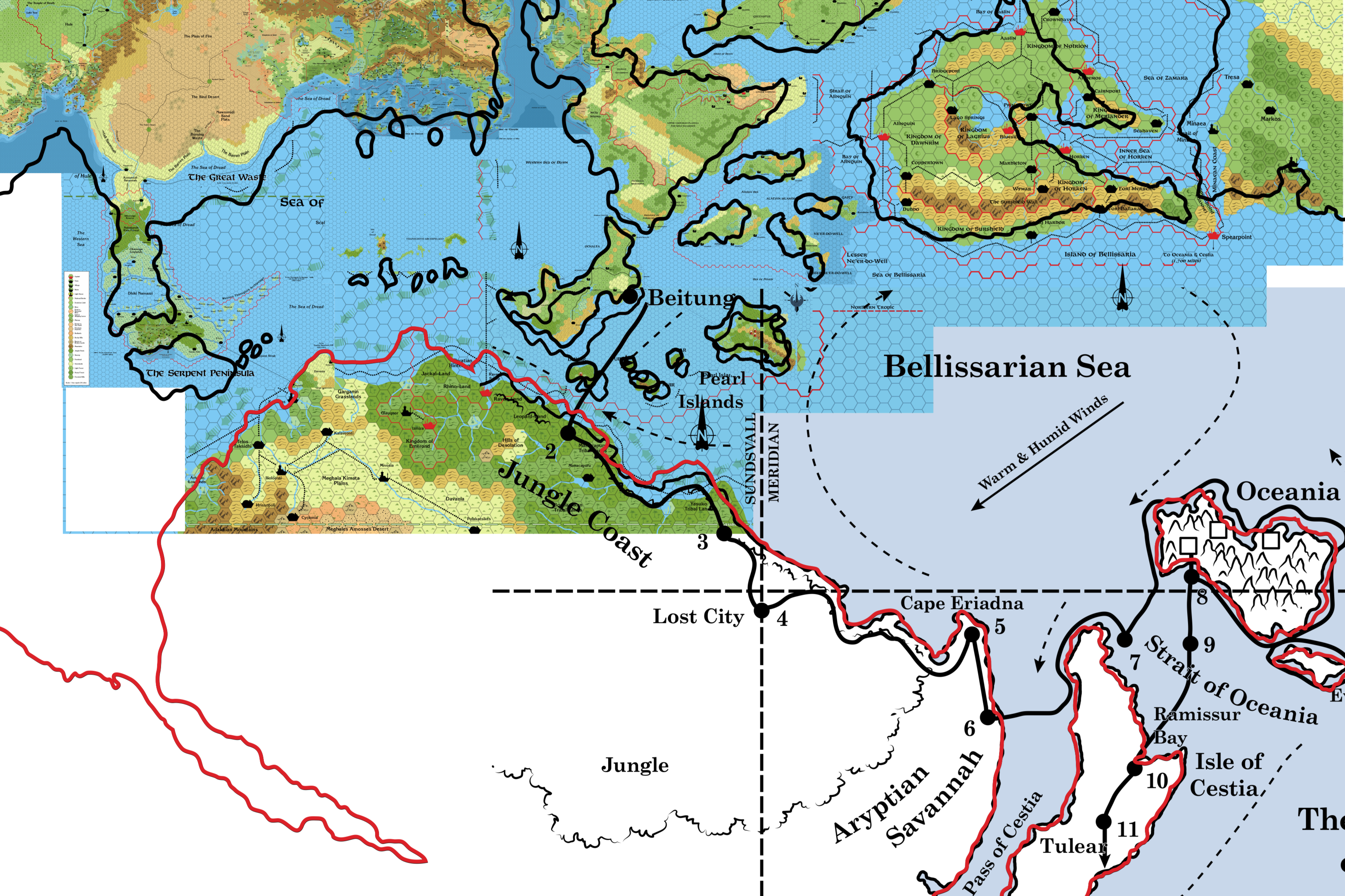
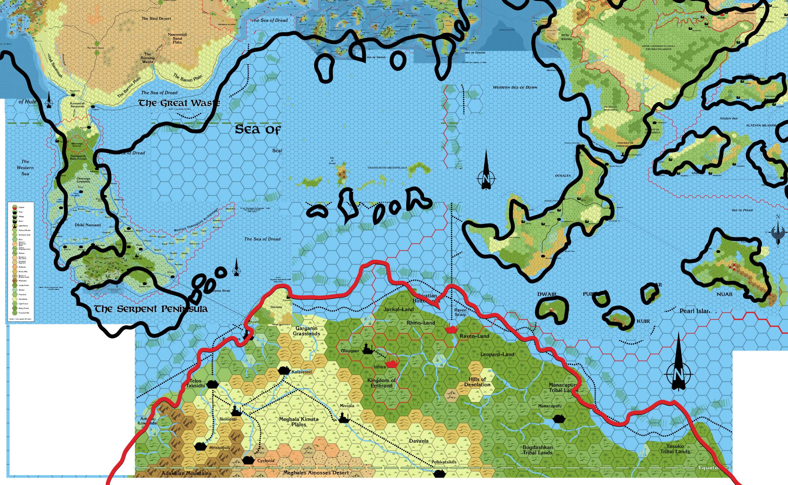
This comparison shows our base hex maps with the three sources for Davania: Champions of Mystara‘s 24 mile per hex map (the corner of Davania is visible on the Serpent Peninsula map); Dawn of the Emperors‘ 72 mile per hex map (showing the Thyatian Hinterlands); and Poor Wizard’s Almanac II‘s poster map (showing the largest chunk of Davania on any hex map). Since Champions and Dawn‘s maps only barely overlap each other, I put them together.
Note first how both Kastelios and Garganin are one hex to the north in Champions compared with PWA2. The coast itself is about a hex and a half to the north. This location discrepancy aside, these two maps give similar views of this small area. The most important point is that Champions places Davania closer to the Serpent Peninsula.
On the other hand, Dawn‘s map and PWA2 are completely at odds with each other. The really big difference is in the shape of the land itself, and the position of the Thyatian Hinterlands. They both place Davania’s northern tip at roughly the same latitude.
To sum up the problem:
- Sources conflict on Davania’s exact position
- They also disagree on the shape of the coastline
What to do?
Latitudes and the Equator
My preference is to take a side-route at this point and deal with the issue of latitudes and the equator. Why? Because the position of Davania is inextricably tied up with the position of the equator — which in turn largely dictates where the rest of the latitudes fall.
The equator’s location is another area where official maps disagree. Michele Carpita produced this map which shows the situation quite nicely:
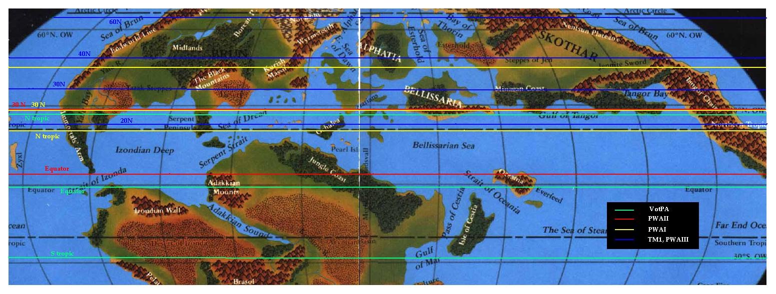
This is the Hollow World Set Outer World map. It’s a very problematic map, as I have already stated, but its latitudes are not necessarily affected by this, so let’s take a look.
The equator on this map is almost the same as that given in The Voyage of the Princess Ark (marked VotPA on this map, in light green). It brushes the northern tip of Izonda, bisects the Adakkian Mounts and the Jungle Coast, passes just north of the Cape Eriadna next to the Pass of Cestia, north of Cestia itself, then under the “hook” of Oceania. Not visible on this map is that it brushes the southernmost tip of Skothar in the far east. I remade the relevant Princess Ark map for reference.
The red line shows PWA2’s equator, which is further north. This one is problematic, and I much prefer the Princess Ark maps as a source for this.
The rest of the latitudes are not quite so important, except that official sources place Thanegioth (presumably the Isle of Dread) at 20ºN, Thyatis at 30ºN, Landfall at 40ºN, and Farend is 60ºN. (These are from TM1’s “Sunrise and Sunset” table, and were repeated in Poor Wizard’s Almanac II.) These are marked on Michele’s map above in blue. Note how the Hollow World Set‘s map has a totally different set of latitudes.
I contacted Bruce Heard about these issues, and he replied that his calculations may have been wonky, and may need updating.
My conclusion is that we should use these numbers as guides, and see how things go. I highly doubt it will be possible to make all of them work, but we can use the most important of them — Thyatis being at 30ºN — together with the equator location to scale the rest of the latitudes properly.
Note also that the locations of the tropics is not relevant, because these are determined by the axial tilt — which we have already arbitrarily set at 24º. Thus, the tropics will appear at 24ºN and 24ºS. These were not consistently placed in official maps, so I am disregarding them.
Davania and the Equator
First, let’s overlay Davania’s Master Set outline with Dragon 155’s map showing the location of the equator. I’ve added in Dragon 158’s map for good measure.
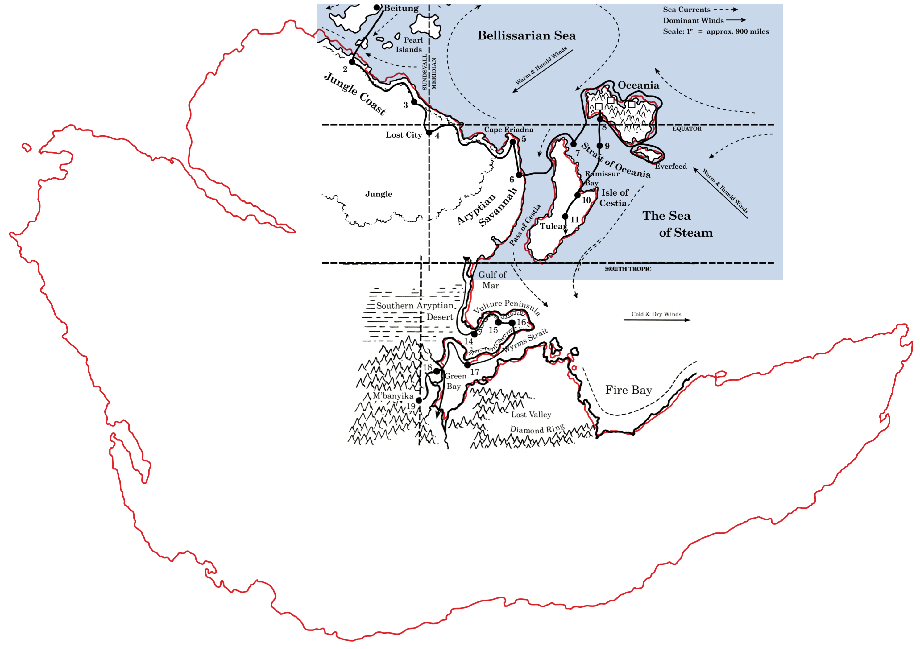
I went for a best fit with these rather than lining up the meridians. So far so good. They fit pretty well. The northern tip of Davania seems slightly out of sync, though.
The question is, how does this relate to the rest of the world?
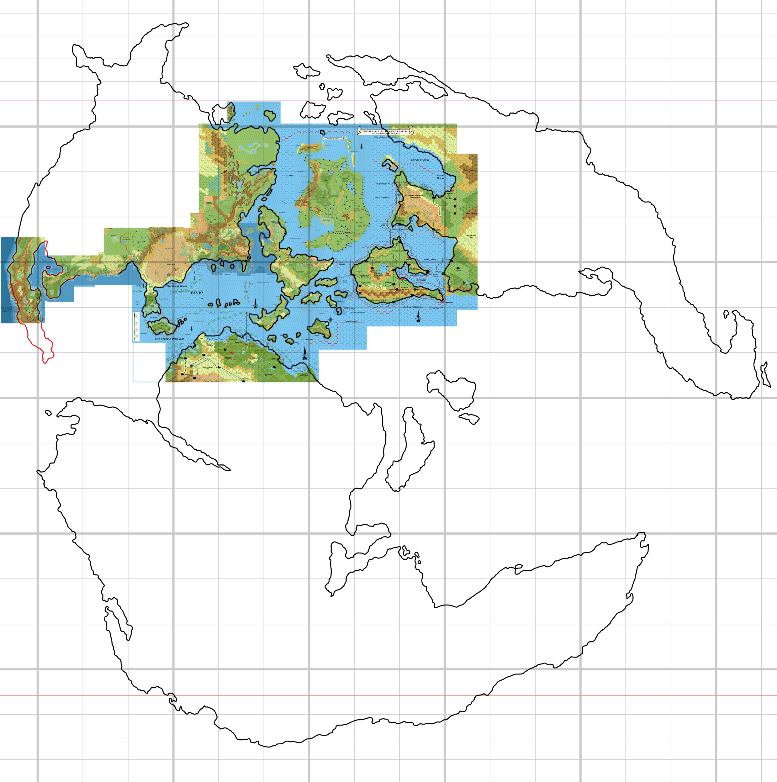
Well, it depends on what we use as a reference point. The Master Set map itself is out of the question, as we’ve already seen that it had to be cut up and spread out in order to match the hex maps. But let’s slot this in anyway just to see how it looks:
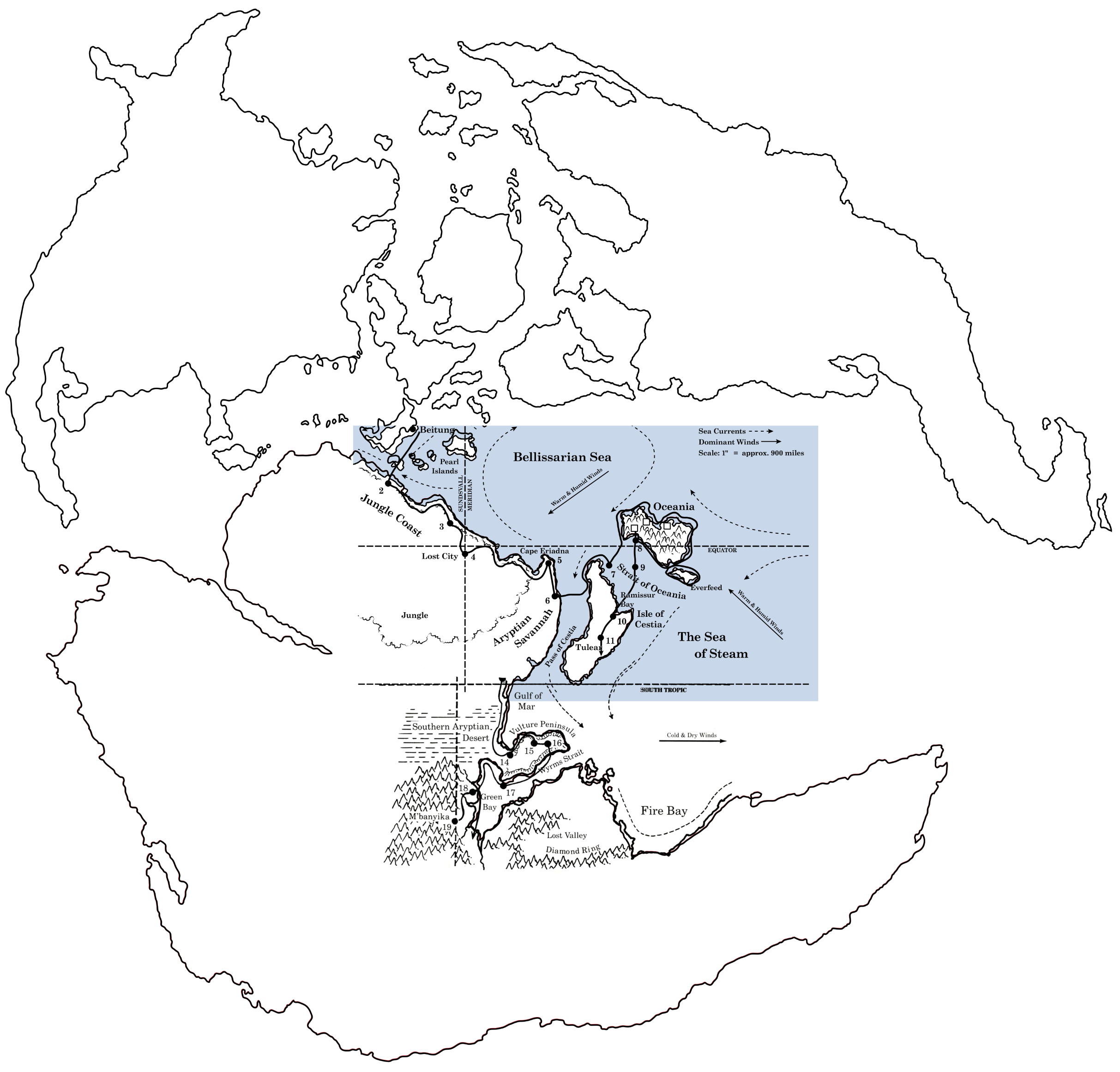
It could be better… Ochalea and the Pearl Islands already being out of sync bodes ill for how this will look with the hex maps. The problem is, what do we line it up with?
Let’s explore some possible placements:
Placement 1
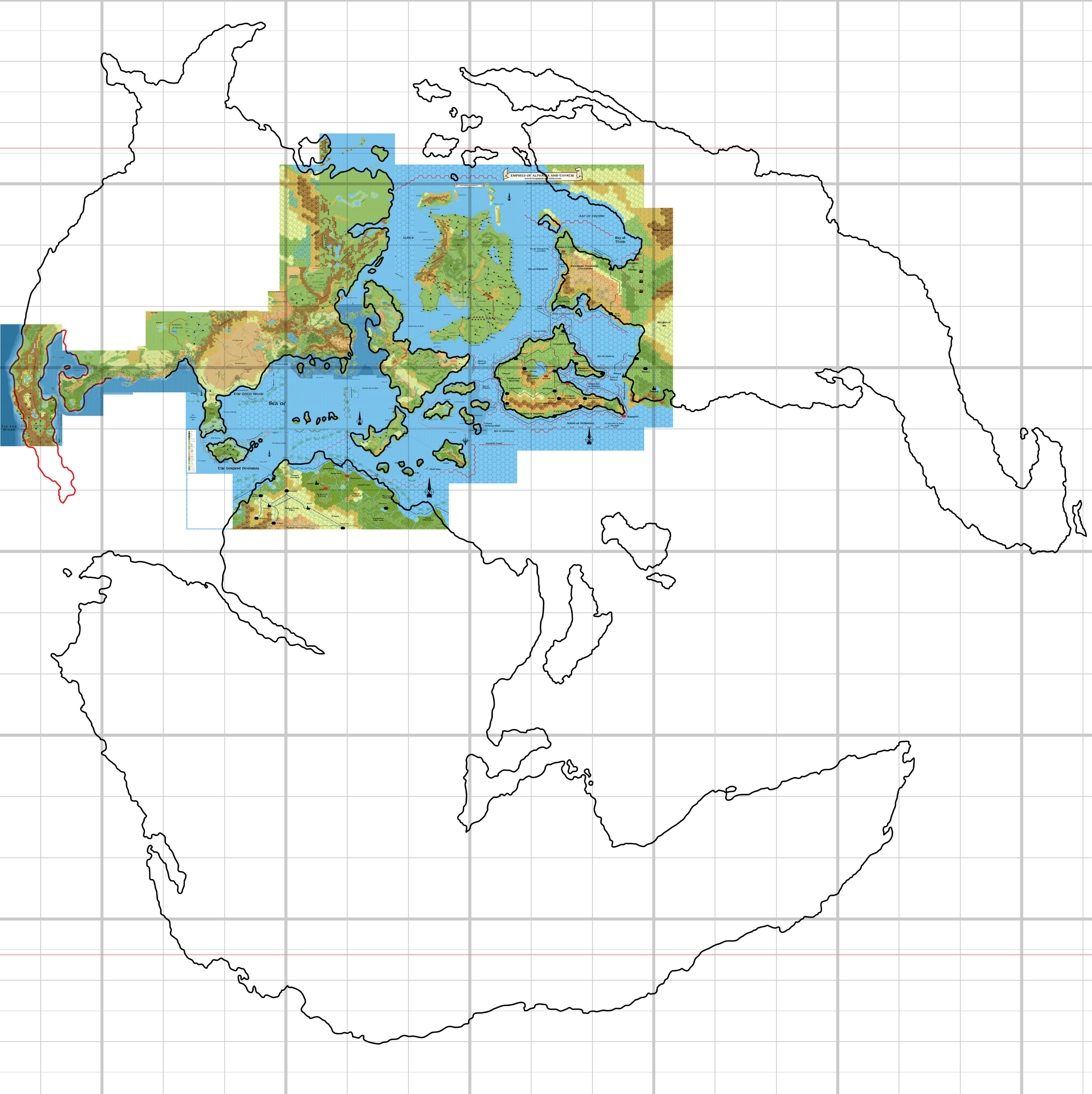
Placement 1 is based on Champions of Mystara‘s Serpent Peninsula map, lining up Davania’s outline with the small area showing Kastelios and Garganin. The black outlines over the northern continents and landmasses are the Master Set map’s coasts, in their placement
- Pro — the 24 mile per hex map is the largest scale to show Davania on any map, and could therefore be considered to be the most accurate.
- Pro — the Master Set outlines of Ochalea and Dwair match hex map Ochalea and Dwair almost perfectly. This means that the relative locations of Ochalea, the closest of the Pearl Islands, and Davania match the Master Set world map.
- Con — the Serpent Peninsula is in a totally different position relative to Davania from where it fits on the Master Set map. However, Champions‘ map could be considered to supersede this anyway.
- Con — with the equator in this location and Thyatis at 30ºN, the extreme northern and southern areas of the world are devoid of land, meaning that there may be more space between landmasses within the polar openings.
This placement could be made to work if we revise latitudes so that Thyatis is a bit north of 30ºN.
Placement 2
This is just placement 1 with latitudes redefined so that the landmasses stretch almost to the limits of the world. This should result in a placement similar to the one I modelled back in Lining Up Mystara X.
Specifically, the north polar opening should look something like this:
- Pro — the polar openings would look more like they do on official maps, with roughly the same amount of landmasses folding into the poles.
- Con — Thyatis would be at around 32ºN, and none of the other official latitudes would be quite correct. They would be reasonably close, though.
Other Placements
Other possible placements include lining up Davania with PWA2 or Dawn of the Emperors‘ maps; rethinking the equator and going with PWA2’s location for it; or trying to keep the relative placement between the Thanegioth Peninsula and Davania from the Master Set map (this last would involve Davania bumping into Dwair, unfortunately).
There’s an interesting effect when moving Davania: moving it south moves the equator south, resulting in Brun and Skothar moving north and being shrunk slightly. Moving it north moves Brun and Skothar closer to the equator, and enlarges them slightly. For the same reason, the Princess Ark equator makes Davania slightly bigger, as it straddles the equator more, while the PWA2 equator leaves it slightly smaller — and Brun and Skothar slightly larger.
Conclusions
This isn’t something I can just decide by myself, so I’d love to hear some feedback before continuing. Having said that, I also want to continue with this ASAP, as my mid-February deadline is upon us, and I need to get this done and move on to my next project.