
Jurassic Earth as Mystara
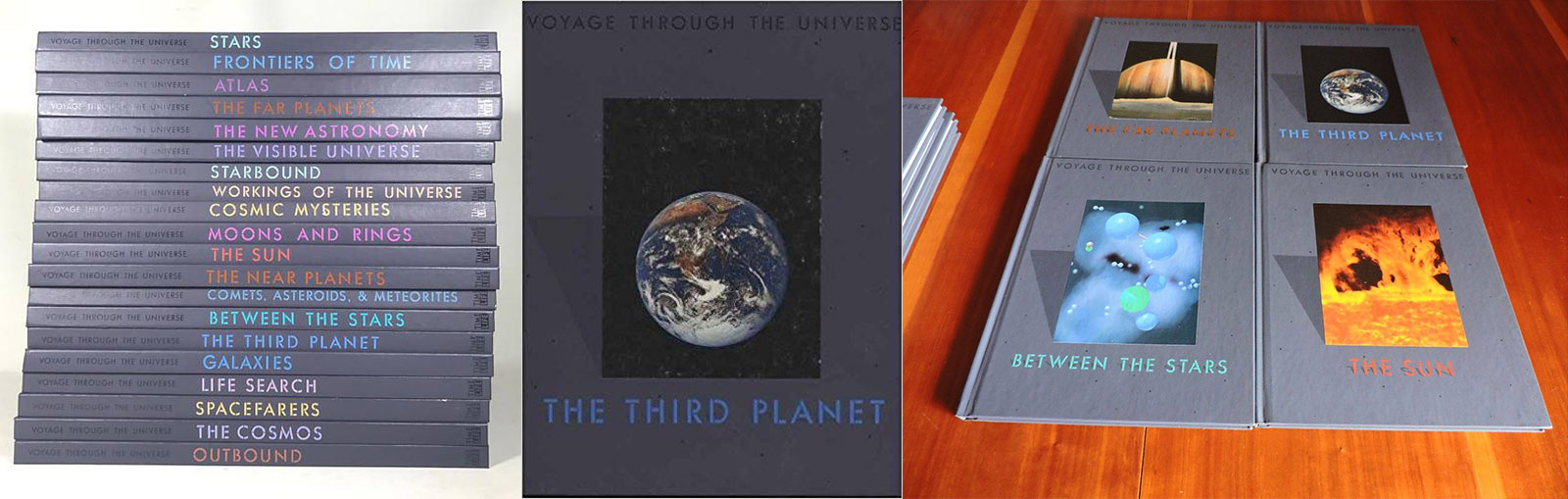
About thirty years ago, my father bought two wonderful sets of books about the Earth. Along with our world atlases, I adored these books. (There are definite advantages to having your father be a scientist.) I loved to read about the solar system, gemstones, ice ages, earthquakes and volcanoes. But my absolute favourite were those that told about plate tectonics, and showed what the earth used to look like. I took these books aside, and kept them close on my own bookshelf.
Mystara fans will likely know why I was so interested in plate tectonics: one of the maps bore a striking resemblance to our favourite game world — so much so that it was obviously the inspiration behind Mystara’s world map.
Over the years, I tried to find the map online, but without success. Not for any lack of paleogeographic maps of the Earth, but rather because these maps have evolved quickly and drastically over the years, as the scientists who draw them incorporate new data and new techniques. Many maps came close, but none fit as well as the one I remembered.
Fast forward to the present, and I came across a series of articles by Lance Duncan last week, in which he reconstructed Mystara’s world map based on a similar map of ancient Earth (below).
This map is pretty close, but the isobars and rainfall data somewhat obscure the coastlines — it’s clearly not the exact map we’re looking for. It reminded me of my search, though, as well as alerting me to the possibility of finding it online in a scientific journal. Sure enough, searches brought up more maps similar to this one, but again none were quite right.
It’s at this point that I remembered the books. I asked my father to look for The Third Planet from the Voyage Through the Universe series. He found all the other books, but not the one I was looking for. It seems I had placed it in the proverbial “safe place”.
But surely, I thought, someone else would have these books, and be able to check. So I posted to Facebook (click here if the post is not appearing below):
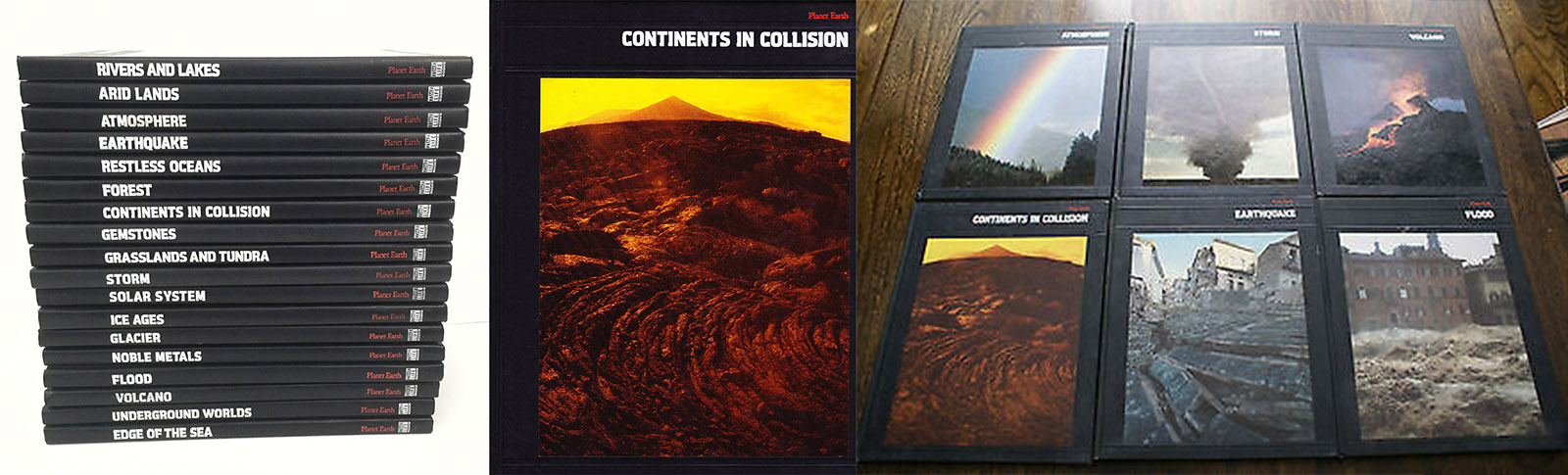
Most crucially, I shared this post to the Mystara Reborn Facebook group. No one had the book at hand, but Richard Balsley suggested that it was Continents in Collision, a book in another Time Life series, Planet Earth, that had the maps in it. Again I asked my father, but it was not to be found.
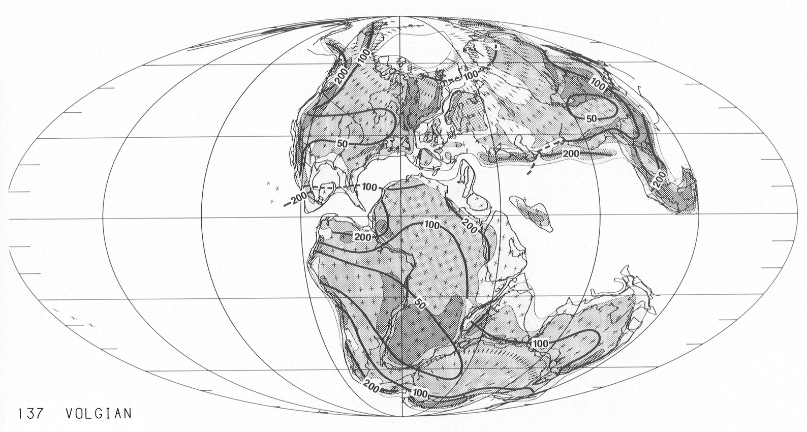
Then a few days later Andrew Durston not only said he had the book — he even provided a scan of the page in question.
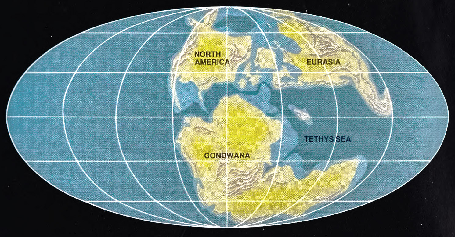
And there it was — the map that in all likelihood inspired Mystara!
It’s captioned as 135 million years ago, although it bears much more resemblance to the present paleogeographic maps showing Earth 150 million years ago.
Look closely and you will see that all of the major land masses are there, and they are largely the same as Mystara’s world map, which was provided in the Master Rules Set. There are a number of minor differences, but the resemblance is undeniable — even the mountains are in roughly the same places.
Continents in Collision was printed in 1983. (Google Books and Amazon.com both list 1st January 1983 as the publication date, although this may simply mean that the date is unknown.) The Master Set was released in 1985, but the Companion Rules Set as well as CM1 Test of the Warlords both included continental maps of Brun in 1984. Meanwhile 1983 saw the release of X4 Master of the Desert Nomads and X5 Temple of Death, whose maps may be considered to be derived from the world map. X6 Quagmire! followed in 1984 with the Serpent Peninsula.
So the timing is tight, but not impossible.
Lance Duncan brought up some quotes from Frank Mentzer about the origins of the map:
Some of the Suits wanted to create their own in-house campaign world for D&D (i.e. no royalties for a change) and thus Mystara was born. It started with a worldmap of Pangaea from Francois Froideval, twiddled by yours truly, and introduced in brief in the DM’s Companion and extended to the entire world in the Master DM’s Book.
Frank Mentzer, 4th August 2005 at in a thread at Dragonsfoot
You can see more relevant quotes on Lance’s page. Frank Mentzer mentioned that he and François Froideval “played with plate tectonics as early as ’82” (The Piazza, 23rd October 2013).
Finally, John Tudek found the book on his own bookshelf, and provided me with a high resolution scan, which I tweaked to show the mountains more clearly.
John also checked the artist credit, and found that it was credited to Dr. Christopher Scotese — the same man who is still making these paleogeographic maps today. (He’s pretty famous for them, in fact.)
So what happens when you overlay the Master Set world map on this map? Let’s take a look!
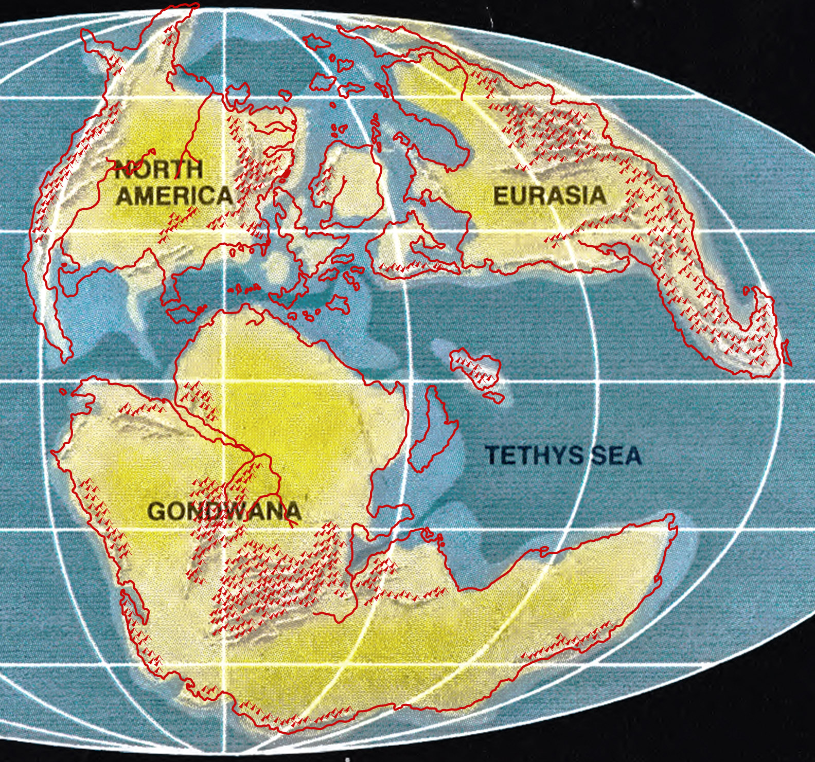
To say the resemblance is striking would I feel be an understatement. It’s practically spot on; although the exact placing of the continents is not quite identical, the mountains are so close that I think we can say with confidence that it was this map — or at worst perhaps a very close relation — that François Froideval brought to Frank Mentzer back in 1982, and which they used as inspiration to create Mystara’s world map.
Further, we the loose fit of Brun in the above map compared to the other continents may suggest that it was perhaps done separately — as indeed you might expect, since it was published first, as noted above.
Taking a closer look, we can see that the coastlines of Davania are almost a perfect fit, with the two major exceptions: the Addakian Sound, and the Vulture Peninsula. Cestia and Everfeed are also missing, although Oceania is present. Davania’s mountains are very close, with the following differences: the Addakian Mountains have been expanded, while those north of the Izonda desert have been much reduced. Also the northwestern coast is free of mountains on Mystara.
Skothar’s coasts are very similar, although the extreme north is hard to make out. The small islands are almost all missing, however — including Zyxl in the extreme east.
The Alphatian Sea area has close versions of all the major subcontinental islands, including Alphatia, the Isle of Dawn, and Bellissaria. It also has a much larger-looking Ochalea, slightly off from its Mystara position.
Brun fares the worst, with quite a poor match. But does the Companion Set Brun map fit any better?
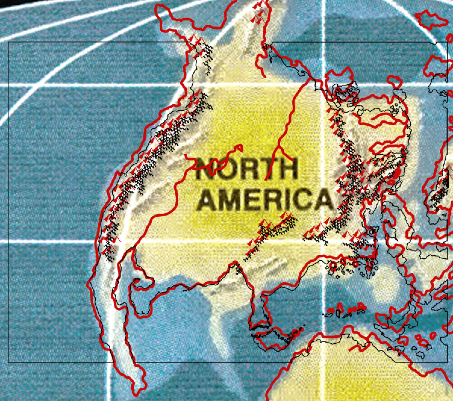
Well, no. Not really. It’s a bit of a mess, although the pattern of the mountains at least does line up nicely.
So what now?
You may be wondering: okay, so now what? That is a very good question.
In my opinion, we can use two things from these maps directly in today’s Mystara: the mountains, specifically the shape of the ranges; and the sea depths, meaning the extent of the shallower coastal shelves and the deeper oceans. Both of these are welcome additions to Mystara’s body of maps. The shape of the mountains should help especially with my current work filling in the hex maps for all three continents, but also with future projects where such knowledge will be very useful.
Of course, it’s all just guidelines, and I don’t expect any of this “new” information to override things that are already set.
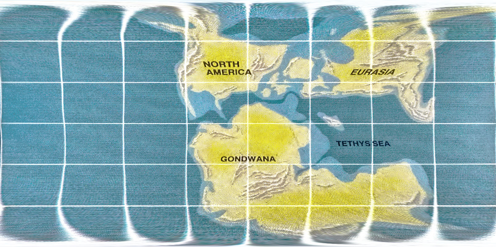
The other point is a little more complex, and it’s to do with projections. We now know that the map that inspired Mystara was in the Mollweide projection. Which begs the question, what does this mean for Mystara’s world map? Should we also interpret it as being a Mollweide map?
As it happens, Lance Duncan has already done just that. You can see his treatment of this (centred on Karameikos, but also including the world map) over at his web page, where he has a great interactive Mystara Web Map. Out of interest, here’s what happens when you reproject the Mollweide projection proto-Mystara map into an Equirectangular projection:
My own answer to this question is a definite no. Why? Because such a top-down approach at this point in Mystara’s lifespan, when every map so far has ignored the issue of projection altogether, and our primary concern is hex maps with a marked scale… would inevitably mean rescaling all of those maps at best, or at worst having to redraw them all — effectively throwing out everything we have now and starting anew.
My solution, as outlined two years ago in my Lining Up Mystara project, is to treat all of the maps as if they are Equirectangular projections. The reasons for this are twofold: it preserves the “top is up” aspect throughout the maps; and it preserves the north-south scaling of the maps, so 8 miles per hex will always mean 8 miles per hex — as long as you are measuring straight up and down. This last part is a bit of a cop out, but it’s also the best of a raft of bad choices, because no choice of projection can make the hex maps read 8 miles per hex in any direction; in fact, that is simply not possible in a 2D representation of a 3D ellipsoid.
It’s not perfect, but I believe we have a consensus in the community to go this route, since it makes the least trouble.
In short, Mystara is a uniquely complex world, with its polar openings and Hollow World also to take into account, and quite large sections of the world already mapped in beautiful large scale (8 mile) hex maps. For many of us, the world needs to be reconciled in three dimensions; for others, it’s not really a priority. With the Atlas of Mystara, I propose to walk a middle ground that satisfies both these groups.
I leave it to others to recreate the world anew from this inspiring map. And — I can’t stress this enough — I would love to see such a project happen. I’ll be the first in line to cheer it on, and indeed help out where I can.
Phew! What a day — what a week! — this has been. Thirty years on, and I’m still getting thrilled by Mystara.
Here’s to another thirty years!
Speaking of which…
With apologies for the self-promotion… It’s not Mystara, but if you’d like to see more maps from me and support my cartography, please check out my Patreon. It’s thanks to my patrons and other supporters that I am able to continue with projects like this and develop new skills and techniques to apply to all of my maps.
Thanks for listening!


8 February 2018 @ 5:22 am
My question is whether (or how much of) this map was fully envisioned in 1981, when Isle of Dread introduced the Known World.
8 February 2018 @ 9:14 am
I’m reasonably sure the answer is none at all.
Frank Mentzer provided the world map a few years later, and it seems very likely that he shoehorned the Known World map into it at that point.
Aside from the timing, the latitudes also point to this being the case, as Mentzer’s map places the southern coast of the Known World at about 25°N, which seems far too far south.
My 2016 model pushed the countries to roughly match the latitudes given on TM1, so the southern coasts of the Known World are just above 30; that’s still further south than I’d like, but there’s not much else we can do to fix this.
2 April 2018 @ 9:22 pm
Why use 8 miles? Go back and look at the history of units of measure. There are other units of measure that will give you more exact detail. I’m not talking about metric. If you use 20 miles per hex, it gives you one scale. English units of measure begin with a barley corn and work up from there. A battle map should use fathoms, which is the measure from the tip of the fingers on one hand to the tip of the fingers on the other hand if they are held straight out to the side. That is the span of a man’s reach. It scales up to a rod, a chain, a furlong and finally a mile. A league is 3 miles.
I simply think if you’re going to simulate the medieval world, perhaps you should use their units of measure to represent things.
14 February 2018 @ 2:58 am
Excellent!
14 February 2018 @ 1:17 pm
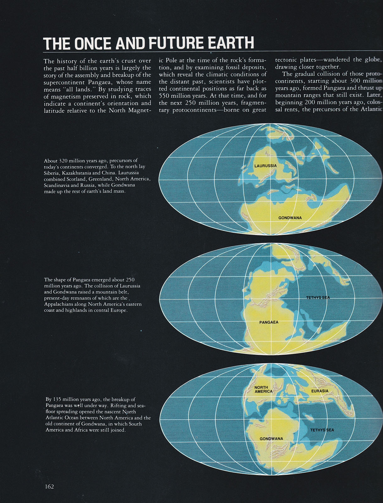
The other two(?)* maps from “The Once and Future Earth” could be used for the maps of the parallel Mystaras mentioned in CM6: Where Chaos Reigns.
*(Is there another page of paleo maps in that book?)
Maybe the next older map (250mya) for the world map of Aelos.
7 March 2018 @ 6:14 pm
Just my 2¢€: have you ever looked at http://deeptimemaps.com ?
7 March 2018 @ 6:17 pm
Yes! Ronald Blakey is the other famous cartographer behind paleogeographic maps. I’ve been a fan of both his and Christopher Scotese’s works for many years now.
Master Set Outer World | Atlas of Mystara
10 June 2018 @ 5:02 pm
[…] was not posted online until it was unearthed once again in February 2018. For the full story, see this article on […]
Let’s Map Mystara 1984 – Thorfinn Tait Cartography
12 September 2018 @ 3:55 pm
[…] was not posted online until it was unearthed once again in February 2018. For the full story, see this article on […]
CM1 Brun | Atlas of Mystara
6 April 2019 @ 11:27 am
[…] was not posted online until it was unearthed once again in February 2018. For the full story, see this article on […]
Let’s Map Mystara 1985 – Thorfinn Tait Cartography
2 May 2019 @ 9:00 pm
[…] not posted online until it was unearthed once again in February 2018. For the full story, see this article on […]
Lining Up Mystara Revisited V – Thorfinn Tait Cartography
13 June 2019 @ 8:31 pm
[…] my experience with Jurassic Earth, it occurred to me that my hack-up of the Hollow World back in 2016 actually had an unfortunate […]
Lining Up Mystara Revisited IV – Thorfinn Tait Cartography
13 June 2019 @ 8:48 pm
[…] on Facebook, I decided to keep my 2016 model’s hex map-based coastlines. The match with the Jurassic Earth map is really not tight enough to warrant […]
Skothar, 72 miles per hex | Atlas of Mystara
21 June 2019 @ 7:58 pm
[…] of the Earth 135 million years ago (the “Jurassic Earth” map), page […]
10 March 2021 @ 12:01 am
For a modern, 3D version of 150 million year old Earth, see https://dinosaurpictures.org/ancient-earth#150
Outer World (1985) | Atlas of Mystara
23 January 2022 @ 12:00 am
[…] “Jurassic Earth” map (article at Thorfinn Tait Cartography) […]
Proto Mystara | Atlas of Mystara
7 March 2022 @ 8:48 pm
[…] is a whole story behind the discovery and rediscovery of this map, for which see my 2018 article, Jurassic Earth as Mystara. Suffice it to say, it was common knowledge back in the 80s that Mystara’s map was based on a […]
25 May 2023 @ 2:06 am
If I am correct, Alphatia lines up with where Scandinavia would be. So, Sundsvall in Alphatia is close to real world Sundsvall in Sweden.