
2018 Mystara Project Updates
It’s high time for an update on the state of my Mystara projects, don’t you think?
Lining Up Mystara
I have begun work on codifying my Lining Up Mystara project. After finishing it almost two years ago, I haven’t had time to work on it much more, which I regret. So I have laid aside a little time to work on it this month, and hopefully at least get some of the results published.
The aim of this project was always to create a finished set of world maps for Mystara, resolving all of the major issues Mystara’s cartographers have been dealing with for the past thirty years or so. I sought community consensus on most issues, and the result may not please everyone — especially in the small details. Obviously, there’s no reason why everyone has to use my maps, and I would never presume to even ask you to do so.
That said, however, working within a cohesive framework of maps would come with terrific benefits: increased compatibility between each other’s maps, easy development of old and new areas, and of course being part of a full set of world maps — with georeferencing, and which can be placed on the globe.
But none of this is possible until I publish the base maps from my project. This is what I’d like to do this month.
So where are we at?
I have now completed georeferencing on both the Outer and the Hollow World. What this means is that I have a master map for each world, with latitude and longitude coordinates locked in. Using Photoshop and a plugin called Geographic Imager (or indeed Illustrator with MAPublisher), I can begin to georeference other maps, sharing assets (coastlines, rivers, etc.) between then and generally making expanding things a bit easier.
It also means that every settlement now has coordinates. And I can do things like calculate areas or measure distances with ease. Of course I can also add the maps to the 3D globe model with great accuracy, and indeed create alternate projections to show the world with different parameters from what we’re used to.
But I know that what really interests most of us is the hex maps. So my next step is to create master hex maps, marking very general terrain along with highly precise coastlines and major rivers. I’ve split the Outer World into three maps, one for each continent.
Remaining Issues
I’m sure you’ll be unsurprised to hear that there are still some outstanding problems to overcome in creating this set of maps.
Although I tackled almost all of the major issues in my project two years ago, I mainly concentrated on the big things: reconciling the hex maps of various scales, working in the shapes from the world maps without breaking the hex maps, and fixing down the precise relative locations of all the major landmasses.
But there are still some rough edges to deal with, and as always I’d like to ask for your feedback before moving forward with these.
The Yalu Bay Problem
One of these issues that I have yet to tackle is the precise shape of Yalu Bay. I’ve been talking with Carillion about his wonderful Orc’s Head Peninsula/Trident Bay/Great Northway Lands map, which stunningly recreates one of the only official maps I have yet to reproduce: Dungeon 6’s Great Northway Lands. He did a really great job of this.
Unfortunately, the Dungeon 6 map is also a confluence of discrepancies between all of our sources. In particular, we have a real headache in the coast of Yalu Bay and the precise location of the Mud Water Cove — the estuary of the Great Northway River. No, in fact it’s the Yalu River (more of this in a moment).
To sum up the situation, we have the following sources, grouped together like this:
- Companion/Master Set Brun and world maps
- Hollow World Set Outer World map
- X9/Dungeon 6 24 mile per hex maps
- Princess Ark/Red Steel/Savage Baronies 8 mile per hex and non-hex maps
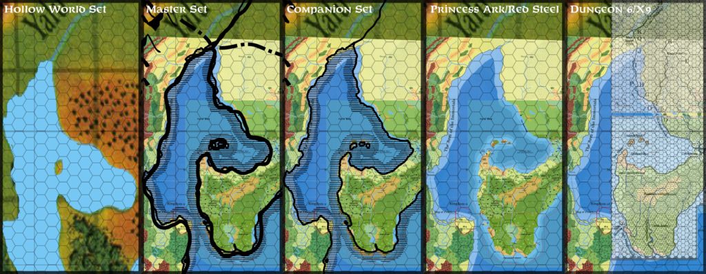
Option 1: The continental and world maps are problematic as sources in that they require alignment with other landmarks in order to resolve their exact locations, and I’ve established previously in my Lining Up project that there is no single fit — I had to cut Brun up into a number of sections to make it fit properly. So in theory, the continental maps could be placed in relation to either of the other groups. In practice, they don’t fit very well anyway, and are more useful as general guidelines; typically, lining them up with one thing will make everything else go out of sync. Nevertheless, we already have these placed to the Orc’s Head Peninsula in order to define the relative position of it to the Arm of the Immortals, so it is an option.
I’ll dismiss the Hollow World Set map out of hand; I had to warp it severely to get it to fit at all, and in general the fit is a nice guide for terrain, but not worth looking at beyond that. This was previously noted in the Lining Up series.
This leaves us with two competing groups, representing the first era of mapping and the later stage. Both groups are internally cohesive, but they’re largely incompatible with each other.
Option 2: X9 fits nicely with Dungeon 6 (unsurprisingly since Dungeon 6 incorporates most or all of X9).
Option 3: Similarly, the 8 mile per hex Princess Ark maps fit very nicely with Red Steel, which in turn fits rather well with Savage Baronies (after rotating — for unknown reasons that map did not have north pointing directly up).
Now, the general policy of the Atlas of Mystara is to give priority to larger scale maps, and also to newer maps. So my instinct would be to go with the option 3, which after all includes both of these things.
But at the same time, Dungeon 6’s map includes information not available in any other source, which of course also deserves to be added to our mix. The Yalu River valley is a significant portion of this.
It turns out that the incompatibility between X9 and the Princess Ark 8 mile per hex maps is not total, nor indeed completely uniform. The Orc’s Head Peninsula is offset one 24 mile hex to the southeast compared to X9, while the Bayou seems to be offset by half a 24 mile hex in the same direction. The Tall Grass Coast northwest of the Bayou does not align well between these two groups, and the Savage Baronies map’s position of the Yalu River’s mouth is about a hex and a half south-southeast of Dungeon 6’s.
What to do?
Here’s my proposed solution: as none of these seems to stand out as the best solution on its own, perhaps a compromise would be best.
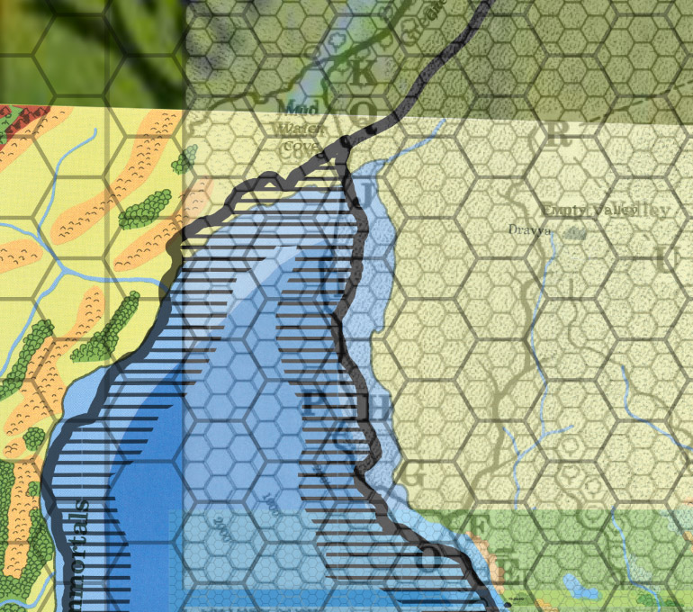
Since I’ve used CM1’s outline for the coasts of the Arm of the Immortals, it seems reasonable to use it here, too. There’s a further issue: the inland Yalu Sea’s location also needs to be fixed by this map’s placement. While Dungeon 6 is a nice map, it perhaps overlooks that the river here is not in fact the Great Northway River, but rather the Yalu River, which flows down all the way from the Yalu Sea to the northeast.
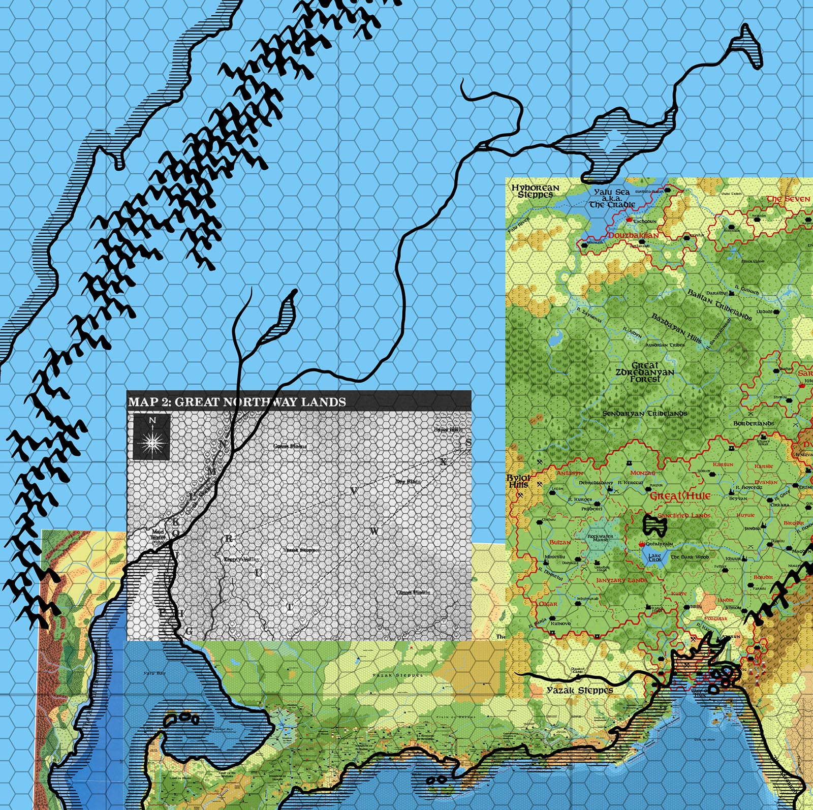
I’ve pasted in Christian Constantin’s Hule & the Midlands map for reference here. It would appear that the Yalu Sea should be a little further north than he has placed it, going by CM1. Taking into account the weirdness with the Savage Coast (which for some reason on the hex maps seems further north than the continental map shows), it’s perhaps two big hexes (they’re 72 mile hexes) south of where it should be. Going solely by this placement, it’s there hexes too far south.
In any case, note that Dungeon 6’s map taken with CM1 would place the Yalu Sea another 72 mile hex north.
I can actually see two possible compromises:
Compromise 1: Take the Great Northway Lands map as is for the lands shown on the map, except where over-ridden by an 8 mile hex map. This means all of the land from just north of the Bayou would be taken from the Dungeon 6 map rather than Red Steel or Savage Baronies. The west coast of Yalu Bay uses CM’s coast from where Dungeon 6’s map ends. The resulting Yalu Bay will extend one 72 mile hex north of CM1’s map. Finally, use Dungeon 6’s positions for the Yalu River where it is shown. At the branch just before the map ends, merge into the rivers shown on CM1. Thus the upper Yalu River and tributary (including its lake) will be exactly as shown on CM1, but the lower parts will be as shown on Dungeon 6’s map.
Compromise 2: Revise the Great Northway Lands map to use CM1’s Yalu Bay outline in its entirety. This means moving the river valley one 72 mile hex southeast. Another option would be simply to move the whole map one 72 mile hex southeast, which has the advantage of lining it up better with the Bayou’s central island. It would also move Yazak and Richland closer to where they are shown on the Savage Baronies poster map, perhaps allowing the terrain from both maps to be merged.
It all comes down to placement of Dungeon 6’s map. I’m thinking perhaps Compromise 2 is the best option here, since it preserves all the maps by altering the placement of Dungeon 6’s map — which is already out of sync with the 8 mile per hex maps, since its bottom half is based on X9, while the 8 mile maps have their own separate configuration.
Phew! If you were able to follow all that, please let me know which of these you prefer — or if you have any better ideas to resolve this.
Once this issue is settled, I have at least one more for your consideration.


8 January 2018 @ 3:59 am
One thing That maybe of help, though still confusing, is something I noticed in making my 1 mile hex maps….is that not all hexes are equal…several (canon and fanon) are not equal in diameter along all 3 axis…I resolved this by stretching the map as a whole to make it fit, and this alone did help greatly. maybe it is just enough for you to check/repair this where needed.
As to your compromises….I feel that the Dungeon 6 map, though very nice, may be the most off as seen to the other canon maps. as thus i feel more to compromise 2 moving the whole map…not only does this seem easier, it feels better as in respect to the various map sources
8 January 2018 @ 4:02 am
Thanks for commenting, Robin! That’s pretty much my feeling, too. Moving the whole map seems like the least intrusive option at this point, and it solves most of the misalignment issues.
8 January 2018 @ 7:50 am
Hello Thorf,
I think we should go with option 1.
Firstly, the positioning of the tortle mounds on the DM6 map are carefully placed so that they all line up with the Monoliths of Zul (which is a tortle ruin). These placements also form the route of the Portals to Everyland – please see the linked map below:
https://drive.google.com/file/d/1ZMbEtRYgWLFswryioaOIxM8mrlLSwsbf/view
Therefore, shifting this map will throw the line up of the portals completely out, which I’m obviously against.
Secondly, option 2 seems to be giving preference to the CM1 map over a canon hex map. We’ve always done the opposite approach before (and for good reason), so I’m not sure why it should be different this time. It would be like revising all the Savage Coast hex maps to fit CM1! Also, the Red Steel maps form part of an AD&D boxed set, and is not a Mystaran product at all. It is true that it gives some nice terrain information, but I only think we should be using it if it doesn’t directly conflict with Mystaran products. If we are to take the Red Steel maps as an authoritative source above the Mystaran canon hex maps, then the hex maps for the entire area directly east of Slagovich would also have to be completely redrawn. Obviously we aren’t going to do that, but this shows that option 2 is not in any way consistent with the approach we’ve always used previously.
Well, that’s my two pennies worth, anyway!
Matt
8 January 2018 @ 1:28 pm
Hi Matt!
Thanks for commenting here! I was eagerly awaiting your ideas. I must confess I don’t know that much about this map, nor the adventure Tortles of the Purple Sage — I only added Dungeon 6 and 7 to my collection not that long ago, and I haven’t even scanned the maps yet. So I bow to your expertise on these issues.
That said, I think you’re overlooking something very important: Red Steel’s map is actually very much in agreement with the Princess Ark series hex maps, which of course are the best source for this region. So when I refer to the Princess Ark/Red Steel maps, I’m primarily referring to the 8 mile per hex maps. Also, I absolutely agree with you that Dungeon 6’s map takes precedence over the extra details from Red Steel and Savage Baronies, which I’ve criticised in the past for being painted with too big a brush and generally lacking in fine detail. I see these as being on a similar level to the world maps, which is to say they just describe the general terrain in those areas. Other sources and further development can and should override and replace much of this terrain.
In any case, I think we’re actually on the same page here, aren’t we?
The main problem arising here is how the 8 mile hex maps relate to the 24 mile hex maps. The continental maps do need to be factored in a little, because this is the edge of the hex mapped world and we need them to expand the world further, and also because unfortunately the hex maps for the Orc’s Head Peninsula and the Arm of the Immortals got the relation between these areas wrong. (And there’s your example of a continental map overriding a hex map.) But I agree that the hex maps should take priority in general.
Getting back on topic… Your map with the triangulation lines is very helpful. Are these from Tortles of the Purple Sage? I’m familiar with the light purple lines linking Bylot with Yazak and Dravya, but not with the rest.
One question: I can’t see the Monoliths of Zul on Dungeon 6’s map. Were these only present on the Princess Ark map?
Perhaps it would help if I did a direct comparison between the 8 and 24 mile hex maps for this area. I suspect that the alignment problems between the 8 mile Savage Coast and your X9-based 24 mile Savage Coast still apply here.
8 January 2018 @ 6:23 pm
I’ve been reading Tortles of the Purple Sage, and I’m having a bit of trouble seeing how this can help us with placement. Your map seems to have a lot more detail than the rather sparse map in Dungeon 6, which only seems to include Bylot, Yazak, and Dravya with their triangulation lines.
Did you derive these from this article and map by LoZompatore? http://www.pandius.com/drvshciv.html
This is all great stuff, but there are a few problems. First and foremost, these are not official sources. I agree that a solution that allows secondary sources to work would be best, but using this info at this stage would indeed be breaking my own rules.
Moreover, the relations drawn out by LoZompatore are on a map that is directly based on CM1’s Brun continental map. I’ve already demonstrated that this map is not compatible with Dungeon 6’s map. The extent to which these maps differ is actually quite drastic, with Dungeon 6 presenting a far longer version of Yalu Bay than the continental map.
Finally, the precise locations of the settlements on the 8 mile per hex maps are not entirely consistent with your 24 mile per hex map. Look at Dunwick and the Monoliths of Zul, for example, and you’ll see that they are further away from each other than you have them on your map. The Monoliths of Zul are one hex to the east. So I think it may take some tweaking to get all this to fit anyway. (Risilvar and Gurr’ash are in the right spots.)
I think I need to put together another post exploring these issues.
8 January 2018 @ 8:37 am
Sorry, one more observation – I’ve always taken the ‘Great Northway River’ and the ‘Yalu River’ to be different names for the same river. Certainly no map shows two large rivers flowing into Mudwater Cove from that direction. Also, the Hollow World boxed set (where the name ‘Yalu River’ comes from), came out after DM6 and I suspect they didn’t realise the river already had a name and so they called it something else.
Also in DM6, the description of the Great Northway River is as follows:
This wide, powerful river empties into Mudwater Cove. It is navigable for thousands of miles inland…”
This is clearly describing the ‘Yalu River’ as that is shown in the Hollow World Boxed set to flow thousands of miles inland as well.
Regards,
Matt
8 January 2018 @ 1:29 pm
Totally agree with you here.
9 January 2018 @ 5:26 am
Hello Thorf,
Apologies for any confusion, I wasn’t trying to infer that all of those placements in my map were canon – I didn’t have a map to hand which only showed those. Some are fanon placements, and I see you have already found the relevant article from LoZompatore which details the background.
Just to clarify with regards to the positioning of the ruins, Bylot, Yazak and Dravya, together with three different tortle mounds are in the same triangular pattern and are all canon, as they are all shown in the map in DM6.
The Monoliths of Zul were created by Bruce Heard sometime later, but as they also form a triangular pattern with some of the ruins which are canon, and are also confirmed to be Dravya/Tortle ruins, I’ve always believed this to be intentional. I suppose it is possible that it’s all a bizarre coincidence – who can say! I doubt Bruce would be able to remember now anyway so perhaps we will never know!
There is also confirmation of four lost Dravyan cities in canon, but the actual placement was never given, so you can certainly place those anywhere in the area. If you notice, my placements are slightly different than LoZompatore’s due to the variances in the maps (which you’ve noted above). You could certainly place those ruins after you have completed your map – that’s what I did!
My main reason for mentioning this previously is that some care will need to be taken if you go for option 2 so that the canon triangular placements don’t get lost. At this point, I can’t visualise quite what option 2 will look like, so I felt flagging all this at this point might be a good idea.
I hope that clarifies matters!
Regards,
Matt
10 January 2018 @ 1:46 am
I’m Not sure if you have conflicts with the river itself, but if you do just remember that rivers are not static. Barring man-made manipulation, unless they are – or previously were, strong enough to carve a deep channel, and swift enough prevent deposition, river systems are very dynamic. Even the mighty Mississippi is constantly evolving and shifting. Canyons are about the only time that rivers are static for mapping (ie the Danube in the Iron Gates or the Colorado in the Grand Canyon). So if your sources conflict with respect to the river, just consider them to be different years.
10 January 2018 @ 9:06 am
Hi Thorf!
I was sure the time when you took back the world map of Mystara in your hands would arrive sooner or later! I’m looking forward to the complete map I’ve been waiting for since “Lining Up Mystara XIX” two years ago… 😉
About the Yalu Bay issue, I’d go with the option to move Dungeon #6 map one 72-miles hex to the south-east to fit with the rest of the canon maps and to have the Great Northway River’s mouth from the former match with the Yalu River mouth from the latter. “Tortles of the Purple Sage” is a scarcely known adventure after all, and even if it features a 24-miles hex map, it belongs to the very first generation of Mystara products. Then I would find more reasonable to give precedence to VotPA’s maps, and eventually – since they derive from them, as Thorf explained – to Red Steel maps.
I’m aware of the problems pointed out by Matt about the paths linking some Dravish cities at certain angles, but – as Thorf said – Dungeon #6-7 has very sparse informations about them, and most of what we assume about the Dravish civilization in the Great Northway/Savage Coast area comes indeed from LoZompatore’s excellent article. Re-reading it after many years, I realize that some assumptions LoZompatore made have not to be necessarily true. Some examples:
a. Risilvar as a Dravish city. This assumption is based on the fact that the sacrol (an undead monster) found there in X9 speaks Dravish language, and on the presence in the city of a teleporting device (a “Wheel of Infinite Travel”) which calls to mind the teleporting magic of the Dravish civilization to the north. Now, it may well be that Risilvar was a Dravish city, but not necessarily part of the Bylot-Yazak-Dravya teleportation network – which is marked by actual paths on land (like the Nazca lines) that are not found in Risilvar nor in any of the other supposed Dravish settlemente besides the canonic ones in Dungeon #6-7. Besides, the Wheel is actually a very different device from the teleportation gates found in Dravya and the other cities.
b. Six “Nazca” paths for each city. Dungeon #6-7 only has one path stretching from one Dravish city to another, as indicated in Map 2 of the first part of the adventure (the triangle between Yazak, Dravya and Bylot). Each city has however six teleportation gates. It’s not necessary to assume there’s a line starting from each gate, since the lines are not magical, and have a religious meaning (as clearly explained on page 22 of Dungeon #7 – in fact only “some lines correspond with teleport directions of the magical gate stones”). Since it’s the lines which have to be straight and not the teleportation paths, and since there are only three paths (those shown in the adventure), I would not bother to leave Dungeon #6-7 map untouched if this prevented to solve major mapping inconsistencies in the region.
Hope this helps!
Simone
11 January 2018 @ 5:28 am
Hello Simone,
Good to see you join the discussion!
OK, I’ve had a look at this again, and now realise that Option 2 actually contains two options in itself! I’m happy to go with one of these – namely moving the river tributary by itself one 72 mile hex to the Southeast, whilst leaving the rest of the DM6 map untouched. That leaves most of the triangular patterns we’re discussing as they are, and also deals with a secondary issue which has not yet really been discussed – namely, the position of the Dry Flats which is only placed by the DM6 map. By leaving the rest of the map as it is, the placement of the Dry Flats also remains unchanged, and therefore causes no further issues.
Also, I suspect the cartographer for DM6 was trying to replicate the river tributary shown on CM1, but mis-aligned it slightly as it was being done by hand (I can see no reason why he would intentionally change it). Therefore, it can be argued that all we are doing here is amending a previous error. We can then use Thorf’s 24 mile hex map of the ‘Arm of the Immortals’ (which ties up with the Red Steel map) and so we will have this region pretty much covered off.
I also agree with Thorf’s suggestion of adapting some of the additional terrain details from Red Steel to the DM6 map (in fact, I’ve already done this on my map). The vanilla DM6 map is a little too sparse for my liking, and in addition, doesn’t even show all of the terrain detailed in the accompanying article! This should be added as well (again, I’ve done this on my map, but some my placements are a little arbitrary, and so are subject to change).
Simone – just to let you know that I sent you a PM on the Piazza about a week ago about an unrelated topic, so please check your mail!
Regards,
Matt
13 January 2018 @ 7:48 pm
@Matt: Mail checked and answered, thank you! 😉