
Narwan Topographic Map (Patreon)
Today I am proud to present to you the first map from my Patreon campaign: The Emirates of Narwan Topographic Map.
Before I continue, I’d like to acknowledge the generous support of my patrons for November 2016:
Jesper Andersen, Azure Admiral, Trenton Bergeron, David Chart, Francesco Defferrari, Bruce Heard, Grégory Le Louette, Wendy Lord, Harri Mäki, Gordon McCormick, Sverre Midthjell, Thomas Pizard, Friedrich Röhrer-Ertl, Kurt Stoffer, and Sandra Tait.
It’s thanks to these fifteen wonderful people that I can publish this map here.
Special thanks also go to Bruce Heard, who pulled out all the stops to further develop Narwan and make this a map to remember.
I’d also like to thank all those who have helped spread the word about my Patreon, as well as those of you who have pledged since. Every backer is one step further along the road for me, and I’m very excited to see where that road goes.
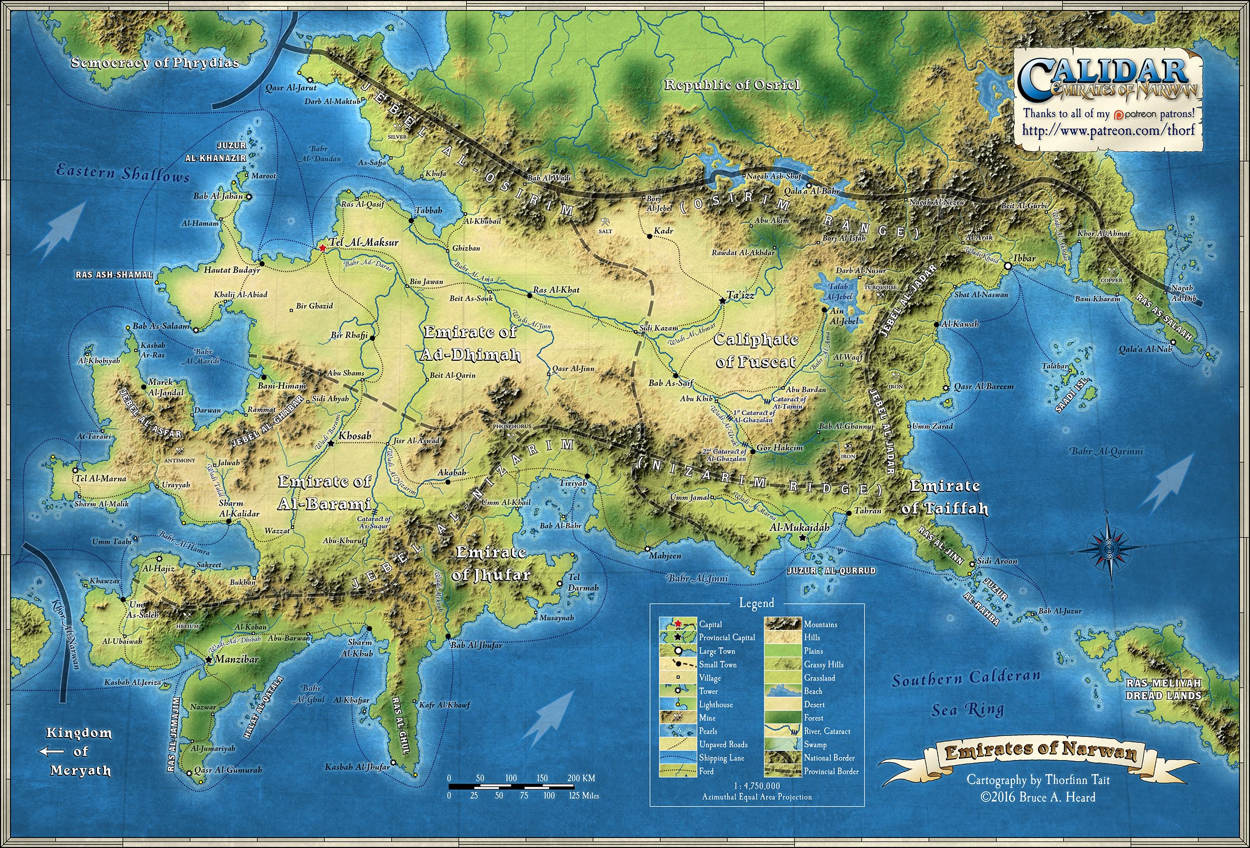
But first, let me explain this first map. It’s a two page spread of the Emirates of Narwan, designed to be ready to print in a book, which means the map is about 16.5 x 11 inches, plus bleed (an extra 1/8 inch). The middle section of the map has been carefully placed so that details of the map don’t fall into the binding of the book.
For now, of course, this is a file in your computer. The version I am publishing here is 150 DPI, or half the full resolution. I am releasing it under a Creative Commons Attribution-NonCommercial-NoDerivatives 4.0 International License, with the permission of the copyright holder, Bruce Heard. This means that you are welcome to share the map online, introduce it on your blog, and so on, as long as you attribute the copyright, and I hope the cartographer too! At the same time, it is an official Calidar map, so please don’t use it to make other maps, and of course you can’t sell it or use it for any commercial purposes.
Now, with that out of the way… As well as endorsing and indeed backing my Patreon campaign, Bruce has contributed new details for this map, developing Narwan’s geography into a far more fleshed-out form. Compared with the Great Caldera map in CAL1, you can now see villages, mines, and lighthouses; trails have been revised and expanded to crisscross the realm, and shipping lanes are in place; the major rivers have all been named and labelled; and there’s even a new symbol for pearls in the southeastern corner.
It’s a more complete picture of Narwan than we’ve ever seen before.
In addition to this, I have continued to refine my topographic style, as previously seen in the Great Caldera and Meryath maps in CAL1, as well as Osriel, Ellyrion and indeed Narwan maps in CC1. I hope you’ll agree it’s getting better and better — again, this is largely thanks to my Patreon community, who have been great at providing feedback over the last week.
So what do you think?
If you have any comments or suggestions, please fire away.
This is only the first in what is to be a regular feature. If you’d like to support these Calidar maps, please head over to my Patreon and check it out. If you’d like higher resolution versions, you should know that becoming a patron will unlock access to these, too.
Here’s to many more maps!